
Union Moraine facts for kids
The Union Moraine is a long ridge of rocks, sand, and clay left behind by a giant glacier. This glacier, called the Laurentian Glacier, covered much of North America a long time ago during the Ice Age. The Union Moraine is like a big, curved line that shows where the edge of the glacier was at one point. It stretches across parts of Ohio and Indiana.
This moraine starts in Ohio, near Bellefontaine, which is close to Campbell Hill, the highest point in Ohio. From there, it goes southwest towards Greenville. The moraine then reaches Union City, Ohio, which is how it got its name. After Union City, it travels west to Muncie, Indiana. Finally, it turns northwest and ends near Bunker Hill, Indiana, close to the Wabash River. The Union Moraine is the outer edge of several moraines made by a part of the glacier called the Huron-Erie lobe. It shows a time when the glacier pushed forward one last time.
Contents
What is a Moraine?
A moraine is like a natural wall or hill made of dirt, rocks, and other debris. Glaciers are huge sheets of ice that move very slowly across the land. As they move, they act like giant bulldozers, scraping up everything in their path. This material gets carried along by the ice. When the glacier melts or stops moving, it drops all this material, forming a ridge or mound. This is what we call a moraine.
How the Union Moraine Formed
The Union Moraine was created by the Wisconsin Glaciation, which was the most recent major ice age. A part of this huge glacier, known as the Huron-Erie lobe, pushed forward and then paused or melted back. As it did, it left behind the Union Moraine.
In some areas, like east-central Indiana, the moraine has bumpy land with small hills and channels. These features were formed when blocks of ice melted and left behind the dirt and rocks that were on top of them. Two large systems of ridges, called eskers, are found near Anderson and Muncie. These eskers are like long, winding hills made of sand and gravel that formed inside tunnels within the melting glacier.
Exploring the Moraine's Landscape
The ground in the Union Moraine area is mostly made of clay. This is different from the sand and silt found underneath it. In places like Wabash County, Indiana, this clay layer is thin, often less than 3 feet deep.
The surface of the land around the moraine looks different depending on the type of soil. Some areas have low, bumpy hills that drain water inside them. Other areas have similar bumps that are part of a natural drainage system. These differences are because of how easily water can pass through the different types of soil.
There are also long, narrow, shallow channels that cross the flat land between the Union City and Mississinawa Moraines. These channels were likely formed by water flowing under or within the melting glacier. You can also find large, wet, boggy areas.
The Muncie esker system is a notable feature, along with two ice-walled troughs in southern Grant County. These are all signs of how the glacier melted and shaped the land.
Glacier's Journey and Impact
As the glacier moved forward to create the Union City Moraine, it traveled over land that was mostly clear of ice. However, in some areas, it might have moved over thin layers of old, stagnant ice that had a lot of debris in it.
Even though the glacier moved over these areas, it didn't destroy the gravel-filled channels that were already there. Instead, it spread a thin layer of clay-rich soil over them and over the old, stagnant ice. This suggests that the glacier lobe was thin and moved easily, carrying only a small amount of silt and clay. It was able to spread across the older, stagnant ice without making it active again. This explains why the Union City Moraine looks different in some areas, especially in Delaware County, where it seems to blend with the older, dead ice landscape.
Images for kids
-
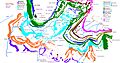
Map showing moraines south of Lake Michigan and southwest of Lake Erie. The colors show moraines from the same time period of the Wisconsin Ice Age.

