Weißwurstäquator facts for kids
Have you ever heard of an imaginary line that divides Germany based on food? It's called the "Weißwurstäquator" (pronounced: Vice-wurst-ek-vah-tor). This funny name means "white sausage equator." It's a playful way to talk about the cultural differences between Southern Germany and the northern parts. People often use it to show the difference between Bavaria and Central Germany.
What is the Weißwurstäquator?
The "Weißwurstäquator" isn't a real line you can see on a map. It's more of a fun idea. It describes a cultural border. This border separates the southern parts of Germany, especially Bavaria, from the rest of the country. It highlights how traditions, food, and even ways of speaking can be different.
Why is it called the "White Sausage Equator"?
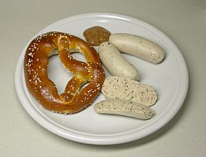
The name comes from a famous Bavarian food: the Weißwurst. This is a special white sausage. It's a very popular dish in Bavaria. People in other parts of Germany might not eat it as often. So, the "white sausage" became a symbol for the unique culture of Southern Germany.
Where is this Imaginary Line?
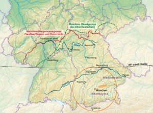
There isn't one exact place for the Weißwurstäquator. It's a bit like a fuzzy line!
- One popular idea is that it follows the Speyer line. This is a real language border. It separates different German dialects. It roughly follows the Main River.
- Another idea places the line further south. It might run along the Danube River.
- Sometimes, people say it's around the 49th parallel north. This is a line of latitude that crosses Germany.
No matter where you imagine it, the Weißwurstäquator is a fun way to think about Germany's rich and varied culture. It reminds us that even within one country, there can be many different traditions and flavors!
 | Selma Burke |
 | Pauline Powell Burns |
 | Frederick J. Brown |
 | Robert Blackburn |


