Whitesville, Virginia facts for kids
Quick facts for kids
Whitesville, Virginia
|
|
|---|---|

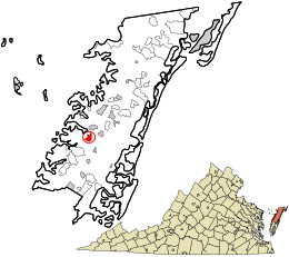
Location in Accomack County and the state of Virginia.
|
|
| Country | United States |
| State | Virginia |
| County | Accomack |
| Elevation | 30 ft (9 m) |
| Population
(2020)
|
|
| • Total | 241 |
| Time zone | UTC−5 (Eastern (EST)) |
| • Summer (DST) | UTC−4 (EDT) |
| FIPS code | 51-48776 |
| GNIS feature ID | 2584936 |
Whitesville is a small community located in Accomack County, Virginia, United States. It is known as a census-designated place (CDP). This means it is a special area the government defines for gathering information about its population. Whitesville was first recognized as a CDP in 2010. In 2020, about 241 people lived there.
Contents
Where is Whitesville Located?
Whitesville is found in Accomack County, Virginia. It sits at an elevation of 30 feet above sea level. This means it is not very high up from the ocean.
How Many People Live in Whitesville?
The number of people living in Whitesville changes over time. The U.S. Census counts the population every ten years.
| Historical population | |||
|---|---|---|---|
| Census | Pop. | %± | |
| 2010 | 219 | — | |
| 2020 | 215 | −1.8% | |
| U.S. Decennial Census 2010 2020 |
|||
Who Lives in Whitesville?
The 2020 census showed that Whitesville is home to a mix of different people. Most residents identify as Black or African American. They make up about 52.56% of the population.
The next largest group is Hispanic or Latino people. They can be of any race and make up about 24.19% of the community. White people make up about 18.14% of the population.
Smaller groups include Asian people and those of mixed race. There are also a few people from other racial backgrounds. This mix of cultures makes Whitesville a diverse place.
See also
 In Spanish: Whitesville (Virginia) para niños
 | May Edward Chinn |
 | Rebecca Cole |
 | Alexa Canady |
 | Dorothy Lavinia Brown |


