Wicklow County, Western Australia facts for kids
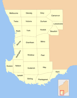
Wicklow County was one of the 26 original counties of Western Australia. These counties were special areas created in 1829 to help manage land in the new Swan River Colony. They were like early land divisions used for official records.
Wicklow County was named after William Howard, 4th Earl of Wicklow. He was an important person in Ireland at the time, known as an Irish representative peer. This meant he was a member of the Irish Parliament who represented Ireland in the British House of Lords.
Contents
What Are Counties in Western Australia?
When the Swan River Colony (which later became Western Australia) was first settled by Europeans, the government needed a way to organize the land. They decided to divide the colony into 26 large areas called counties.
- These counties were used for official purposes, like keeping track of who owned what land.
- They helped the government plan how the colony would grow and develop.
- Even though they aren't used for local government today, they are still important for understanding old land records.
Why Were They Created?
The main reason for creating these counties was to help with land administration. This means managing how land was given out, bought, and sold.
- Each county had clear boundaries, making it easier to define properties.
- This system helped create a stable way for settlers to own land legally.
Who Was William Howard, 4th Earl of Wicklow?
Wicklow County was named to honor William Howard, the 4th Earl of Wicklow. He was a significant figure in Irish politics during the late 1700s and early 1800s.
- He was born in 1761 and inherited his title, Earl of Wicklow, in 1818.
- As an Irish representative peer, he played a role in the political discussions of his time.
- Naming places after important people was a common practice when new colonies were being established.
Wicklow County's Location Today
Wicklow County covered an area that is now part of the Williams Land District. This district is still used today for land titles and property records.
- The Williams Land District is located in the Wheatbelt region of Western Australia.
- It's an important agricultural area, known for growing crops like wheat and barley.
- Understanding these old divisions helps us trace the history of land ownership in the region.
Land Titles and Districts
A "land title" is a legal document that proves who owns a piece of land. Land districts, like the Williams Land District, are geographical areas used to organize these titles.
- Even though the old counties are not used for everyday administration, their boundaries often match up with modern land districts.
- This connection helps historians and land surveyors understand how land was originally divided and settled.
 | Delilah Pierce |
 | Gordon Parks |
 | Augusta Savage |
 | Charles Ethan Porter |


