
Himalayas facts for kids
Quick facts for kids Himalayas |
|
|---|---|

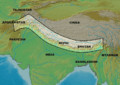
The arc of the Himalayas (also Hindu Kush and Karakorams) showing the eight-thousanders (in red); Indo-Gangetic Plain; Tibetan plateau; rivers Indus, Ganges, and Yarlung Tsangpo-Brahmaputra; and the two anchors of the range (in yellow)
|
|
| Highest point | |
| Peak | Mount Everest (China and Nepal) |
| Elevation | 8,848.86 m (29,031.7 ft) |
| Dimensions | |
| Length | 2,400 km (1,500 mi) |
| Geography | |

Mount Everest and surrounding peaks as seen from the north-northwest over the Tibetan Plateau. Four eight-thousanders can be seen, Makalu (8,462 m), Everest (8,848 m), Cho Oyu (8,201 m), and Lhotse (8,516 m).
|
|
| Countries | Bhutan, China, India, Nepal and Pakistan. Sovereignty in the Kashmir region is disputed by China, India, and Pakistan. |
| Geology | |
| Orogeny | Alpine orogeny |
| Age of rock | Cretaceous-to-Cenozoic |
| Type of rock | Metamorphic, sedimentary |


The Himalayas are a mountain range in South Asia.
The west end is in Pakistan. They run through Jammu and Kashmir, Himachal Pradesh,Uttaranchal, Sikkim and Arunachal Pradesh states in India, Nepal, and Bhutan. The east end is in the south of Tibet. They are divided into 3 parts Himadri, Himachal and Shiwaliks.
The 15 highest mountains in the world are in the Himalayas. The main ones are Mount Everest, K2, Annapurna, and Nanga Parbat. Mount Everest is the highest mountain on Earth, at 8,849 meters. Of the fifteen highest mountain peaks in the World, nine are in the Nepali Himalayas.
The word "Himalaya" means House of Snow in Sanskrit, an old Indian language. The Himalayas are so high that they kept the Indian and Chinese people separate from each other most of the time. India is a peninsula that is cut off from the rest of Asia by the mountains. It is often called the Indian subcontinent because it is larger and more isolated than other peninsulas.
North of the Himalayas is the Tibetan Plateau. It is called “the roof of the world”. However, the Tibetan Plateau is very dry because the plateau and the mountains act as a gigantic rain shadow. The rain falls instead on the south side of the mountains. This has greatly influenced the climate of the Indian subcontinent. Not only does it block the extremely cold winter winds blowing from Central Asia from entering Subcontinent, it also forces the Bay of Bengal Monsoon branch to shed its moisture along NE and Northern Indian States, Bhutan, Nepal and Bangladesh.
Contents
Formation of the Himalayas
Geologically, the origin of the Himalayas is the impact of the Indian tectonic plate. This travels northward at 15 cm per year, and joined the Eurasian continent about 40-50 million years ago. The formation of the Himalayas resulted in the lighter rock of the seabeds of that time being lifted up into mountains. An often-cited fact used to illustrate this process is that the summit of Mount Everest is made of marine limestone.
The Indian plate is still moving north at 67 mm per year. Over the next 10 million years it will travel about 1,500 km into Asia. About 20 mm per year of the India-Asia convergence is absorbed by thrusting along the Himalaya southern front. This leads to the Himalayas rising by about 5 mm per year, making them geologically active. The movement of the Indian plate into the Asian plate also leads to earthquakes from time to time.
Climate
Temperature
From south to north, the mountains cover more than eight degrees of latitude, spanning temperate to subtropical zones. Temperatures in the Himalayas cool by 2.0 degrees C (3.6 degrees F) for every 300 metres (980 ft) increase of altitude.
Еhere can be wide variations in temperature over short distances. Temperature at a location on a mountain depends on the season of the year, the position of the sun, and the mass of the mountain. As the temperature is directly proportional to received radiation from the sun, the faces that receive more direct sunlight also have a greater heat buildup.
The immense scale of the Himalayas means that many summits can create their own weather, the temperature fluctuating from one summit to another, from one face to another, and all may be quite different from the weather in nearby plateaus or valleys.
Precipitation
A critical influence on the Himalayan climate is the Southwest Monsoon. This is not so much the rain of the summer months as the wind that carries the rain. In the summer months the Central Asian plateau heats up more than the ocean waters to its south. As a result, the air above it rises higher and higher, creating a zone of low pressure. Off-shore high-pressure systems in the Indian Ocean push the moist summer air inland toward the low-pressure system. When the moist air meets mountains, it rises and cools, its moisture condenses and is released as rain, typically heavy rain. The wet summer monsoon winds cause precipitation in India and all along the layered southern slopes of the Himalayas. This forced lifting of air is called the orographic effect.
Winds
The Himalayas experience a wide range of climates, from humid subtropical in the foothills to cold and dry desert conditions on the Tibetan side of the range. The Tibetan Himalaya is dry, cold and, generally, windswept particularly in the west where it has a cold desert climate. The vegetation is sparse and stunted and the winters are severely cold. Most of the precipitation in the region is in the form of snow during the late winter and spring months.
.jpg)

The Himalayas have a profound effect on the climate of the Indian subcontinent and the Tibetan Plateau. They prevent frigid, dry winds from blowing south into the subcontinent, which keeps South Asia much warmer than corresponding temperate regions in the other continents. It also forms a barrier for the monsoon winds, keeping them from traveling northwards, and causing heavy rainfall in the Terai region. The Himalayas are also believed to play an important part in the formation of Central Asian deserts, such as the Taklamakan and Gobi.
Wildlife
The Himalayas are very popular for tourists because it has a lot of wildlife. The types of plants and trees, which are common in the place, are Oak, Pine, Fir, Rhododendron, Birch, Juniper, and Deodar. Common animals, which are seen mostly in the different parts of the Himalayas, are snow leopards, blue sheep, musk deer, tigers, elephants, wild boar, and crocodiles. Even endangered species of animals and plants are also found there. In the north part of the Himalayas where the temperature falls below freezing point, animals cannot survive well. However, those who adapted can survive. During the cold winters most of the animals migrate to the lower regions of the Himalayas while others like the brown bear hibernate instead. The Yak is mostly seen in the cold desert. They are like wild ox and they are the largest animals in this region. In regions of Ladakh animals like Nyan, the wild and the most largest sheep are found.
Some of the major places for wildlife attractions in the Himalayas are:
- Jim Corbett National Park
- Namdhpha National Park
- The Royal Chitwan Park
- Kaziranga National Park
- Royal Bardia National Park
- Great Himalayan National Park
Five main rivers
The five main rivers of the Himalayas are the Jhelum, Chenab, Ravi, Beas, and Satluj. The rivers are the main source of human and animal life in those areas.
- The river Jhelum came from a spring called Verinag, which is 80 km south of Srinagar. It is known worldwide for its nine bridges. It is a very wide river and the water is quite muddy and dirty due to pollution etc.
- The two rivers Chandra and Bhaga come together to form the Chenab River. The Chenab is in the Lahaur region of Himachal Pradesh. It came from the melted snow that was on the foot of the main range of Himalaya in the Spiti and Lahaur district. The lake of Chandra Tal also comes from these rivers.
- The Ravi River has come out in many love legends. The town of Chamba is on a mountain shelf on the right bank of the river. The region is famous for handicrafts like embroidered handkerchiefs, silver and leather craft and woodcarving.
- The valley of Kullu and Kangra is formed by river Beas. The main force of this river is from the south of Larji. There it enters the Mandi district and further still into Kangra. Its water increases to a great extent during the monsoon season so much so that it causes floods in the villages around it. The Pong Dam is made on the river to get hydroelectric power supply.
- The River Sutlej comes from the southern slopes of the mountain Kailash, near the lake of Mansarovar. It flows parallel to the Himalayas and in the end goes to the Shipki La Pass. It cuts through the Zanskar range, and makes a deep well part at the base of the Kinner Kailash.
Images for kids
-
Map of the Himalayas (including the Hindu Kush)
-
The 6,000-kilometre-plus (3,700 mi) journey of the India landmass (Indian Plate) before its collision with Asia (Eurasian Plate) about 40 to 50 million years ago
-
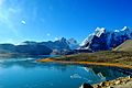
Gurudongmar Lake in Sikkim


See also
 In Spanish: Himalaya para niños
