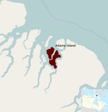
Adams Island (Nunavut) facts for kids
|
Native name:
Tuujjuk
|
|
|---|---|
 |
|
| Geography | |
| Location | Baffin Bay |
| Coordinates | 71°27′N 073°05′W / 71.450°N 73.083°W |
| Archipelago | Canadian Arctic Archipelago |
| Area | 267 km2 (103 sq mi) |
| Length | 30.5 km (18.95 mi) |
| Width | 18–22 km (11–14 mi) |
| Highest elevation | 800 m (2,600 ft) |
| Administration | |
|
Canada
|
|
| Territory | Nunavut |
| Region | Qikiqtaaluk |
| Demographics | |
| Population | Uninhabited |
Adams Island, also known as Tuujjuk in the Inuit language, is an island in Canada. It is a quiet, uninhabited place located in the Arctic. This island is part of the Qikiqtaaluk Region in Nunavut.
Where is Adams Island?
Adams Island is found in Baffin Bay. This bay is off the northeastern coast of Baffin Island. Baffin Island is a very large island in the Canadian Arctic Archipelago.
Nearby places include Dexterity Island to the northeast. Dexterity Fiord and Baffin Island are to the east. Tromso Fiord is to the south, and Paterson Inlet is to the west. You can also find Bergesen Island to the northwest and Isbjorn Strait to the north.
What does Adams Island look like?
Adams Island has an unusual shape. Its eastern and western sides are divided by a part of the sea called the Ratcliffe Arm. The coastlines of the island are very steep.
The mountains inside the island are quite tall. They reach over 800 m (2,600 ft) (about 2,625 feet) in height. The island covers an area of 267 km2 (103 sq mi) (about 103 square miles). It is about 30.55 kilometres (18.98 mi) (19 miles) long. Its width varies from 18 kilometres (11 mi) (11 miles) to 22 kilometres (14 mi) (14 miles).
There is also another, much smaller, Adams Island. This other island is located near the northeastern tip of Baffin Island.
See also
 In Spanish: Isla Adams (Nunavut) para niños


