Afon Dulas, Llanidloes facts for kids
Quick facts for kids Afon Dulas |
|
|---|---|

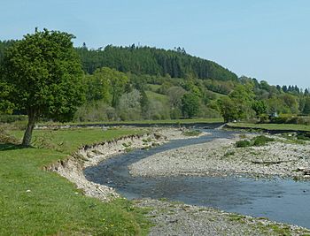
Afon Dulas near to its confluence with the River Severn
|
|
| Country | Wales |
| Region | Powys |
| Physical characteristics | |
| River mouth | River Severn near Llanidloes 52°26′33″N 3°33′07″W / 52.4424°N 3.5519°W |
| Basin features | |
| Basin size | 64.4 km2 (24.9 sq mi) |
The Afon Dulas is a river in Powys, Wales. (Afon is the Welsh word for river). It's like a smaller stream that feeds into a bigger river. The Afon Dulas is one of the main streams that forms the start of the River Severn. It meets the River Severn near a town called Llanidloes. Another river, the Afon Clywedog, joins the Severn at the same spot. The Afon Brochan is the biggest stream that flows into the Afon Dulas. Together, the Dulas and Brochan rivers are about 19.6 kilometers (12 miles) long. Other smaller streams that join the Dulas include Nant Cydros, the Rhydyclwydau Brook, and Nant Gynwydd.
Contents
Where Does the Afon Dulas Flow?
The Afon Dulas starts in a place called Cwm y Saeson. It flows east, passing by Cefn Llech and then Sychnant. At Sychnant, another stream called the Full Brook joins it.
After this, the river turns north. It goes past a shallow crossing point called a ford, at Rhyd Myheryn in Glanyrafon. Here, the Rhydyclwydau Brook flows into the Dulas from its right side.
Following the Old Railway Line
An old railway path, from the Mid-Wales Railway, runs alongside the Dulas from this point. It follows the river's valley all the way to where the Llanidloes railway station used to be.
The Dulas continues flowing towards the north-west. It passes the village of Tylwch. After Tylwch, the river goes through a narrow, rocky section. This part is known as a gorge.
Kayaking in the Gorge
This rocky gorge has been used by whitewater kayakers. These are people who paddle small boats down fast-moving rivers. However, fallen trees in the gorge can make it tricky and dangerous for kayakers.
At Rhos-y-pentref, the river is measured to check its flow. Here, the Nant Gynwydd stream joins the Dulas. The main A470 road also crosses the river at this spot.
The river then turns north again. It flows past Upper Glandulas. This is where its very last tributary, the Afon Brochan, joins it. Finally, the Afon Dulas meets the River Severn. This happens to the south-west of Llanidloes, in an area called Felindre.
How Much Water Does the River Carry?
The amount of water flowing in the Afon Dulas has been measured since 1969. This measurement happens at a special device called a flume. It is located in the lower part of the river, at Rhos-y-pentref.
This long-term record shows that the area of land that collects water for the river, called the catchment area, is about 52.7 square kilometers (20.3 square miles) up to the measuring station. On average, the river carries about 1.4 cubic meters (49 cubic feet) of water per second.
River Levels and Rainfall
The highest river level ever recorded at this station was in October 1998. The water reached a height of 2.4 meters (7.9 feet) through the flume. This meant the river was flowing very fast, carrying about 47 cubic meters (1,659 cubic feet) of water per second.
The Dulas catchment area gets a lot of rain every year. The average annual rainfall is about 1,269 millimeters (50 inches). The highest point in this area is Crugyn Llwyd hill, which is 571 meters (1,873 feet) high. This hill is on the eastern edge of the watershed, near the Pegwn Mawr windfarm. Most of the land in the river's basin is used for pasture (grazing animals), forests, and open moorland.
Images for kids
 | Laphonza Butler |
 | Daisy Bates |
 | Elizabeth Piper Ensley |


