Ahaura facts for kids
Quick facts for kids
Ahaura
|
|
|---|---|

Ahaura River Bridge
|
|
| Country | New Zealand |
| Region | West Coast |
| District | Grey District |
| Ward | Eastern |
| Electorates |
|
| Area | |
| • Total | 0.39 km2 (0.15 sq mi) |
| Population
(June 2023)
|
|
| • Total | 110 |
| • Density | 282/km2 (730/sq mi) |
| Local iwi | Ngāi Tahu |
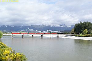
Ahaura is a small town in the West Coast area of New Zealand's South Island. It is located where the Ahaura River flows into the Grey River. Important roads and railway lines pass through the town.
State Highway 7 and the Stillwater–Ngākawau railway line are found here. The city of Greymouth is about 34 kilometers (21 miles) to the south-west. Reefton is about 44 kilometers (27 miles) to the north-east.
European settlers first arrived in this area around 1858. At one point, Ahaura was a busy town. It had six hotels, two butcher shops, a bakery, a blacksmith's shop, and even a printing office.
Contents
People and Place
Ahaura is considered a rural settlement by Statistics New Zealand. It covers an area of about 0.39 square kilometers (0.15 square miles).
Population Changes
The estimated population of Ahaura was 110 as of June 2023, . This means there are about 282 people living in each square kilometer.
| Historical population for Ahaura | ||
|---|---|---|
| Year | Pop. | ±% p.a. |
| 2006 | 111 | — |
| 2013 | 96 | −2.05% |
| 2018 | 96 | +0.00% |
In 2018, Ahaura had 96 people, which was the same as in 2013. This was a small decrease from 2006. There were 45 homes in the town. For every 100 females, there were about 146 males.
The average age of people in Ahaura was 52.5 years old. About 12.5% of the people were under 15 years old.
Who Lives Here?
Most people in Ahaura, about 96.9%, are of European or Pākehā background. About 3.1% are Māori.
When asked about their religion, many people (43.8%) said they had no religion. About 50.0% were Christian.
Climate and Weather
Ahaura is located in the central Grey Valley, about 80 meters (262 feet) above sea level. The climate here is called Oceanic. This means it has mild temperatures and rainfall throughout the year.
The nearby Paparoa Range mountains protect Ahaura from strong sea breezes in summer. In winter, cold air from the mountains can cause more frosts than in nearby Greymouth. Ahaura also usually gets less rain than places closer to the coast because of the mountains.
| Climate data for Totara Flat, 77 m (8km NE of Ahaura) (1971–2000) | |||||||||||||
|---|---|---|---|---|---|---|---|---|---|---|---|---|---|
| Month | Jan | Feb | Mar | Apr | May | Jun | Jul | Aug | Sep | Oct | Nov | Dec | Year |
| Mean daily maximum °C (°F) | 22.1 (71.8) |
22.5 (72.5) |
20.7 (69.3) |
17.4 (63.3) |
13.7 (56.7) |
10.7 (51.3) |
10.7 (51.3) |
12.4 (54.3) |
14.5 (58.1) |
16.5 (61.7) |
18.5 (65.3) |
20.5 (68.9) |
16.7 (62.1) |
| Daily mean °C (°F) | 16.3 (61.3) |
16.4 (61.5) |
14.9 (58.8) |
11.9 (53.4) |
8.8 (47.8) |
6.2 (43.2) |
5.7 (42.3) |
7.2 (45.0) |
9.4 (48.9) |
11.4 (52.5) |
13.2 (55.8) |
15.1 (59.2) |
11.4 (52.5) |
| Mean daily minimum °C (°F) | 10.6 (51.1) |
10.3 (50.5) |
9.0 (48.2) |
6.3 (43.3) |
3.9 (39.0) |
1.7 (35.1) |
0.8 (33.4) |
2.0 (35.6) |
4.4 (39.9) |
6.3 (43.3) |
8.0 (46.4) |
9.6 (49.3) |
6.1 (43.0) |
| Average rainfall mm (inches) | 150.8 (5.94) |
101.0 (3.98) |
125.1 (4.93) |
152.9 (6.02) |
218.2 (8.59) |
155.5 (6.12) |
183.7 (7.23) |
134.8 (5.31) |
180.7 (7.11) |
190.4 (7.50) |
159.3 (6.27) |
183.0 (7.20) |
1,935.4 (76.20) |
| Source: cliflo.niwa.co.nz | |||||||||||||
Nelson Creek Area
Ahaura is part of a larger area called Nelson Creek. This area covers about 897.84 square kilometers (346.66 square miles). As of June 2023, , the estimated population for Nelson Creek was 770.
| Historical population for Nelson Creek | ||
|---|---|---|
| Year | Pop. | ±% p.a. |
| 2006 | 717 | — |
| 2013 | 714 | −0.06% |
| 2018 | 669 | −1.29% |
In 2018, the Nelson Creek area had 669 people. This was a small decrease from 2013 and 2006. There were 276 homes in the area. For every 100 females, there were about 130 males.
The average age in the Nelson Creek area was 45.2 years old. About 17.9% of the people were under 15 years old.
Most people in Nelson Creek (94.2%) are of European or Pākehā background. About 10.8% are Māori. Some people also identify with other ethnic groups.
Education
Awahono School – Grey Valley is a school for students in years 1 to 8 (ages 5-13). It has 84 students as of February 2024. . This school was created in 2005. It brought together students from Ahaura, Moonlight, Ngahere, and Totara Flat schools.
See also
 In Spanish: Ahaura para niños
 | Roy Wilkins |
 | John Lewis |
 | Linda Carol Brown |


