Almeida, Boyacá facts for kids
Quick facts for kids
Almeida, Boyacá
|
||
|---|---|---|
|
Municipality and town
|
||
 |
||
|
||

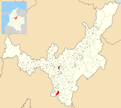
Location of the municipality and town of Almeida, Boyacá in the Boyacá Department of Colombia.
|
||
| Country | ||
| Department | Boyacá Department | |
| Time zone | UTC-5 (Colombia Standard Time) | |
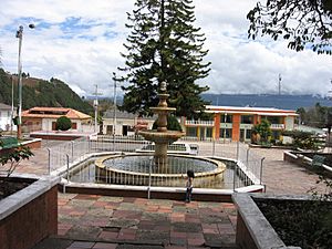
Almeida is a town and municipality in Boyacá Department, Colombia. It is part of the Eastern Boyacá Province. Almeida is a cool place to learn about Colombian culture and geography.
Contents
Where is Almeida Located?
Almeida is surrounded by other towns. Knowing its neighbors helps you understand where it is on a map.
Neighboring Municipalities
- North: Somondoco, Garagoa, and Macanal
- West: Somondoco
- South: Chivor, Macanal, Somondoco (all in Boyacá), and Ubalá (in Cundinamarca)
- East: Macanal and Chivor
Fun Facts About Almeida
Here are some interesting facts about Almeida. They tell us more about daily life and the town's history.
Market Day Fun
Every Sunday, people in Almeida gather for Market Day. This is a special time when locals buy and sell goods. It's a lively event for the community.
How Far is Almeida?
Almeida is about 125 kilometers (78 miles) away from Tunja. Tunja is the capital city of the Boyacá Department.
How High is Almeida?
The town of Almeida is located at an elevation of 2,200 meters (7,218 feet) above sea level. This means it's quite high up in the mountains!
How Big is Almeida?
Almeida covers an area of 57 square kilometers (22 square miles). That's how much land the municipality takes up.
What's the Weather Like?
The average temperature in Almeida is around 19 °C (66 °F). This makes for a mild and pleasant climate most of the time.
When Was Almeida Founded?
Almeida was officially founded on September 24, 1907. This date marks when the town began to grow and develop.
What are People from Almeida Called?
People who live in Almeida are called Almeidunos. This is a special name for the town's residents.
See also
 In Spanish: Almeida (Boyacá) para niños
 | Bayard Rustin |
 | Jeannette Carter |
 | Jeremiah A. Brown |


