Altötting (district) facts for kids
Quick facts for kids
Altötting
|
||
|---|---|---|
|
||
| Country | ||
| State | Bavaria | |
| Adm. region | Upper Bavaria | |
| Region | Südostoberbayern | |
| Capital | Altötting | |
| Area | ||
| • Total | 569.41 km2 (219.85 sq mi) | |
| Population
(2013)
|
||
| • Total | 106,965 | |
| • Density | 187.8523/km2 (486.535/sq mi) | |
| Time zone | UTC+1 (CET) | |
| • Summer (DST) | UTC+2 (CEST) | |
| Vehicle registration | AÖ | |
| Website | http://www.lra-aoe.de | |
Altötting is a special kind of area in Bavaria, Germany, called a Landkreis. You can think of a Landkreis as being similar to a county in other countries. It's a region that groups together several towns and villages.
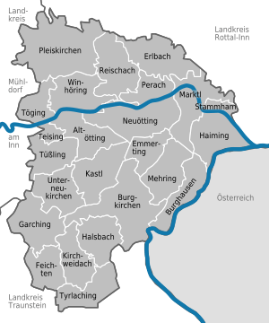
The main town and capital of this district is also named Altötting. The Altötting district is located right next to the border of Austria. A big river called the Inn River flows through the district from the west to the east.
Contents
Exploring Altötting District
The Altötting district is part of the larger region of Upper Bavaria. It covers an area of about 569 square kilometers. In 2013, around 106,965 people lived in this district.
What is a Landkreis?
A Landkreis is an important part of how Germany is organized. It helps manage things like schools, roads, and public services for the towns and villages within its borders. It's a way to make sure local communities work well together.
Geography of the District
The Altötting district has a varied landscape. The Inn River is a major feature, shaping the land and providing natural beauty. Being close to the Austrian border means it's in a scenic part of southern Germany.
Towns and Municipalities
The Altötting district is made up of several towns and smaller communities called municipalities. Each of these places has its own local government, but they also work together as part of the larger district.
Here are the main towns and municipalities in the Altötting district:
| Towns | Municipalities | |
|---|---|---|
|
|
|
See also
 In Spanish: Distrito de Altötting para niños
 | Bayard Rustin |
 | Jeannette Carter |
 | Jeremiah A. Brown |


