
Andahuaylas facts for kids
Quick facts for kids
Andahuaylas
Antawaylla
San Pedro de Andahuaylas
|
|||
|---|---|---|---|

Panorama
|
|||
|
|||

Andahuaylas
Location in Peru
|
|||
| Country | |||
| Region | Apurímac | ||
| Province | Andahuaylas | ||
| Area | |||
| • Total | 370.03 km2 (142.87 sq mi) | ||
| Elevation | 2,926 m (9,600 ft) | ||
| Population
(2017)
|
|||
| • Total | 42,268 | ||
| • Estimate
(2015)
|
63,654 | ||
| Time zone | UTC-5 (PET) | ||
| • Summer (DST) | UTC-5 (PET) | ||
| Area code(s) | 83 | ||
| Website | www.andahuaylas.com | ||


Andahuaylas is a city in Peru. It is the main city of the Andahuaylas Province. This province is part of the Apurímac Region. The city was founded in 1533. Its full original name was San Pedro de Andahuaylas «La Grande de la Corona». This means "The Grand City of the Crown" in Spanish.
The name Andahuaylas comes from the Quechua language. Antawaylla means "copper meadow." The city is also known as the pradera de los celajes. This Spanish phrase means "prairie of colored clouds." About 42,268 people lived there in 2017. This makes it the largest city in its region.
Contents
Exploring Andahuaylas: Location and Climate
Andahuaylas is located in the western part of the Apurímac Region in Peru. The city of Abancay is the closest major city to Andahuaylas.
Weather in Andahuaylas: What to Expect
The weather in Andahuaylas is generally mild. It has warm days and cool nights. The city gets most of its rain during the summer months. This is from December to March. The dry season is from May to August. The average temperature stays fairly steady throughout the year.
| Climate data for Andahuaylas, elevation 2,981 m (9,780 ft), (1991–2020) | |||||||||||||
|---|---|---|---|---|---|---|---|---|---|---|---|---|---|
| Month | Jan | Feb | Mar | Apr | May | Jun | Jul | Aug | Sep | Oct | Nov | Dec | Year |
| Mean daily maximum °C (°F) | 20.2 (68.4) |
19.8 (67.6) |
19.7 (67.5) |
20.1 (68.2) |
20.4 (68.7) |
19.8 (67.6) |
19.5 (67.1) |
20.0 (68.0) |
20.6 (69.1) |
21.4 (70.5) |
22.3 (72.1) |
21.2 (70.2) |
20.4 (68.8) |
| Mean daily minimum °C (°F) | 9.4 (48.9) |
9.6 (49.3) |
9.2 (48.6) |
7.7 (45.9) |
5.1 (41.2) |
4.2 (39.6) |
3.7 (38.7) |
5.0 (41.0) |
7.0 (44.6) |
8.0 (46.4) |
8.5 (47.3) |
9.3 (48.7) |
7.2 (45.0) |
| Average precipitation mm (inches) | 131.9 (5.19) |
128.5 (5.06) |
103.8 (4.09) |
38.4 (1.51) |
17.0 (0.67) |
7.2 (0.28) |
11.3 (0.44) |
17.9 (0.70) |
26.4 (1.04) |
48.0 (1.89) |
50.1 (1.97) |
92.8 (3.65) |
673.3 (26.49) |
| Source: National Meteorology and Hydrology Service of Peru | |||||||||||||
Getting Around: Transportation in Andahuaylas
Andahuaylas has its own airport. It is called the Andahuaylas Airport. This airport helps people travel to and from the city.
Images for kids
-
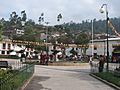
Central square of Andahuaylas
-
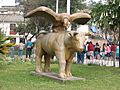
Statue on central square
-

Mototaxis on the central square


See also
 In Spanish: Andahuaylas para niños
