
Anguil facts for kids
Quick facts for kids
Anguil
|
|
|---|---|
|
Rural locality and village
|
|
 |
|
| Country | |
| Province | |
| Department | Capital |
| Area | |
| • Total | 850 km2 (330 sq mi) |
| Elevation | 152 m (499 ft) |
| Population
(2001)
|
|
| • Total | 1,630 |
| Time zone | UTC−3 (ART) |
| Postal code |
L6326
|
| Area code(s) | 02954 |
Anguil is a small village and rural area in La Pampa Province, Argentina. It's about 26 kilometers (16 miles) from the city of Santa Rosa, right next to National Route 5. In 2001, about 1,630 people lived there.
Contents
What Does the Name Anguil Mean?
The name Anguil comes from the Mapudungun language. Some people believe it means "lands of olivillo" or "olivillo-olivillo." The olivillo is a plant common in the area. Its leaves give the fields a silvery color.
However, another expert, Enrique Stieben, thought it meant "dry calden" or "dry bush." The calden is a type of tree found in the region.
The Story of Anguil: How It Began
Anguil officially started on December 2, 1906. It was founded by Eduardo and Alberto Castex, a father and son. They gave land for important public places. These included the town square, the City Hall, the Police Station, and the church. They also donated land for Italian and Spanish community centers.
The Castex family also helped people settle in the area. They divided up their land near the new railway station. They offered easy payment plans for families to buy this land. This helped hundreds of families move to Anguil.
In 2006, the town celebrated its 100th birthday! Anguil is the only other town besides Santa Rosa in the Capital Department. A railway line passed through Anguil starting in 1897, even before the town was officially founded. For a long time, Anguil got its water from a special tank.
Anguil's Agricultural Research Center (INTA)
Near Anguil, there is an important place called the Anguil Agricultural Experimental Station. It started working in 1954. This station helps farmers in the region. It teaches them about new plants, like weeping lovegrass, and good ways to take care of the land.
In 1956, it became part of the National Institute of Agricultural Technology (INTA). In 1996, it was renamed after its first director, Guillermo Covas.
In 2008, a special weather radar was set up here. This radar helps predict the weather and is part of Argentina's Civil Defense System. It can see weather up to 480 kilometers (about 300 miles) away.
Anguil's Weather
Anguil has different seasons, like many places. Here's a quick look at its climate:
- Warmest Months: January and December are the warmest, with average temperatures around 23°C (73°F).
- Coolest Months: July and June are the coolest, with average temperatures around 7-8°C (45-46°F).
- Rainfall: The wettest months are usually March, January, and February. June and July are the driest.
- Sunny Days: Anguil gets a good amount of sunshine throughout the year, especially in summer.
| Climate data for Anguil (1973–2016) | |||||||||||||
|---|---|---|---|---|---|---|---|---|---|---|---|---|---|
| Month | Jan | Feb | Mar | Apr | May | Jun | Jul | Aug | Sep | Oct | Nov | Dec | Year |
| Record high °C (°F) | 44.5 (112.1) |
39.6 (103.3) |
37.8 (100.0) |
35.5 (95.9) |
30.8 (87.4) |
25.7 (78.3) |
27.3 (81.1) |
34.0 (93.2) |
34.0 (93.2) |
36.6 (97.9) |
38.0 (100.4) |
41.2 (106.2) |
44.5 (112.1) |
| Mean daily maximum °C (°F) | 30.6 (87.1) |
29.2 (84.6) |
26.6 (79.9) |
22.6 (72.7) |
18.1 (64.6) |
14.9 (58.8) |
14.5 (58.1) |
17.3 (63.1) |
19.9 (67.8) |
22.8 (73.0) |
26.4 (79.5) |
29.6 (85.3) |
22.6 (72.7) |
| Daily mean °C (°F) | 23.0 (73.4) |
21.7 (71.1) |
19.5 (67.1) |
15.3 (59.5) |
11.3 (52.3) |
8.0 (46.4) |
7.4 (45.3) |
9.5 (49.1) |
12.2 (54.0) |
15.6 (60.1) |
18.9 (66.0) |
21.9 (71.4) |
15.4 (59.7) |
| Mean daily minimum °C (°F) | 15.2 (59.4) |
14.0 (57.2) |
12.2 (54.0) |
8.1 (46.6) |
4.5 (40.1) |
1.3 (34.3) |
0.5 (32.9) |
1.8 (35.2) |
4.2 (39.6) |
8.0 (46.4) |
10.9 (51.6) |
14.0 (57.2) |
7.9 (46.2) |
| Record low °C (°F) | 1.5 (34.7) |
1.5 (34.7) |
−2.0 (28.4) |
−9.1 (15.6) |
−10.5 (13.1) |
−11.2 (11.8) |
−13.2 (8.2) |
−11.2 (11.8) |
−10.5 (13.1) |
−4.8 (23.4) |
−2.9 (26.8) |
1.5 (34.7) |
−13.2 (8.2) |
| Average precipitation mm (inches) | 98.3 (3.87) |
92.3 (3.63) |
107.3 (4.22) |
62.4 (2.46) |
31.5 (1.24) |
19.6 (0.77) |
20.9 (0.82) |
25.5 (1.00) |
47.7 (1.88) |
86.7 (3.41) |
81.1 (3.19) |
96.2 (3.79) |
769.5 (30.30) |
| Average precipitation days | 8 | 7 | 7 | 6 | 5 | 4 | 4 | 3 | 5 | 9 | 7 | 8 | 71 |
| Average relative humidity (%) | 59 | 64 | 68 | 70 | 74 | 74 | 72 | 64 | 61 | 63 | 58 | 56 | 65 |
| Mean monthly sunshine hours | 294.5 | 251.4 | 232.5 | 180.0 | 145.7 | 123.0 | 139.5 | 170.5 | 189.0 | 223.2 | 267.0 | 291.4 | 2,507.7 |
| Percent possible sunshine | 67 | 66 | 61 | 54 | 46 | 42 | 46 | 51 | 53 | 55 | 63 | 65 | 57 |
| Source: Instituto Nacional de Tecnología Agropecuaria | |||||||||||||
Schools in Anguil
Anguil has good schools for its young people:
- School No. 39 Nicolás Avellaneda: This school opened in 1909. It has classes in the morning and evening.
- Enrique Stieben High School: This high school started in 1988. About 60 students attend classes here in the mornings. It focuses on Humanities and Social Sciences.
- There are also other learning programs offered by local groups.
Sports and Clubs
Sports are important in Anguil!
- In 1934, the Club Anguilense was formed.
- Later, in 1964, the Club Ferro was created.
- Eventually, Club Anguilense and Unión Italiana joined together. They formed the Centro Social y Deportivo (Social and Sports Center) that exists today.
Images for kids
-
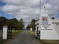
The entrance to the Anguil Agricultural Experimental Station.
See also
 In Spanish: Anguil para niños
