
Santa Rosa, La Pampa facts for kids
Quick facts for kids
Santa Rosa
|
|
|---|---|

Panoramic of Santa Rosa
|
|

Santa Rosa
Location in Argentina

Santa Rosa
Location in La Pampa Province
|
|
| Country | |
| Province | |
| Department | Capital |
| Founded | 22 April 1892 |
| Area | |
| • City | 1,500 km2 (600 sq mi) |
| Elevation | 175 m (574 ft) |
| Population
(2010 census)
|
|
| • Urban | 102,880 |
| Time zone | UTC−3 (ART) |
| Postal code |
L6300
|
| Phone code | +54 2954 |
| Website | www.santarosa.gov.ar |
Santa Rosa is a city in Argentina. It's the capital of the La Pampa Province. You can find it in the eastern part of the province, right by the Don Tomás Lagoon. It's also where two important roads, National Routes 5 and 35, meet.
In 2010, the city of Santa Rosa had about 102,880 people living there. If you include the nearby city of Toay, the total population for the area was around 124,101. This means about one-third of all the people in La Pampa Province live here! The current mayor of Santa Rosa is Luciano di Nápoli.
Santa Rosa was started in 1892 by a person named Tomás Mason. For a long time, it was a small town. It only really grew into an important farming area in the second half of the 1900s. Even today, it's one of the smaller provincial capitals in Argentina.
Contents
What to See in Santa Rosa
Santa Rosa has some cool places to visit:
- The Fitte neighborhood, built in the 1930s.
- A monument honoring José de San Martín, a very important hero in Argentine history.
- The Palace of Justice, which is an important government building.
- The Teatro Español Theatre, a historic theater built in 1908.
- The Provincial Art Museum, where you can see amazing paintings by famous Argentine artists like Raúl Soldi and Antonio Berni.
- The Provincial Natural History Museum, which teaches you about the local plants and animals.
The Santa Rosa Airport is just 2 kilometers from the city. You can catch regular flights from here to Buenos Aires.
Geography of Santa Rosa

Santa Rosa is located on the western edge of the Argentine Pampas. The Pampas are like huge, flat grasslands. Santa Rosa is special because it's where these flat plains start to become more hilly.
The city is built around the Don Tomás Lagoon. This lagoon collects rainwater from the areas nearby. The main part of the city is on higher ground to the west of the lagoon. There are small hills and plateaus, with some areas being quite steep.
Santa Rosa's Climate
Santa Rosa has a humid subtropical climate. This means it has warm to hot summers. The winters are usually chilly and dry.
The hottest temperature ever recorded in Santa Rosa was 45.7°C (114.3°F) on January 6, 1955. The coldest temperature ever was -12.7°C (9.1°F) on June 13, 1967.
| Climate data for Santa Rosa (1991–2020, extremes 1902–present) | |||||||||||||
|---|---|---|---|---|---|---|---|---|---|---|---|---|---|
| Month | Jan | Feb | Mar | Apr | May | Jun | Jul | Aug | Sep | Oct | Nov | Dec | Year |
| Record high °C (°F) | 45.7 (114.3) |
42.2 (108.0) |
39.7 (103.5) |
36.5 (97.7) |
31.8 (89.2) |
27.1 (80.8) |
27.8 (82.0) |
34.4 (93.9) |
35.2 (95.4) |
38.4 (101.1) |
39.9 (103.8) |
42.8 (109.0) |
45.7 (114.3) |
| Mean daily maximum °C (°F) | 31.5 (88.7) |
29.9 (85.8) |
27.3 (81.1) |
22.7 (72.9) |
18.2 (64.8) |
15.1 (59.2) |
14.5 (58.1) |
17.6 (63.7) |
20.3 (68.5) |
23.0 (73.4) |
27.1 (80.8) |
30.3 (86.5) |
23.1 (73.6) |
| Daily mean °C (°F) | 23.8 (74.8) |
22.2 (72.0) |
19.7 (67.5) |
15.2 (59.4) |
11.3 (52.3) |
8.1 (46.6) |
7.4 (45.3) |
9.6 (49.3) |
12.5 (54.5) |
15.8 (60.4) |
19.6 (67.3) |
22.7 (72.9) |
15.7 (60.3) |
| Mean daily minimum °C (°F) | 16.5 (61.7) |
15.2 (59.4) |
13.4 (56.1) |
9.5 (49.1) |
6.1 (43.0) |
3.0 (37.4) |
2.1 (35.8) |
3.5 (38.3) |
5.9 (42.6) |
9.2 (48.6) |
12.4 (54.3) |
15.2 (59.4) |
9.3 (48.7) |
| Record low °C (°F) | 0.9 (33.6) |
2.3 (36.1) |
−3.7 (25.3) |
−7.0 (19.4) |
−8.6 (16.5) |
−12.7 (9.1) |
−12.3 (9.9) |
−10.0 (14.0) |
−8.8 (16.2) |
−4.3 (24.3) |
−1.2 (29.8) |
2.0 (35.6) |
−12.7 (9.1) |
| Average precipitation mm (inches) | 95.3 (3.75) |
88.3 (3.48) |
99.0 (3.90) |
63.8 (2.51) |
32.1 (1.26) |
17.3 (0.68) |
18.8 (0.74) |
26.9 (1.06) |
49.7 (1.96) |
90.2 (3.55) |
75.9 (2.99) |
96.1 (3.78) |
753.4 (29.66) |
| Average precipitation days (≥ 0.1 mm) | 8.3 | 7.2 | 7.2 | 6.1 | 4.7 | 4.2 | 4.3 | 3.5 | 5.3 | 8.3 | 7.6 | 8.0 | 74.7 |
| Average snowy days | 0.0 | 0.0 | 0.0 | 0.0 | 0.0 | 0.0 | 0.1 | 0.1 | 0.0 | 0.0 | 0.0 | 0.0 | 0.1 |
| Average relative humidity (%) | 57.1 | 62.9 | 68.4 | 70.7 | 75.8 | 73.6 | 70.2 | 62.7 | 60.0 | 62.1 | 56.5 | 53.3 | 64.4 |
| Mean monthly sunshine hours | 306.9 | 248.6 | 226.3 | 183.0 | 151.9 | 132.0 | 145.7 | 179.8 | 180.0 | 210.8 | 279.0 | 297.6 | 2,541.6 |
| Mean daily sunshine hours | 9.9 | 8.8 | 7.3 | 6.1 | 4.9 | 4.4 | 4.7 | 5.8 | 6.0 | 6.8 | 9.3 | 9.6 | 7.0 |
| Percent possible sunshine | 71 | 68 | 59 | 59 | 50 | 45 | 47 | 54 | 53 | 56 | 65 | 67 | 58 |
| Source 1: Servicio Meteorológico Nacional | |||||||||||||
| Source 2: NOAA (percent sun 1961–1990) Meteo Climat (record highs and lows), | |||||||||||||
Sports in Santa Rosa
Santa Rosa is home to several football (soccer) teams. Some of the main ones are:
- Club Atlético Santa Rosa
- Club Atlético All Boys
- Club Atlético Belgrano
Images for kids
-
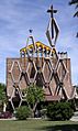
Church in Santa Rosa, Argentina.
-
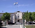
Municipal Building, Santa Rosa, Argentina.
-
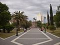
Monument to José de San Martín, Santa Rosa.


See also
 In Spanish: Santa Rosa (La Pampa) para niños
