Aorangaia Island facts for kids

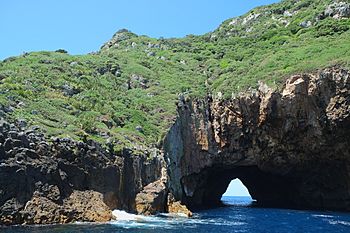
Rock tunnel in Aorangaia Island
|
|
| Geography | |
|---|---|
| Location | Northland Region |
| Coordinates | 35°29′10″S 174°44′48″E / 35.4862°S 174.7466°E |
| Highest elevation | 102 m (335 ft) |
| Administration | |
| Demographics | |
| Population | 0 |
Aorangaia Island is a small island located in the Northland Region of New Zealand. It is part of a special group of islands called the Poor Knights Islands. This island reaches a highest point of 102 metres (about 335 feet) above sea level. It is located about 21 kilometres (13 miles) away from the main coast of New Zealand.
Contents
What is Aorangaia Island?
Aorangaia Island is one of the many islands that make up the Poor Knights Islands. These islands are known for their amazing natural beauty and unique wildlife. Aorangaia Island itself is not lived on by people. It is a wild and untouched place.
Where is Aorangaia Island Located?
Aorangaia Island is found off the coast of the Northland Region in the northern part of New Zealand. It is part of the Whangarei District. The island is quite far from the mainland, which helps keep its natural environment safe.
How High is Aorangaia Island?
The highest point on Aorangaia Island is 102 metres (335 feet) tall. This makes it a noticeable landmark among the other islands in the group. The island's rocky cliffs rise steeply from the ocean.
The Poor Knights Islands: A Special Place
Aorangaia Island is part of the Poor Knights Islands. This entire group of islands is very important for nature. They are a protected marine reserve and a nature reserve. This means the land and the waters around them are carefully looked after.
How Were the Islands Formed?
The Poor Knights Islands, including Aorangaia, were formed by volcanoes a very long time ago. Over millions of years, the volcanoes became extinct. Then, the land was shaped by wind and waves. This created the steep cliffs, sea caves, and arches we see today. The rock tunnel shown in the image is an example of this natural shaping.
A Protected Marine Reserve
The waters around the Poor Knights Islands are a marine reserve. This is like a national park, but for the ocean. It means that fishing and taking anything from the sea are not allowed. This protection helps marine life to thrive.
What Lives in the Marine Reserve?
The marine reserve is home to many different kinds of sea creatures. You can find colourful fish, bright corals, and even sharks and stingrays. Divers from all over the world come here to explore the underwater world. The clear waters make it a great place for snorkeling too.
Wildlife on the Islands
The islands themselves are also protected nature reserves. This means no one can live on them. It also means that many rare plants and animals can live there safely.
Unique Plants and Birds
The islands have plants that are found nowhere else in the world. Many seabirds also nest on the cliffs. These birds include shearwaters and petrels. The islands provide a safe place for them to raise their young.
Home of the Tuatara
The Poor Knights Islands are one of the few places where the tuatara still lives in the wild. The tuatara is a reptile that looks like a lizard. It is very ancient and has been around for millions of years. Protecting these islands helps protect the tuatara.
Why is Aorangaia Island Uninhabited?
Aorangaia Island, like the other Poor Knights Islands, has no people living on it. This is because the islands are protected. They are kept wild to preserve their unique plants and animals. Access to the islands is very limited and requires special permission. This helps keep the environment safe and undisturbed.
See also
 In Spanish: Isla Aorangaia para niños
 | James Van Der Zee |
 | Alma Thomas |
 | Ellis Wilson |
 | Margaret Taylor-Burroughs |

