Appleby, New Zealand facts for kids
Quick facts for kids
Appleby
|
|
|---|---|
|
Locality
|
|

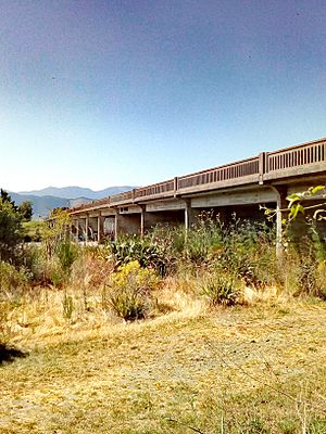
Appleby Bridge
|
|
| Country | New Zealand |
| Territorial authority | Tasman |
| Ward | Richmond Ward |
| Electorates |
|
| Area | |
| • Total | 20.50 km2 (7.92 sq mi) |
| Population
(June 2023)
|
|
| • Total | 790 |
| • Density | 38.54/km2 (99.8/sq mi) |
| Time zone | UTC+12 (NZST) |
| • Summer (DST) | UTC+13 (NZDT) |
| Area code | 03 |
Appleby is a small community in the Tasman district of New Zealand. It is located on the South Island, close to the Waimea River and Tasman Bay / Te Tai-o-Aorere. People first settled here in the early 1840s. State Highway 60, an important road, goes right through Appleby.
Historic Buildings in Appleby
Appleby has several buildings that are important for their history. These buildings are officially protected by Heritage New Zealand. This means they are special and need to be looked after.
- Springfield: This is a house found at the corner of State Highway 60 and Cotterill Road. It is listed as a Category II historic place.
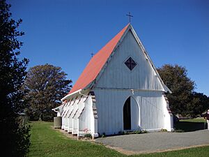
- St Alban's Church: This church is also on State Highway 60. It is a Category II historic place.
- Stafford Place: Located at 61 Redwood Road, this building is a Category I historic place. This means it is very important to New Zealand's history.
- Redwood Racing Stables: These stables used to belong to Stafford Place. They were moved to Richmond and are also a Category I historic place.
Appleby's Population
The Appleby area covers about 20.50 square kilometers. As of July 2025, about 790 people live here. This means there are about 39 people living in each square kilometer.
The population of Appleby has changed over the years. In 2006, there were 744 people. By 2013, the population grew to 783. In 2018, it was 786 people. This shows a small increase in the number of residents.
In 2018, there were 261 households in Appleby. There were slightly more males (411) than females (378). The average age of people living in Appleby was 44.2 years. About 18.7% of the people were under 15 years old. Another 18.7% were between 15 and 29 years old. Most people, about 48.5%, were between 30 and 64 years old. About 14.5% were 65 years or older.
Most people in Appleby, about 88.9%, are of European or Pākehā background. About 11.5% are Māori. Smaller groups include Pasifika (4.6%) and Asian (2.3%). Some people identify with more than one ethnic group. About 14.5% of the people in Appleby were born outside New Zealand.
When asked about their religion, most people (57.3%) said they had no religion. About 30.9% were Christian. A small number of people followed other religions like Buddhism.
Education in Appleby
Appleby School is the local primary school. It teaches students from Year 1 to Year 7. As of July 2025, the school has 90 students. The school first opened in 1859. Starting in 2026, the school will also teach Year 8 students.
Appleby's Climate
Appleby has a varied climate. Here is some information about the weather:
| Climate data for Appleby (1991–2020 normals, extremes 1932–present) | |||||||||||||
|---|---|---|---|---|---|---|---|---|---|---|---|---|---|
| Month | Jan | Feb | Mar | Apr | May | Jun | Jul | Aug | Sep | Oct | Nov | Dec | Year |
| Record high °C (°F) | 32.6 (90.7) |
35.7 (96.3) |
29.6 (85.3) |
28.3 (82.9) |
25.0 (77.0) |
20.7 (69.3) |
19.0 (66.2) |
20.0 (68.0) |
24.1 (75.4) |
26.4 (79.5) |
28.6 (83.5) |
30.2 (86.4) |
35.7 (96.3) |
| Mean maximum °C (°F) | 28.7 (83.7) |
27.9 (82.2) |
26.4 (79.5) |
23.3 (73.9) |
21.1 (70.0) |
18.0 (64.4) |
16.7 (62.1) |
18.0 (64.4) |
20.4 (68.7) |
22.7 (72.9) |
24.8 (76.6) |
26.1 (79.0) |
29.4 (84.9) |
| Mean daily maximum °C (°F) | 22.8 (73.0) |
23.0 (73.4) |
21.6 (70.9) |
18.8 (65.8) |
16.4 (61.5) |
13.7 (56.7) |
13.1 (55.6) |
13.9 (57.0) |
15.5 (59.9) |
17.3 (63.1) |
19.1 (66.4) |
21.1 (70.0) |
18.0 (64.4) |
| Daily mean °C (°F) | 16.9 (62.4) |
17.0 (62.6) |
15.3 (59.5) |
12.6 (54.7) |
10.1 (50.2) |
7.6 (45.7) |
6.9 (44.4) |
8.1 (46.6) |
9.9 (49.8) |
11.8 (53.2) |
13.3 (55.9) |
15.7 (60.3) |
12.1 (53.8) |
| Mean daily minimum °C (°F) | 11.0 (51.8) |
11.0 (51.8) |
9.0 (48.2) |
6.4 (43.5) |
3.8 (38.8) |
1.5 (34.7) |
0.7 (33.3) |
2.3 (36.1) |
4.3 (39.7) |
6.3 (43.3) |
7.5 (45.5) |
10.3 (50.5) |
6.2 (43.1) |
| Mean minimum °C (°F) | 5.5 (41.9) |
4.6 (40.3) |
2.8 (37.0) |
0.1 (32.2) |
−2.6 (27.3) |
−4.5 (23.9) |
−4.7 (23.5) |
−3.3 (26.1) |
−1.5 (29.3) |
0.1 (32.2) |
1.7 (35.1) |
4.0 (39.2) |
−5.4 (22.3) |
| Record low °C (°F) | 2.3 (36.1) |
1.0 (33.8) |
0.1 (32.2) |
−1.8 (28.8) |
−7.0 (19.4) |
−11.0 (12.2) |
−9.7 (14.5) |
−7.6 (18.3) |
−3.8 (25.2) |
−2.9 (26.8) |
−1.2 (29.8) |
0.9 (33.6) |
−11.0 (12.2) |
| Average rainfall mm (inches) | 74.1 (2.92) |
66.0 (2.60) |
70.5 (2.78) |
79.0 (3.11) |
86.7 (3.41) |
105.8 (4.17) |
73.5 (2.89) |
77.7 (3.06) |
77.9 (3.07) |
79.6 (3.13) |
68.5 (2.70) |
88.1 (3.47) |
947.4 (37.31) |
| Mean monthly sunshine hours | 269.9 | 240.6 | 226.4 | 194.3 | 177.3 | 148.1 | 161.3 | 181.8 | 194.9 | 237.1 | 245.8 | 246.9 | 2,524.4 |
| Source: NIWA | |||||||||||||
 | Precious Adams |
 | Lauren Anderson |
 | Janet Collins |


