Arjay, Kentucky facts for kids
Quick facts for kids
Arjay, Kentucky
|
|
|---|---|

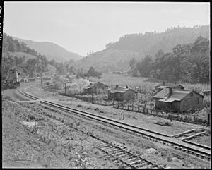
Houses along the railroad track in Arjay, 1946. Photo by Russell Lee.
|
|
| Country | United States |
| State | Kentucky |
| County | Bell |
| Area | |
| • Total | 0.62 sq mi (1.61 km2) |
| • Land | 0.62 sq mi (1.61 km2) |
| • Water | 0.00 sq mi (0.00 km2) |
| Elevation | 1,066 ft (325 m) |
| Population
(2020)
|
|
| • Total | 183 |
| • Density | 295.16/sq mi (113.97/km2) |
| Time zone | UTC-5 (Eastern (EST)) |
| • Summer (DST) | UTC-4 (EDT) |
| ZIP code |
40902
|
| Area code(s) | 606 |
| GNIS feature ID | 486025 |
Arjay is a small community located in Bell County, Kentucky, in the United States. It is an unincorporated community, which means it doesn't have its own local government like a city or town. Arjay is also known as a "coal town" because its history and economy were closely connected to the coal mining industry.
Contents
About Arjay
Where is Arjay Located?
Arjay is found in the eastern part of Kentucky. You can find it about 4 miles (6.4 kilometers) northeast of a town called Pineville. It is located along Kentucky Route 66.
How Arjay Got Its Name
The community of Arjay has a unique name. It comes from the initials of a person named R. J. Asher. He was a coal operator, meaning he was involved in the business of mining coal. The post office in Arjay opened on February 23, 1911. It uses the ZIP code 40902.
People of Arjay
What is the Population of Arjay?
According to the 2020 United States Census, 183 people live in Arjay. This number helps us understand how many residents call this small community home.
 | Kyle Baker |
 | Joseph Yoakum |
 | Laura Wheeler Waring |
 | Henry Ossawa Tanner |


