Arrino, Western Australia facts for kids
Quick facts for kids ArrinoWestern Australia |
|
|---|---|

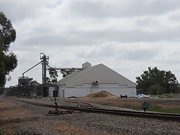
The Arrino grain receival point in August 2022
|
|
| Established | 1904 |
| Postcode(s) | 6519 |
| Elevation | 263 m (863 ft) |
| Area | [convert: needs a number] |
| Location |
|
| LGA(s) | Shire of Three Springs |
| State electorate(s) | Moore |
| Federal Division(s) | Durack |
Arrino is a small town located in the Mid West area of Western Australia. You can find it between the towns of Mingenew and Three Springs, right on the Midlands Road.
Contents
What's in a Name? Arrino's Story
The name Arrino comes from the language of the Aboriginal people. It is the name of the local springs. People believe the name means "place of many granite hills."
The name Arrino first appeared on maps in 1859. It was also the name of a farm started by an early settler, NW Cooke, in 1876. The town itself was officially created in 1904.
Early Days: Schools and Buildings
In 1905, there were plans to build a school and homes for teachers in Arrino. The estimated cost for these buildings was about £325.
Challenges: Floods and Bushfires
Arrino has faced natural challenges over the years.
When Water Rose: The 1932 Flood
In 1932, heavy rain caused the Arrowsmith River and nearby creeks to flood. This happened very quickly, just a few hours after the rain started. A part of the railway line between Arrino and Three Springs was washed away. This meant the train line had to close for several days.
Fire on the Land: Bushfires
Later in 1932, huge bushfires swept through the areas around Arrino. These fires destroyed crops and natural bushland. About 10,000 acres (or 4,000 hectares) of land were burned. More fires started the next year, in 1933. Another 2,000 acres (or 800 hectares) of farmland were lost to the flames.
What Arrino Does: Farming
The main activity in Arrino is wheat farming. The town is an important site for Cooperative Bulk Handling. This means it's a place where farmers bring their harvested grain to be stored and processed.
 | Ernest Everett Just |
 | Mary Jackson |
 | Emmett Chappelle |
 | Marie Maynard Daly |


