
Aruviyodu Village facts for kids
Aruviyodu Village is a small, hilly village located near the Neyyar River in India. It's in the southern part of Kerala state, within the Thiruvananthapuram district. Aruviyodu is part of the Kunnathukal Panchayath and belongs to the South Kerala Division.
This village is about 28 kilometers (17 miles) east of Thiruvananthapuram, which is the main city of the district. It is also just 6 kilometers (3.7 miles) from Perumkadavila. Aruviyodu is surrounded by different areas like Neyyattinkara to the west and Parassala to the south. It's also close to the border between Thiruvananthapuram District and Kanniyakumari District.
Quick Facts About Aruviyodu
Aruviyodu is a part of the Perumkadavila area. Here are some quick facts about the village:
| Fact | Detail |
|---|---|
| District | Thiruvananthapuram |
| State | Kerala |
| Division | South Kerala |
| Main Languages | Malayalam, English, Tamil |
| Area Code | 0471 |
| Pin Code | 695504 |
| Post Office | Karakonam |
| Main Village | Kunnathukal |
Getting Around Aruviyodu
Aruviyodu is connected by railway. The closest train stations are Dhanuvachapuram Railway Station and Amaravila Halt Railway Station. A bigger train station, Trivandrum Central Railway Station, is about 26 kilometers (16 miles) away.
Images for kids
-
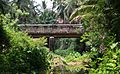
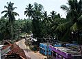
Aruviyodu bridge
-
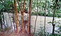
Chittar
-

New Beginning.. From Aruviyodu
-
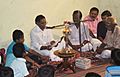
Inauguration of Thalathrayam Library
-
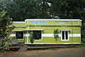
Thalathrayam Library
-
Aruviyodu Village


