Atenguillo facts for kids
Quick facts for kids
Atenguillo
|
||
|---|---|---|
|
Municipality and town
|
||
|
||

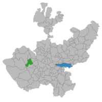
Location of the municipality in Jalisco
|
||
| Country | ||
| State | Jalisco | |
| Area | ||
| • Total | 610.2 km2 (235.6 sq mi) | |
| • Town | 1.16 km2 (0.45 sq mi) | |
| Population
(2020 census)
|
||
| • Total | 4,176 | |
| • Density | 6.8437/km2 (17.725/sq mi) | |
| • Town | 1,589 | |
| • Town density | 1,370/km2 (3,548/sq mi) | |
| Area code(s) | 388 | |
Atenguillo is a town and a municipality in Jalisco, a state in central-western Mexico. A municipality is like a local government area that includes a main town and the smaller communities around it.
Contents
About Atenguillo
Atenguillo is a place in Mexico that includes both a town and the larger area it governs, called a municipality. It is known for its location in the state of Jalisco.
Where is Atenguillo Located?
Atenguillo is found in the western part of Mexico. It is part of the state of Jalisco, which is a well-known state in the country. You can see its location on a map of Jalisco.
How Many People Live in Atenguillo?
According to a count done in 2020, the entire municipality of Atenguillo had a population of 4,176 people. The main town of Atenguillo itself was home to 1,589 people.
What is the Size of Atenguillo?
The total area of the Atenguillo municipality is about 610.2 square kilometers. To give you an idea, the town of Atenguillo itself covers a smaller area of about 1.16 square kilometers.
Important Numbers for Atenguillo
If you ever needed to send mail to Atenguillo, the postal code is 48100. For phone calls, the area code is 388.
See also
 In Spanish: Municipio de Atenguillo para niños


