Atzacan facts for kids
Atzacan is a municipality (like a county) located in the Mexican state of Veracruz. It is about 198 kilometers (123 miles) away from Xalapa, which is the capital city of Veracruz. The area of Atzacan is about 80.61 square kilometers (31.12 square miles). You can find it at these coordinates: 18°54′N 97°05′W / 18.900°N 97.083°W.
Atzacan shares its borders with several other places. To the north, it is next to Chocaman. To the east, it borders Iztaczoquitlán. To the south, you'll find Orizaba, and to the southwest, it's next to Mariano Escobedo. On the west side, it borders La Perla, and to the northwest, it's next to Coscomatepec de Bravo.
Contents
What Atzacan Produces
Farming in Atzacan
The main crops grown in Atzacan are maize (corn) and beans. These are important foods for the people living there. Farmers work hard to grow these crops, which are a big part of the local economy.
Traditions and Celebrations
Santa Ana Festival
A special celebration takes place in Atzacan every April. This festival honors Santa Ana, who is considered the patron saint of the area. During this time, people gather to celebrate with various activities and traditions.
Recent Community Events
Remembering Mayor Octavio Misael Lorenzo Morales
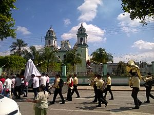
On February 8, 2021, many people gathered for the funeral of Mayor Octavio Misael Lorenzo Morales. He was the mayor of Atzacan and had passed away. A large crowd attended his funeral to show their respect and mourn his loss. This event showed how much the community cared for their leader.
See also
 In Spanish: Municipio de Atzacan para niños
 | May Edward Chinn |
 | Rebecca Cole |
 | Alexa Canady |
 | Dorothy Lavinia Brown |


