Autwine, Oklahoma facts for kids
Quick facts for kids
Autwine, Oklahoma
|
|
|---|---|
| Etymology: Antwine Roy (1848-1911), a Ponca leader | |
| Country | United States |
| State | Oklahoma |
| Founded | 1894 |
| Elevation | 968 ft (295 m) |
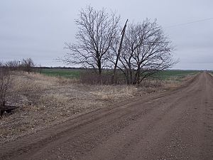
Autwine is a ghost town in Kay County, Oklahoma, United States. A ghost town is a place where people used to live and work, but now almost no one lives there. Autwine was once called Pierceton and Virginia City.
The town got its name from Antoine Roy, a leader of the Ponca Native American group. Autwine had a post office from 1894 until 1922. The town slowly disappeared because better roads meant farmers could travel to bigger towns to do their business. Today, there is nothing left of the old town. The land is now used for farming.
History of Autwine
Autwine was first known as Virginia City. It was officially planned out on June 17, 1899. The town's post office was called Pierceton, and the train station was named Arta. Later, everyone agreed to call the town Autwine.
The town was named after Antwine Roy, a respected leader of the Ponca Nation. There are two stories about why the name became "Autwine" instead of "Antwine." One story says a train agent misspelled the name and refused to fix it. Another story suggests that a town clerk's messy handwriting caused the name to be spelled "Autwine" when it was sent to Washington.
Autwine was an important center for farming. Around the year 1900, the town had many businesses. It had two grain elevators, a place for livestock, and a yard for farm tools. There was also a bank, ten other shops, and a doctor. About 25 homes were in the town itself, with more in the nearby area. Autwine was a regular place for shipping cattle, hogs, and wheat. Famous local ranches like the 101 Ranch, the Little V, and the Big V were nearby. The town also had a school for grades 1-8. Older students went to high school in Blackwell, about six miles away.
Why Autwine Disappeared
Autwine began to decline in the early 1900s. This happened as roads got better. Farmers found it easier to go to larger towns to buy and sell goods.
The town's bank closed in 1904. A big fire in 1905 destroyed most of the business area. The fire burned down the grocery store, dry-goods store, train station, blacksmith shop, general store, hardware store, and part of the lumberyard. Only one empty building was left. Most businesses did not rebuild after the fire.
By 1910, only a few businesses remained. There was just one general store, a blacksmith shop, and one grain elevator. In 1912, a tornado destroyed the school building. The very last store in Autwine closed in 1930. The grain elevator also closed soon after that.
Autwine Today
Today, all the land where Autwine once stood is used for farming. There are no buildings or signs of the old town left. The Autwine Oilfield in Kay County is named after the former town.
Geography
Autwine is located at 36°43′19″N 97°13′48″W / 36.72194°N 97.23000°W. It is about 971 feet above sea level.
 | John T. Biggers |
 | Thomas Blackshear |
 | Mark Bradford |
 | Beverly Buchanan |


