Aztec, Arizona facts for kids
Quick facts for kids
Aztec, Arizona
|
|
|---|---|
|
Census designated place
|
|

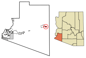
Location of Aztec in Yuma County, Arizona.
|
|
| Country | United States |
| State | Arizona |
| County | Yuma |
| Area | |
| • Total | 6.37 sq mi (16.50 km2) |
| • Land | 6.37 sq mi (16.50 km2) |
| • Water | 0.00 sq mi (0.00 km2) |
| Elevation | 509 ft (155 m) |
| Population
(2020)
|
|
| • Total | 2 |
| • Density | 0.31/sq mi (0.12/km2) |
| Time zone | UTC-7 (Mountain (MST)) |
| • Summer (DST) | UTC-7 (MST) |
| Area code(s) | 520 |
| FIPS code | 04-04930 |
| GNIS feature ID | 2582734 |
Aztec is a very small community located in Yuma County, Arizona, in the United States. It is called a "census-designated place" (CDP). This means it's an area that the U.S. Census Bureau identifies for collecting statistics.
In 2010, 47 people lived in Aztec. By 2020, the population was recorded as just 2 people. Aztec is about 509 feet (155 meters) above sea level. You can find it along Interstate 8, west of Tenmile Wash.
Population History
Aztec has been counted in the U.S. Census for many years. It first appeared in the 1920 census as the Aztec Precinct of Yuma County. At that time, 62 people lived there.
In 1930, the population grew to 296 people. The census noted that most of the residents were of Spanish or Hispanic background. By 1940, the population had decreased to 31.
The population went up again to 65 people in the 1960 census. In 2010, Aztec was officially named a census-designated place (CDP). The most recent census in 2020 showed only 2 residents.
See also
 In Spanish: Aztec (Arizona) para niños


