Bécancour Lake facts for kids
Quick facts for kids Bécancour Lake |
|
|---|---|

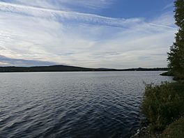
Lake Bécancour seen from the south shore to the north
|
|
| Coordinates | 46°04′17″N 71°14′31″W / 46.07133°N 71.24184°W |
| Primary outflows | Bécancour River |
| Basin countries | Canada, Quebec |
| Surface area | 0.973 kilometres (0.60 mi) |
| Average depth | 3.4 metres (11 ft) |
| Surface elevation | 402 metres (1,319 ft) |
Lake Bécancour is a beautiful lake found in Thetford Mines, a town in the Chaudière-Appalaches region of Quebec, Canada. This lake is super important because it's where the Bécancour River begins. The river then flows through the Centre-du-Québec area before joining the mighty St. Lawrence River.
Discover Lake Bécancour's Size
Lake Bécancour isn't huge, but it's a significant part of the local environment. Its total area is about 0.973 kilometres (0.60 mi). That's almost one square kilometer! The lake sits at an elevation of 402 metres (1,319 ft) above sea level. Its deepest point goes down about 3.4 meters (11 ft).
What's in a Name? The Story of Bécancour
Have you ever wondered how places get their names? The study of place names is called toponymy. The name "Lac Bécancour" was officially recognized on December 5, 1968. This happened thanks to the Commission de toponymie du Québec, which is a group in Quebec that makes sure all place names are correct and official.
 | Toni Morrison |
 | Barack Obama |
 | Martin Luther King Jr. |
 | Ralph Bunche |


