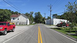
Bantam, Ohio facts for kids
Quick facts for kids
Bantam, Ohio
|
|
|---|---|

Bantam Road
|
|
| Country | United States |
| State | Ohio |
| County | Clermont |
| Township | Tate |
| Elevation | 863 ft (263 m) |
| Time zone | UTC-5 (Eastern (EST)) |
| • Summer (DST) | UTC-4 (EDT) |
| Area code(s) | 513 |
| GNIS feature ID | 1048485 |
Bantam is a small place in Ohio, United States. It's called an unincorporated community. This means it's a group of homes and businesses that don't have their own local government, like a city or town. Instead, it's part of a larger area called Tate Township in Clermont County.
One important building in Bantam is the Bethel Methodist Church. This church is very old and special. It is even listed on the National Register of Historic Places. This means it's recognized as an important historical site in the country.
Where is Bantam Located?
Bantam is found in the northwestern part of Tate Township. You can find it along Old State Route 125, which is also known as Bantam Road. South Bantam Road is another important road here.
The community is about 4.2 miles (about 6.7 kilometers) northwest of a town called Bethel. This helps you get an idea of where Bantam is on a map.
Bantam's Connection to a State Park
A big part of the land around Bantam was bought by the government many years ago. This land was used to create the East Fork State Park. This park has a large reservoir, which is like a big lake. The reservoir helps prevent floods, especially for the county seat, Batavia.
Today, East Fork State Park is a popular place for fun activities. You can go fishing, boating, hiking, and camping there. To enter the state park from Bantam, you can travel north onto Elklick Road.
Bantam's Post Office History
Bantam once had its own post office. It was first opened in the year 1837. This means people in Bantam could send and receive mail right in their community.
However, the Bantam post office eventually closed down. Today, most people who live in Bantam get their mail service from the post office in nearby Bethel.
 | Percy Lavon Julian |
 | Katherine Johnson |
 | George Washington Carver |
 | Annie Easley |


