
Barbosa, Antioquia facts for kids
Quick facts for kids
Barbosa, Antioquia
|
|||
|---|---|---|---|
|
Municipality and town
|
|||
 |
|||
|
|||

Location of the municipality and town of Barbosa, Antioquia in the Antioquia Department of Colombia
|
|||

Barbosa, Antioquia
Location in Colombia
|
|||
| Country | |||
| Department | |||
| Area | |||
| • Municipality and town | 205.7 km2 (79.4 sq mi) | ||
| • Urban | 2.79 km2 (1.08 sq mi) | ||
| Population
(2020 est.)
|
|||
| • Municipality and town | 54,347 | ||
| • Density | 264.21/km2 (684.29/sq mi) | ||
| • Urban | 23,921 | ||
| • Urban density | 8,574/km2 (22,210/sq mi) | ||
| Time zone | UTC-5 (Colombia Standard Time) | ||
| Climate | Af | ||
.svg)
.svg)
Barbosa is a cool town and a special kind of area called a municipality in the Antioquia Department of Colombia. It's about 39 kilometers (24 miles) away from the big city of Medellín. Barbosa is part of a larger group of towns called the Metropolitan Area of the Aburrá Valley.
In 2020, about 54,347 people lived there. People often call Barbosa the "Gateway to the Northeast" because it's known for its beautiful lakes and streams. It's also famous for its fun festivals, like the traditional Pineapple Festival in December and a Train Festival in August in the El Hatillo area.
Climate in Barbosa
Barbosa has a tropical rainforest climate, which means it's warm and rainy all year round. The weather doesn't change much between seasons. This type of climate is perfect for the lush green plants and forests you'll find there.
The average temperature is around 22 degrees Celsius (72 degrees Fahrenheit). It rains quite a lot, especially from April to October. Even so, there are still plenty of sunny days to enjoy the outdoors.
| Climate data for Barbosa (Progreso El Hda), elevation 1,500 m (4,900 ft), (1981–2010) | |||||||||||||
|---|---|---|---|---|---|---|---|---|---|---|---|---|---|
| Month | Jan | Feb | Mar | Apr | May | Jun | Jul | Aug | Sep | Oct | Nov | Dec | Year |
| Mean daily maximum °C (°F) | 28.1 (82.6) |
28.5 (83.3) |
28.8 (83.8) |
27.8 (82.0) |
28.1 (82.6) |
28.3 (82.9) |
28.3 (82.9) |
28.5 (83.3) |
28.1 (82.6) |
27.2 (81.0) |
27.1 (80.8) |
27.4 (81.3) |
28 (82) |
| Daily mean °C (°F) | 21.9 (71.4) |
22.2 (72.0) |
22.3 (72.1) |
22.1 (71.8) |
22.1 (71.8) |
22.2 (72.0) |
22.1 (71.8) |
22.2 (72.0) |
22.0 (71.6) |
21.7 (71.1) |
21.7 (71.1) |
21.7 (71.1) |
22 (72) |
| Mean daily minimum °C (°F) | 16.1 (61.0) |
16.1 (61.0) |
16.4 (61.5) |
16.9 (62.4) |
17.0 (62.6) |
16.5 (61.7) |
16.0 (60.8) |
16.2 (61.2) |
16.3 (61.3) |
16.5 (61.7) |
16.7 (62.1) |
16.6 (61.9) |
16.4 (61.5) |
| Average precipitation mm (inches) | 57.5 (2.26) |
80.1 (3.15) |
113.2 (4.46) |
188.6 (7.43) |
246.8 (9.72) |
199.1 (7.84) |
207.6 (8.17) |
202.3 (7.96) |
234.2 (9.22) |
235.4 (9.27) |
155.0 (6.10) |
83.3 (3.28) |
2,003 (78.9) |
| Average precipitation days (≥ 1.0 mm) | 8 | 10 | 13 | 20 | 21 | 18 | 19 | 18 | 20 | 22 | 18 | 11 | 193 |
| Average relative humidity (%) | 82 | 81 | 81 | 83 | 84 | 82 | 81 | 81 | 82 | 83 | 83 | 83 | 82 |
| Source: Instituto de Hidrologia Meteorologia y Estudios Ambientales | |||||||||||||
Images for kids
-
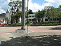
The main park in Barbosa, a great place to relax.
See also
 In Spanish: Barbosa (Antioquia) para niños
