
Barrhill, New Zealand facts for kids
Quick facts for kids
Barrhill
|
|
|---|---|
|
Village
|
|

View along Sycamore Avenue in Barrhill
|
|

Barrhill
Location in New Zealand
|
|
| Country | New Zealand |
| Region | Canterbury |
| Territorial authority | Ashburton District |
| Founded | 1876 |
| Founded by | Cathcart Wason |
| Named for | Barrhill, South Ayrshire |
| Area | |
| • Total | 36 km2 (14 sq mi) |
| • Land | 31 km2 (12 sq mi) |
| • Water | 5 km2 (2 sq mi) |
| Elevation | 210 m (690 ft) |
| Population
(2013 census) meshblock 2750400
|
|
| • Total | 66 |
| • Density | 1.83/km2 (4.75/sq mi) |
| Local iwi | Ngāi Tahu |
Barrhill is a small, quiet place in the Canterbury region of New Zealand. It's located on the South Island, near the Rakaia River. A man named Cathcart Wason started Barrhill in the 1870s. He named it after his old home in Scotland.
Wason wanted Barrhill to be a special "model village" for the people working on his large sheep farm. The village grew for a while, but then its population started to shrink. This happened because the railway line, which Wason hoped would pass through Barrhill, was built far away.
Some of the first buildings in Barrhill were made of concrete. These buildings, including a church and a gatehouse, are still standing today. The gatehouse is now a museum you can visit. Even though there aren't many buildings left, the village still looks charming with its planned streets and tree-lined avenues.
Contents
Geography

Barrhill is a small settlement located about 210 meters above sea level. It sits between a main road and the Rakaia River. The village is about 17 kilometers from Rakaia town and 21 kilometers from Methven.
The main part of Barrhill has a unique layout. Its outer streets form a shape like a trapezoid. Inside, two roads cross each other, dividing the area into four sections. Where these roads meet, there used to be a market square.
Barrhill is known for its beautiful tree-lined avenues. There are five of these avenues, each planted with a different type of tree: oak, poplar, birch, lime, and sycamore. These trees make the village look very pretty. An interesting fact is that when people saw an aerial photo in 1975, they noticed that the trees around the market square form a pattern that looks like the three circles of the Trinity.
History

Cathcart Wason moved to New Zealand from Scotland in 1868. He bought a large sheep farm in Canterbury and named it Corwar. This name also came from his father's land in Scotland. Wason wanted to create a special village on his land.
He planted many trees, like pines, oaks, and walnuts, to protect his farm from strong winds. This helped him raise sheep and grow wheat. He also used water power for his farm machines. By 1882, Corwar was a big farm with a large house and a gatehouse.
Founding the Model Village
Wason built Barrhill as a "model village" on his estate. A model village is a planned community designed to be a good place for workers to live. Barrhill had 28 sections, including a post office, a bakery, a school, a church, and 15 cottages. Wason named the village after his old home in Scotland. The post office opened in 1876, and the church started being built in the same year. These events marked the beginning of Barrhill.
Why Barrhill Declined
Wason had hoped that the Methven Branch railway line would pass close to Barrhill. However, the railway was built on a different route, many miles away. This was a big problem for Barrhill, and the village began to decline.
Without the railway, fewer people moved to Barrhill. The population started to drop. The school eventually closed in 1938 because there weren't enough children. Most of the original buildings were made of wood, but three important concrete buildings still stand today: the church, the school, and the schoolhouse.
Wason sold his property in 1900 because his dream for Barrhill didn't come true without the railway. The Barrhill post office closed in 1925.
In 2012, Heritage New Zealand (an organization that protects historic places) put up an information panel in Barrhill's market square. This panel shares the history of the village with visitors.
Population Changes
Barrhill grew and was at its busiest around 1885, when about 50 people lived in the village itself. But then, two things caused the population to go down. First, there was an economic downturn across New Zealand. People moved to find work, often near the new railway stations. Second, Wason started selling off parts of his land.
Today, Barrhill is part of a larger rural area called a meshblock. This area covers about 36 square kilometers, including some of the river. In 2013, the population of this meshblock was 66 people.
Notable Places
Three original buildings from Barrhill's early days are still standing. There's also a historic gatehouse located a bit outside the village. These buildings have lasted so long partly because they were built with very strong concrete, with some walls being 30 centimeters thick. The materials for these buildings were brought in by boat and then by horse-drawn carts.
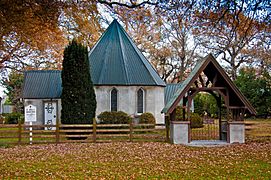
St John's Church
St John's Church was mostly paid for by Cathcart Wason. Construction started in 1876, and the first church service was held in July 1877. A special entrance gate, called a lych gate, was added later.
Today, St John's Church is part of the Anglican Church. Services are held there once a month. The church is recognized as a historic building by Heritage New Zealand.
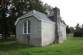
Former School and Teacher's House
The land for the school was bought early on, and a school building and a teacher's house were built in the market square. Both of these buildings were also made of concrete and are still here today.
The school was designed in a unique way, with windows only on the south side. This was meant to keep children from being distracted, but it meant the windows didn't get much sun. The school closed in 1938. Since then, it has been used as a community hall for events. The old teacher's house is now used as a holiday home. Both buildings are owned by the local council.
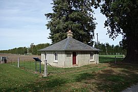
Corwar Gatehouse
The gatehouse is another original concrete building. It's located a short distance from the village on the main road. This gatehouse was the entrance to Wason's large farm, Corwar. His big house, which overlooked the Rakaia River, burned down after he left.
The gatehouse was left empty and fell into disrepair for a while. But in the 1970s, it was renovated by people whose families used to live there. It was officially reopened in 1979. The gatehouse is now a museum. You can arrange to visit it through the information centers in Ashburton or Methven.
Barrhill Cemetery
The Barrhill Cemetery is located a short walk southwest of the village. It's one of the cemeteries in the Ashburton District that is still open. The oldest burial recorded here was in 1881.
-
St John's Church
-
Former school; now community hall
-
Former teacher's house
-
Corwar Gatekeepers Lodge
-
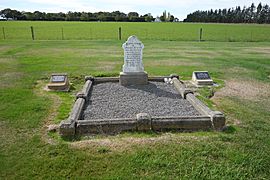
Barrhill Cemetery, with the trees of the village in the background


Notable People
Barrhill's founder, Cathcart Wason, was a very interesting person. He was a member of parliament in two different countries: first in New Zealand, and then later in the United Kingdom.
The New Zealand actress Tania Nolan grew up near Barrhill. She lived in the village for two years when she was a child.
