Bayamón, Cidra, Puerto Rico facts for kids
Quick facts for kids
Bayamón
|
|
|---|---|
|
Barrio
|
|

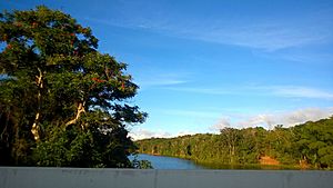
Lago de Cidra in Bayamón
|
|

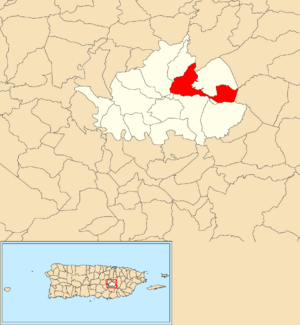
Location of Bayamón within the municipality of Cidra shown in red
|
|
| Commonwealth | |
| Municipality | Cidra |
| Area | |
| • Total | 3.15 sq mi (8.2 km2) |
| • Land | 2.85 sq mi (7.4 km2) |
| • Water | 0.30 sq mi (0.8 km2) |
| Elevation | 1,388 ft (423 m) |
| Population
(2010)
|
|
| • Total | 5,995 |
| • Density | 2,103.5/sq mi (812.2/km2) |
| Source: 2010 Census | |
| Time zone | UTC−4 (AST) |
Bayamón is a special kind of neighborhood, called a barrio, located in the town of Cidra, Puerto Rico. In 2010, about 6,000 people lived there.
A Look Back in Time
After the Spanish–American War, Puerto Rico became a territory of the United States. This happened because of a peace agreement called the Treaty of Paris of 1898. In 1899, the U.S. government counted the people living in Puerto Rico. They found that Bayamón and a nearby area called Monte Llano had about 1,222 residents together.
Here's how the population of Bayamón has changed over the years:
| Historical population | |||
|---|---|---|---|
| Census | Pop. | %± | |
| 1980 | 6,463 | — | |
| 1990 | 7,247 | 12.1% | |
| 2000 | 10,730 | 48.1% | |
| 2010 | 5,995 | −44.1% | |
| U.S. Decennial Census 1899 (shown as 1900) 1910-1930 1930-1950 1980-2000 2010 |
|||
Neighborhood Sections
Think of a barrio like Bayamón as a larger neighborhood. These larger neighborhoods are then divided into even smaller parts called sectores (say: sek-TOR-es). These sectores are like mini-neighborhoods within the barrio.
There are different kinds of sectores. Some are just called sector, while others might be called urbanización (a planned community), reparto (a housing development), or residencial (a residential area).
Here are some of the sectores you can find in Bayamón barrio:
- Brisas del Campo
- Calle Kennedy (North)
- Houses East of Highway 173
- Cidra Elderly Apartments
- Primitiva Vázquez Community
- Golden Living Cidra Condominium
- Las Mercedes
- Monte Verde (The Stone House)
- Juan Del Valle Plots
- Paseo Figueroa
- Maritza Development
- Aguedo Pagán Sector
- Basilio Meléndez Sector
- Brisas Del Lago Sector
- Camino Real Sector
- Cano Rolón Sector
- Certenejas I and II Sector
- Cintrón Sector (Rotary Club)
- Cortés Sector
- Daniel Pagán Sector
- Delgado Sector
- El Puente Sector
- Fito Medina Sector
- González Sector
- Jesús Morales Sector
- La Cuatro Sector
- La Glorieta Sector
- La Inmaculada Sector
- La Muralla (Dam) Sector
- Los Cotto Sector
- Los Pianos Sector
- Los Ramos Sector
- Machuquillo Sector
- Mira Monte Sector
- Monchito Santos Sector
- Navarro Sector
- Quebradillas Sector
- Ramos Sector
- Rivera Sector
- Exit to Caguas Treasure Valley Sector
- Tabo Merced Sector
- Trinidad Sector
- Vélez Sector
- Alturas del Arenal Urbanization
- Campo Primavera Urbanization
- Cidra Valley Urbanization
- Ciudad Primavera Urbanization
- El Lago Urbanization
- Estancias de Cidra Urbanization
- Estancias del Bosque Urbanization
- Hacienda La Cima Urbanization
- Haciendas de Treasure Island Urbanization
- Jardines de Treasure Island Urbanization
- Las Nereidas Urbanization
- Mónaco Urbanization
- Monte Primavera Urbanization
- Nogales Urbanization
- Palmeras Urbanization
- Treasure Island Urbanization
- Villa Encantada Urbanization
- Villa San Martín Urbanization
- Villas del Bosque Urbanization
- Vista Monte Urbanization
- Vistas de Sabana Urbanization
- Villa Rosa (Narices)
- Vistas de Sabanera
The Bayamón community and part of the Cidra urban area are also located within Bayamón barrio.
Learn More
 In Spanish: Bayamón (Cidra) para niños
- List of communities in Puerto Rico
- List of barrios and sectors of Cidra, Puerto Rico
 | Emma Amos |
 | Edward Mitchell Bannister |
 | Larry D. Alexander |
 | Ernie Barnes |


