Bendick Murrell facts for kids
Quick facts for kids Bendick MurrellNew South Wales |
|
|---|---|

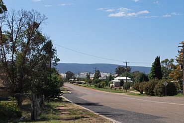
Main Street, Bendick Murrell
|
|
| Postcode(s) | 2803 |
| Location | |
| LGA(s) | Hilltops Council |
| State electorate(s) | Cootamundra |
| Federal Division(s) | Hume |
Bendick Murrell is a small town located in the South West Slopes region of New South Wales, Australia. It's about 354 kilometres (220 mi) west of Sydney, the state capital. The town is close to the Olympic Highway and is part of the Hilltops local government area.
Contents
Where is Bendick Murrell?
This town is found in the beautiful South West Slopes area of New South Wales. It sits right next to the Olympic Highway, which is a major road. The town is also on the Blayney–Demondrille railway line, which is a train track.
Population of the Town
According to the 2021 census, Bendick Murrell and the areas around it had a population of 143 people. A few years earlier, in 2016, there were 155 people living there.
What Does the Name Mean?
The name Bendick Murrell comes from the Aboriginal language. It means "plain," which describes a flat area of land. This name was first given to a large farm, known as a pastoral station, in the local area.
History and Services
Bendick Murrell has a history of providing important services to its community.
Early Schools
A small, temporary school was first set up in Bendick Murrell in 1883. The main school building that is still used today has been in the same spot since 1894. This shows how long education has been important here.
Post Office and Railway
A place to send and receive mail, called a receiving post office, opened in 1887. The Bendick Murrell railway station started operating in 1888. It was first called Marengo, but its name was changed to Bendick Murrell in 1889. The station was moved in 1915 to make more space for loading grain onto trains.
 | James Van Der Zee |
 | Alma Thomas |
 | Ellis Wilson |
 | Margaret Taylor-Burroughs |


