
Port Norris, New Jersey facts for kids
Quick facts for kids
Port Norris, New Jersey
|
|
|---|---|
_at_Hands_Landing_Road_and_Ogden_Avenue_in_Commercial_Township,_Cumberland_County,_New_Jersey.jpg)
Along Main Street near Ogden Avenue
|
|

Map Location of Port Norris in Cumberland County highlighted in red (left). Inset map: Location of Cumberland County in New Jersey highlighted in orange (right).
|
|
| Country | |
| State | |
| County | Cumberland |
| Township | Commercial |
| Area | |
| • Total | 6.92 sq mi (17.93 km2) |
| • Land | 6.38 sq mi (16.52 km2) |
| • Water | 0.55 sq mi (1.42 km2) 7.23% |
| Elevation | 10 ft (3 m) |
| Population
(2020)
|
|
| • Total | 1,111 |
| • Density | 174.19/sq mi (67.26/km2) |
| Time zone | UTC−05:00 (Eastern (EST)) |
| • Summer (DST) | UTC−04:00 (Eastern (EDT)) |
| ZIP Code |
08349
|
| Area code(s) | 856 |
| FIPS code | 34-60510 |
| GNIS feature ID | 02389697 |
Port Norris is a small community in New Jersey, United States. It is known as an unincorporated community and a census-designated place (CDP). A CDP is a special area that the government uses for counting people, but it's not a separate town with its own local government.
Port Norris is located within Commercial Township, in Cumberland County. For official statistics, it's considered part of the larger Vineland-Millville-Bridgeton area. In 2020, about 1,111 people lived there. Long ago, in 1911, people in Port Norris voted on whether to become a separate town, but they decided against it.
Contents
Geography of Port Norris
Port Norris covers a total area of about 17.93 square kilometers (6.92 square miles). Most of this area is land, about 16.52 square kilometers (6.38 square miles). The rest is water, which makes up about 7.23% of its total area.
This community is located close to where the Maurice River flows into the bay.
Population and People
| Historical population | |||
|---|---|---|---|
| Census | Pop. | %± | |
| 1990 | 1,701 | — | |
| 2000 | 1,507 | −11.4% | |
| 2010 | 1,377 | −8.6% | |
| 2020 | 1,111 | −19.3% | |
| Population sources: 2000 2010 2020 |
|||
Population in 2010
The 2010 United States census counted 1,377 people living in Port Norris. There were 481 households, which are groups of people living together, and 355 families. The population density was about 217 people per square mile (84 people per square kilometer). This means that, on average, 217 people lived in every square mile of land.
Most of the people in Port Norris were White (66.23%), and a good number were Black or African American (26.22%). A smaller number of people were Native American, Asian, or from other racial backgrounds. About 6.32% of the population identified as Hispanic or Latino.
In terms of households, about 29.5% had children under 18 years old. About 43.7% were married couples living together. About 23.3% were households led by a woman without a husband present.
The average household had about 2.80 people, and the average family had about 3.18 people.
Age Groups
The population of Port Norris in 2010 included people of all ages:
- 24.8% were under 18 years old.
- 9.8% were between 18 and 24 years old.
- 22.4% were between 25 and 44 years old.
- 28.8% were between 45 and 64 years old.
- 14.2% were 65 years old or older.
The average age of people in Port Norris was 37.5 years. For every 100 females, there were about 96.4 males.
Education
Students who live in Port Norris attend schools that are part of the Commercial Township School District.
Bivalve and Shell Pile: Oyster History

Near Port Norris, you'll find two small communities called Bivalve and Shell Pile. These places were once very important for the oyster industry. Their names even tell you about their history: "Bivalve" refers to shellfish like oysters, and "Shell Pile" points to the huge mounds of oyster shells that used to be there.
In the past, especially around 1939, Shell Pile was known for its large piles of oyster shells outside the packing sheds. It was a unique community where many African American workers lived in wooden buildings built on stilts over the marshy areas.
The oyster industry was at its busiest in 1955. However, by 1957, it faced a big problem. A disease caused by a tiny organism called Haplosporidium nelsoni (also known as MSX) killed about 90% of the oysters. This caused the industry to decline greatly. Today, Bivalve and Shell Pile are almost like ghost towns, with very few people living there.
Even though it was a busy oyster port, it wasn't a place for pleasure boats. As William Shellenberger wrote in his guide, Cruising the Chesapeake; a Gunkholer's Guide, you wouldn't find typical facilities for recreational boats there.
Images for kids
-
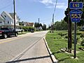
Along Main Street near Ogden Avenue
-
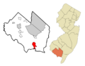
Map Location of Port Norris in Cumberland County highlighted in red (left). Inset map: Location of Cumberland County in New Jersey highlighted in orange (right).
-
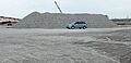
A massive pile of oyster shells in Shell Pile, New Jersey.
See also
 In Spanish: Port Norris para niños
