Booby Island (Queensland) facts for kids
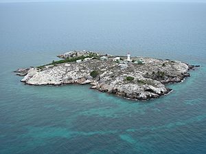
Booby Island is a small island in Australia. It is located about 45 kilometers (28 miles) northwest of Muttee Heads at the tip of Cape York Peninsula in Queensland. This island is found in the Torres Strait, a busy waterway. It is about 32 kilometers (20 miles) west of Thursday Island.
The Kaurareg people, who are the traditional owners of this area, call the island Ngiangu. European explorers, like Captain Cook, named it Booby Island. They did this because of the many booby birds that live there. Booby birds are a type of seabird.
Shipwrecks and Rescues
In the 1800s, many ships were lost or crashed near Booby Island. Because of this, supplies were stored on the island. These supplies helped sailors who survived shipwrecks.
Here are some of the ships that were lost:
- Delfshaven: This large sailing ship hit a hidden reef near Booby Island in 1862. The crew struggled to launch their boats in the big waves. After floating over the rocks, they tried to reach the Australian coast. But strong currents and local people made it hard. Some survivors eventually sailed towards Timor.
- Kanahooka: The iron steamship Kanahooka sank in a strong storm in 1894. It was south of Booby Island. The ship was carrying too much guano (bird droppings used as fertilizer). Big waves hit the ship, and it rolled over. The crew had only a short time to launch their boats and escape.
- Marina: The sailing ship Marina was lost in the Torres Strait in 1866. Its crew landed safely on Booby Island. Another ship later picked them up and took them to Singapore.
- Morning Star: This ship was completely wrecked in 1814 while sailing from Sydney to Batavia (now Jakarta). Some of the people who survived reached Booby Island. Another ship, the Eliza, rescued them in September.
Booby Island Lighthouse
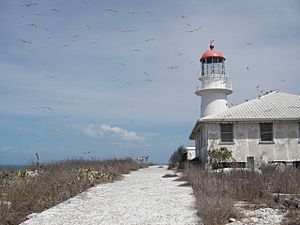
A lighthouse was built on Booby Island in 1890. It is 18 meters (59 feet) tall. The tower is made of timber and covered with iron. It is painted white with a red top where the light shines. The light flashes once every 7.5 seconds. This lighthouse helps guide ships safely through the Torres Strait.
Heritage Listing
Booby Island is important for its history. It has a special "heritage listing." This means that places like the Booby Island Light are protected. They are important parts of history and culture.
Rock Art and Graffiti
Booby Island has caves along its shoreline. These caves hold ancient Indigenous rock art. They also have graffiti left by sailors and others. The first time this was written about was in 1857. A British naval officer wrote about ship names in a cave called the 'Post Office Cave'.
The island was a common stop for ships. Sailors would stop for water and repairs. Many people left their marks on the cave walls. They wrote their names next to or even over the Indigenous art. Lighthouse keepers and their families also wrote about the painted caves. Some of their names can be seen there too.
In the 1980s and 1990s, a team from the Queensland Museum photographed the art and graffiti. Studies have shown marks left by:
- Indigenous visitors, including drawings of sea creatures.
- Ships passing by, some from as early as 1841.
- Individuals who were on these ships.
- Lighthouse keepers, their families, and visitors.
- Military people who lived on the island during World War II. They were part of a unit that watched for signals in the Pacific.
 | Chris Smalls |
 | Fred Hampton |
 | Ralph Abernathy |


