Botija, Cáceres facts for kids
Quick facts for kids
Botija
|
|||
|---|---|---|---|
|
municipality
|
|||
|
|||
 |
|||
| Country | Spain | ||
| Autonomous community | Extremadura | ||
| Province | Cáceres | ||
| Municipality | Botija | ||
| Area | |||
| • Total | 193 km2 (75 sq mi) | ||
| Elevation | 411 m (1,348 ft) | ||
| Population
(2018)
|
|||
| • Total | 187 | ||
| Time zone | UTC+1 (CET) | ||
| • Summer (DST) | UTC+2 (CEST) | ||
| Website | http://www.botija.es/ | ||
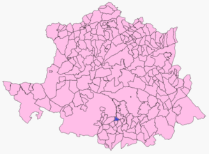
Botija is a small town, also known as a municipality, located in the province of Cáceres. This province is part of the Extremadura region in Spain.
As of 2018, Botija is home to about 187 people. It's a quiet place with a rich history, typical of many small Spanish towns.
Where is Botija?
Botija is found in the western part of Spain. It is part of the Extremadura region, which is known for its beautiful natural areas and historical sites. The town sits at an elevation of 411 meters (about 1,348 feet) above sea level.
Location Details
- Country: Spain
- Autonomous Community: Extremadura
- Province: Cáceres
Life in Botija
Life in Botija is generally peaceful. The town covers an area of 193 square kilometers (about 74.5 square miles). This means there's plenty of space around the town.
Time Zone
Botija follows Central European Time (CET), which is UTC+1. During summer, they switch to Central European Summer Time (CEST), which is UTC+2. This is common across much of Europe.
See also
- Botija (Cáceres) for kids (in Spanish)


