Bradford Common Historic District facts for kids
Quick facts for kids |
|
|
Bradford Common Historic District
|
|

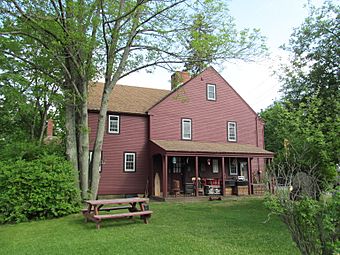
Kimball Tavern Antiques
|
|
| Location | Haverhill, Massachusetts |
|---|---|
| Area | 35 acres (14 ha) |
| Built | 1690 |
| Architectural style | Italianate, Gothic Revival |
| NRHP reference No. | 77000179 |
| Added to NRHP | September 14, 1977 |
The Bradford Common Historic District is a special area in Haverhill, Massachusetts. It used to be the main town center for Bradford. This was before Bradford became part of Haverhill in 1897. The district is centered around a common, which is like a town park. You can find it where South Main and Salem Streets meet.
This area was the heart of Bradford from about 1750. It was where people gathered for town events and where businesses were located. Today, you can still see many old buildings here. They show what life was like from the 1700s to the early 1900s. In 1977, this district was added to the National Register of Historic Places. This means it's recognized as an important historical site.
Contents
Exploring Bradford Common's Past
The town of Bradford was first settled in 1649. Its very first town center was a bit east of where the common is now. In 1749, the Kimball family gave this land to the town. This new spot became the town's central meeting place. It was also close to the ferry that connected Bradford to Haverhill.
Key Buildings and Landmarks
The oldest building in the district is a former tavern. It was owned by the Kimball family and built around 1690. Most of the buildings in the village are homes. However, there are also some important public buildings.
The White Church, built in 1848, stands out in the center. Other buildings that used to be important for the town have new uses. For example, the old town hall is now a public school.
A Campus with History
A large part of the district is a college campus. Today, it's home to Northpoint Bible College. This campus was originally for Bradford College. Bradford College was one of the first schools in the country. It was special because it allowed both boys and girls to study together.
What You'll See Today
The historic district is shaped like a triangle. It's formed by South Main Street, Salem Street, and Church Street. South Main and Salem Streets were important roads long ago. They connected Haverhill to big cities like Boston and Rowley.
The district stretches north along South Main Street to Carleton Avenue. It goes south past the college campus to Kingsbury Avenue. It also covers a shorter distance along Salem Street. Most of the buildings are wooden houses. They are usually one or two stories tall. You'll see many different styles of architecture. These styles were popular in the 1700s and 1800s.


