
Bras d'Or Lakes Scenic Drive facts for kids
Quick facts for kids Bras d'Or Lakes Scenic Drive |
|
|---|---|
| Lua error in Module:Infobox_road/map at line 15: attempt to index field 'wikibase' (a nil value). | |
| Route information | |
| Length | 417 km (259 mi) |
| Component highways |
|
| Major junctions | |
| Tourist loop around Bras d'Or Lake | |
| Location | |
| Counties: | Cape Breton Regional Municipality, Inverness, Victoria |
| Highway system | |
| Provincial highways in Nova Scotia | |
The Bras d'Or Lakes Scenic Drive is a super cool road trip route on Nova Scotia's beautiful Cape Breton Island. It winds all the way around the amazing Bras d'Or Lake, which is a huge saltwater lake that's almost like an inland sea! This drive is about 417 kilometers (259 miles) long, offering incredible views, charming towns, and fun places to explore. It's a great way to see the natural beauty and culture of Cape Breton.
Contents
Driving the Scenic Route
The Bras d'Or Lakes Scenic Drive isn't just one road; it's a collection of different routes that connect to form a big loop around the lake. You'll drive on a mix of larger highways and smaller, quieter roads.
Main Roads You'll Use
To follow the drive, you'll travel on parts of these main roads:
- Highway 105
- Trunk 4
- Route 205
- Route 216
- Route 223
Cool Places to See
As you drive around the Bras d'Or Lake, you'll pass through many interesting communities and areas. Each one has its own unique charm and things to discover.
Towns and Villages
Some of the places you might see along the way include:
- Baddeck
- Boularderie Island
- Little Bras d'Or
- Boisdale
- Big Beach
- Bras d'Or
- Christmas Island
- Grand Narrows
- Eskasoni
- East Bay
- Ben Eoin
- Irish Cove
- Chapel Island
- St. Peter's
- Dundee
- West Bay
- Marble Mountain
- Orangedale
- Whycocomagh
- Bucklaw
- Little Narrows
- Iona
- Washabuck
- Nyanza
Parks to Explore
There are also several provincial parks along the route where you can stop, stretch your legs, and enjoy nature. These are great spots for picnics or just taking in the views.
- Battery Provincial Park
- Ben Eoin Provincial Park
- Bras d'Or Lookoff and Picnic Park
- Dalem Lake Provincial Park
- Groves Point Provincial Park
- MacCormack Provincial Picnic Park
- Whycocomagh Provincial Park
Amazing Bridges
You'll cross some impressive bridges as you travel around the lake. These bridges connect different parts of the island and offer great views of the water.
- Barra Strait Bridge
- Crowdis Bridge
- Seal Island Bridge
Images for kids
-
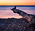
Sunset over Bras d'Or Lake in Irish Cove, Nova Scotia, in September 2015
.jpg)
