
Bras d'Or Lake facts for kids
Quick facts for kids Bras d'Or Lake |
|
|---|---|

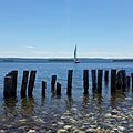
West Bay in early summer
|
|

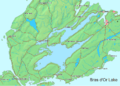
Bras d'Or Lake
Location in Nova Scotia
|
|
| Location | Cape Breton Island, Nova Scotia |
| Coordinates | 45°51′37″N 60°46′44″W / 45.86028°N 60.77889°W |
| Type | estuary |
| Primary outflows | Gulf of St. Lawrence Atlantic Ocean |
| Basin countries | Canada |
| Max. length | 100 kilometres (62 mi) |
| Max. width | 50 kilometres (31 mi) |
| Surface area | 1,099 km2 (424 sq mi) |
| Max. depth | 287 m (942 ft) |
| Water volume | 32,000,000,000 m3 (4.2×10¹⁰ cu yd) |
| Shore length1 | 1,000 kilometres (621 mi) (excluding islands) |
| Surface elevation | 0 metres (0 ft) (sea level) |
| 1 Shore length is not a well-defined measure. | |

The Bras d'Or Lake (pronounced "brah-DOR" or "brad-OR") is a large body of water in the middle of Cape Breton Island in Nova Scotia, Canada. It's often called an "inland sea" because it has both fresh and salt water. Even though people sometimes say "Bras d'Or Lakes," it's actually one big lake.
This special lake is connected to the Atlantic Ocean through natural channels. These include the Great Bras d'Or Channel and the Little Bras d'Or Channel. There's also the St. Peters Canal, a lock canal built in 1869, which connects the lake to the Atlantic at its southern tip.
The name "Bras d'Or" has a few possible meanings. Many believe it comes from the French words "Bras d'Or," meaning "arm of gold." This might refer to how the sun shines on its waters. However, older maps from 1872 and earlier show the lake named "Le Lac de Labrador." This means "The Lake of the Laborer." The Mi'kmaq people, who are the Indigenous people of the area, called it Pitu'pok. This means "long salt water."
Bras d'Or Lake is huge! It covers about 1,099 square kilometers (424 square miles). It's roughly 100 kilometers (62 miles) long and 50 kilometers (31 miles) wide. The deepest part is 287 meters (942 feet) deep in the St. Andrews Channel. The lake is surrounded by hills and small mountains. In 2011, UNESCO named this area the Bras d'Or Lake Biosphere Reserve. This means it's a special place where nature and people live together in a balanced way.
Contents
What are the parts of Bras d'Or Lake?
_Bridge_(cropped).jpg)
The shape of the land around the lake divides it into several main areas:
Northern Basin
- Great Bras d'Or
- Little Bras d'Or
- St. Andrews Channel
- St. Patricks Channel
- Baddeck Bay
- Nyanza Bay
- Whycocomagh Bay
Southern Basin
- Denys Basin
- St. Peters Inlet
- East Bay
- West Bay
The widest part of the lake is about 25 kilometers (16 miles) across in the southern basin. This area includes East Bay, West Bay, Denys Basin, and St. Peters Inlet. The Barra Strait connects the northern and southern parts of the lake. You can cross it using highway and railway bridges.
What rivers flow into the lake?
Many rivers flow into Bras d'Or Lake. Some of the main ones are:
- River Denys
- Middle River
- Baddeck River
- Skye River
- Georges River
- Washabuck River
The lake's water is a mix of fresh and salt water. It's called "brackish" water. This is because not much ocean water flows in and out, but a lot of fresh water comes from the rivers and streams. This makes the lake less salty than the ocean. Because it's a special natural area, people work to keep the lake's water clean and healthy.
How does the lake affect the weather?
The Bras d'Or Lake usually doesn't freeze much in winter. This is because of its large size and its salt content, which helps prevent ice from forming. When the lake stays ice-free, it can make the winters in nearby areas of Cape Breton warmer. This is similar to how large lakes in other parts of the world can affect local weather.
What kind of wildlife lives here?
Bras d'Or Lake is full of amazing wildlife! People fish for lobsters and oysters here. The lake's shorelines are mostly untouched, which is great for bald eagles. You can often see many of these majestic birds flying around.
Can you go boating on the lake?
The Bras d'Or Lake is a very popular place for boating in the summer. Many boaters enter the lake from the south through the St. Peters Canal. The St. Peter's Lion's Club Marina is often the first stop for boats. Baddeck also has marinas and boatyards. Other marinas can be found in Ben Eoin and Grand Narrows.

Sailboat racing has a long history on the Bras d'Or. Yacht clubs around the lake host yearly races and events. The Bras d'Or Yacht Club has held its Regatta Week for over 100 years! The East Bay Regatta is another popular event, with many boats participating.

"Race the Cape" was a long sailing race that covered 175 nautical miles. It went through the Bras d'Or Lake and along Cape Breton Island's Atlantic coast. This race was for both cruising boats and racing yachts. The last "Race the Cape" was in 2017.
The lake has many protected coves and harbors. This makes it a great place for sailing because the water stays calm. Large ships also use the lake to reach places like a gypsum quarry at Little Narrows. In the past, boats carried coal, gypsum, and other goods across the lake. Mail boats also used to run on the lake until the 1960s.
What is the Mi'kmaq connection to the lake?
The Mi'kmaq people called the Bras d'Or "Pitupaq," which means "long salt water." The lake was like a highway, connecting ancient communities around its shores and even to the ocean. Important Mi'kmaq communities like Chapel Island, Eskasoni, Wagmatcook, and Waycobah were linked by canoe. The lake was also a very important source of food for these communities, providing mussels, crabs, clams, fish, and more.
How was the lake a research center?
From 1886, the famous inventor Alexander Graham Bell made his home and research lab at Beinn Bhreagh (pronounced "ben vreeah"). This beautiful estate was on a peninsula across from Baddeck. Bell lived there for half of his life. Because of his connection, Beinn Bhreagh and Baddeck are often shown on National Geographic maps.
Bell set up his first Bell Labs research center at Beinn Bhreagh. He used the Bras d'Or Lake to test many of his inventions. These included kites that could carry people, early airplanes, and hydrofoil boats.
The first flight of the Silver Dart
Baddeck Bay, which is part of the Bras d'Or Lake, was the site of a very important event. In January 1909, the Silver Dart airplane made the first official powered flight in the British Empire (which included Canada at the time). This airplane was designed by Dr. Alexander Graham Bell and his team at Bell Labs. It flew off the frozen ice of Baddeck Bay. To celebrate 100 years later, a copy of the Silver Dart was flown off the ice in the same spot in January 2009.
Bell's lab also designed a hydrofoil boat called the HD4. In 1919, it set a water speed record of 71 miles per hour (63 knots). Later, a Canadian Navy experimental hydrofoil, the HMCS Bras d'Or, was named after Bell's hydrofoils. It was known as one of the fastest warships ever built.
In 2003, National Geographic Traveler magazine rated Cape Breton Island as one of the top places in the world for sustainable tourism. They said the Bras d'Or Lake played a big part in this honor.
The Bras d'Or was a tourist train named after the beautiful scenery of the lake.
Images for kids
-
Bras d'Or Lake
-
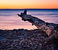
Sunset over Bras d'Or Lake in Irish Cove, Nova Scotia, in September 2015
-
Marble Mountain in early summer
-
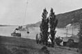
Passenger steamer on Bras d'Or Lake near New Campbellton, around 1903.

.jpg)

See also
 In Spanish: Lago Bras d'Or para niños
