East Bay (Nova Scotia) facts for kids
Quick facts for kids East Bay |
|
|---|---|

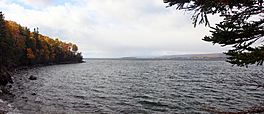
East Bay in October
|
|
| Location | Cape Breton Island, Nova Scotia |
| Coordinates | 45°53′52″N 60°37′17″W / 45.89778°N 60.62139°W |
| Type | Bay |
| Part of | Bras d'Or Lake |
| Ocean/sea sources | Gulf of Saint Lawrence, Atlantic ocean |
| Basin countries | Canada |
| Max. length | 22 nautical miles (41 km; 25 mi) |
| Max. width | 5.2 nautical miles (9.6 km; 6.0 mi) |
| Settlements | Cape Breton Regional Municipality
Communities include (from northwest to the bay's eastern terminus to southwest):
|
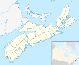
East Bay is a cool bay located on Cape Breton Island in Nova Scotia, Canada. It's part of the larger Bras d'Or Lake system. The entire bay is found within Cape Breton County.
Contents
What is East Bay Like?
East Bay is one of three long, narrow parts of the Bras d'Or Lake that stretch out to the east. The other two are St. Andrews Channel and Great Bras d'Or Channel. The Bras d'Or Lake is like a fjord (a long, narrow, deep inlet of the sea between high cliffs). It connects to the Atlantic Ocean through two small channels. Because of this connection, the water in East Bay is a mix of fresh and salt water, which is called "brackish."
East Bay opens up to the main part of Bras d'Or Lake in the southwest. It lies between the Boisdale Hills to the north and the East Bay Hills to the south. The bay is about 8.3 kilometres (5.2 mi) wide at its mouth, between Benacadie Point and Middle Cape. It stretches about 41 kilometres (25 mi) eastward to its end at Portage. The shoreline of East Bay is about 77.9 kilometres (48.4 mi) long.
The shores of the bay are usually covered in thick forests. They have rocky edges with many barrachois (barrier beaches) and sandbars. There are also some islands along the northern shore, which were formed by glaciers. A sandbar, called the East Bay Sandbar, stretches about 1.25 kilometres (0.78 mi) across the narrower eastern end of the bay.
The Name of the Bay
The name "East Bay" has been used in writing since at least 1829. It appeared on maps as early as 1855. However, an older name, "St. Andrews Channel," was also sometimes used on maps until about 1890. Today, "St. Andrews Channel" refers to the part of the lake just north of East Bay.
Water and Weather
East Bay doesn't have strong tides because its connections to the Atlantic Ocean are narrow and shallow. A lot of freshwater also flows into the bay. This means the water isn't very salty. In the summer, the water gets warmer, and layers of different temperatures and saltiness form.
In winter, the bay is usually covered with ice. The water temperature can warm up by more than 10 degrees Celsius from May to July. The water in East Bay moves like water in an estuary (where a river meets the sea). The less salty water near the surface flows towards the main lake, and deeper, saltier water flows into the bay. Strong winds can create big waves in the bay.
How the Bay Was Formed
The land around East Bay is often very steep, rising quickly from the water's edge to heights of 180 to 200 metres (590 to 660 ft). Like other large channels in the Bras d'Or Lake, East Bay runs from northeast to southwest. This direction was formed about 360 million years ago by tectonic plate movements and cracks in the Earth's crust. These movements created small basins (low areas) between strong, rocky highlands.
The northern shore of the bay is mostly made of sedimentary rocks like shale, sandstone, and gypsum. The southern shore is formed by older rocks, some of the oldest around the Bras d'Or Lake. These include volcanic rocks and granite.
East Bay sits in a low area that formed in softer rocks before the Quaternary ice ages. The deep channel of East Bay, which is 81–82 metres (266–269 ft) deep, was likely carved out by glaciers over hundreds of thousands of years. The cliffs along the lake are special because they contain old plant materials from before the last ice age, which tell us about past environments.
The bottom of the lake was shaped by glacial deposits (like moraines) and silty muds left behind when the ice melted.
Plants and Animals
The plants in East Bay, especially seaweeds, are similar to those found in the Gulf of Saint Lawrence. Because of the winter ice, some seaweeds that usually grow in shallow areas are found in deeper water here. Sheltered parts of the bay have plants that can grow in both salty and fresh marsh areas.
East Bay is home to the American Oyster, which likes the warmer water temperatures here. You can also find many sand shrimp, which are usually found further south. Other creatures living in the bay include lobsters, Atlantic rock crabs, and the Green crab (which is an invasive species). You might also see sea urchins, starfish, sand dollars, and periwinkles.
Many different fish live in East Bay, such as blueback herring, blackspotted stickleback, American eel, and a southern group of Greenland cod. There are also rainbow trout in the bay. These fish provide food for birds like the great blue heron, double-crested cormorant, and bald eagle.
Fun Things to Do
The East Bay area is very important to the Mi'kmaq people, who have lived here for a long time. Eskasoni, a Mi'kmaq reserve, is the largest community on the northern shore of the bay.
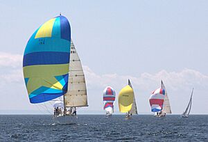
East Bay is a popular spot for boating. Sailboat racing has a long history here. The East Bay Regatta is a fun event held every year on the last weekend of July since 1984. It includes races and other social activities. Sometimes, as many as 40 boats take part! A new marina for boats was built in 2013 in the community of Ben Eoin. It's part of a larger complex that includes a ski hill and a golf course.
There are also great places to swim. You can find a popular public swimming beach at the East Bay Sandbar, near the small community of East Bay. Another beach is in the community of Big Pond.
Communities Around the Bay
Many communities are located along the shoreline of East Bay. Starting from the northwest and going towards the eastern end, then southwest, they include:
- Benacadie
- Castle Bay
- Eskasoni
- Island View
- Northside East Bay
- Portage (at the very end of the bay)
- East Bay
- Ben Eoin
- St. Andrew's Channel
- Big Pond
- Big Pond Centre
- Middle Cape
- Irishvale
 | William L. Dawson |
 | W. E. B. Du Bois |
 | Harry Belafonte |


