
Cape Breton Regional Municipality facts for kids
Quick facts for kids
Cape Breton Regional Municipality
|
|||
|---|---|---|---|

From top, left to right: Highland Arts Theatre, Gabarus Light House, gate at Fortress of Louisbourg, Big Fiddle, Sydney waterfront
|
|||
|
|||
| Nickname(s):
A Community of Communities
|
|||
| Motto(s):
Fortuna Non Mutat Genus
(Circumstances Do Not Change Our Origin) |
|||

Location of Cape Breton Regional Municipality
|
|||
| Country | Canada | ||
| Province | Nova Scotia | ||
| County | Cape Breton | ||
| First Nations | Eskasoni First Nation, Membertou First Nation | ||
| Established | August 1, 1995 | ||
| Electoral Districts Federal |
Cape Breton—Canso / Sydney—Victoria |
||
| Provincial | Cape Breton Centre / Cape Breton-Richmond / Glace Bay / Northside-Westmount / Sydney River-Mira-Louisbourg / Sydney-Whitney Pier / Victoria-The Lakes | ||
| Government | |||
| • Type | Cape Breton Regional Council | ||
| Area
(2016)
|
|||
| • Land | 2,430.06 km2 (938.25 sq mi) | ||
| • Urban | 29.43 km2 (11.36 sq mi) | ||
| Elevation | Sea Level to 235 m (0 to 771 ft) | ||
| Population
(2021)
|
|||
| • Municipality | 93,694 | ||
| • Density | 38.7/km2 (100/sq mi) | ||
| • Change 2016–21 | |||
| • Census ranking (2016) | 58 of 5,162 | ||
| Demonym(s) | Cape Bretoner | ||
| Time zone | UTC−4 (AST) | ||
| • Summer (DST) | UTC−3 (ADT) | ||
| Postal code |
B1x, B2x
|
||
| Area code(s) | 902 | ||
| Dwellings | 45,342 | ||
| Median household income (2020) | C$ 62,400 | ||
| Coastline | Atlantic 800 km (500 mi) Bras d'Or Lakes 400 km (250 mi) |
||
| Roadways | 1,600 km (1,000 mi) | ||
| NTS Map | 11K1 Sydney | ||
| GNBC Code | CBUCD | ||
| Website | cbrm.ns.ca | ||


The Cape Breton Regional Municipality (often called CBRM) is a large area in Nova Scotia, Canada. It's the second biggest municipality in the province and is like the main hub of Cape Breton Island. In 2021, about 93,694 people lived here. CBRM was formed in 1995 when eight smaller towns and areas in Cape Breton County joined together.
This region is home to many important places. These include the Canadian Coast Guard College, Cape Breton University, and the NSCC Marconi campus. You'll also find cultural spots like the historic Savoy Theatre and the Highland Arts Theatre. The Celtic Colours International Festival is a popular event held here.
CBRM is also a big tourist spot. The Fortress of Louisbourg is a national park where you can see a huge historical reconstruction. It's the largest one in North America! Many cruise ships visit the Port of Sydney, bringing lots of visitors. The Trans-Canada Highway ends in North Sydney, where ferries connect to Newfoundland and Labrador.
Contents
Exploring Cape Breton's Past
Who Lived Here First?
Long, long ago, about 13,500 years ago, the ice from the last ice age started to melt away from this area. By 11,000 years ago, the land was mostly clear of ice. The first people to live here were called Paleo-Indians. They followed large animals like caribou as the ice disappeared. Over thousands of years, their way of life led to the culture and language of the Mi'kmaq people.
The Mi'kmaq People

Before Europeans arrived, the Mi'kmaq people lived a nomadic lifestyle. This means they moved around with the seasons to find food and resources. Cape Breton Island is part of their traditional territory, called Mi'kma'ki. This large area included what is now Nova Scotia, parts of Maine, Newfoundland, and the Gaspé Peninsula.
French Settlers Arrive
The French were the first Europeans to claim this region, calling it Acadia. For many years, control of the land went back and forth between the French and the English. In 1713, a treaty gave France control of "Île Royale" (which is now Cape Breton Island). In 1719, the French started building a strong, fortified town called Louisbourg.
The Fortress of Louisbourg was captured by British forces, then given back to France. It was captured again during the Seven Years' War. After this, the people living there were forced to leave, and the fortress was completely destroyed by the British in 1760.
After the French Era
After the Seven Years' War, in 1763, Île Royale was renamed Cape Breton Island. It officially became part of Nova Scotia. For a while, it was part of Halifax County. Then, in 1784, the island became its own separate colony with Sydney as its capital. However, by 1820, it rejoined Nova Scotia.
The Industrial Age: Coal and Steel

Coal mining started in the 1700s to supply the Fortress Louisbourg. Big industrial mining began in 1826. Later, the Dominion Coal Company (DOMCO) took over many mines in 1893. Coal production was highest in the early 1940s. By 1965, the company decided to stop coal mining.
To help the area, the Canadian government created the Cape Breton Development Corporation (DEVCO) in 1967. DEVCO was meant to run the mines for a while and then slowly help the economy move away from relying on coal. At the same time, the provincial government took over the steel mill in Sydney, creating the Sydney Steel Corporation (SYSCO). Over time, the coal mines closed, with the last one shutting down in 2001. SYSCO was also eventually sold.
DEVCO stopped operating in 2009. Its remaining work was given to Enterprise Cape Breton Corporation (ECBC), which aimed to help CBRM's economy grow in new ways.
How CBRM Was Formed

In 1992, a report suggested that Nova Scotia had too many small municipalities (67 of them!). This made it hard to provide services efficiently. So, the provincial government decided to combine some areas.
The Cape Breton Regional Municipality Act was put into action, and CBRM was officially created on August 1, 1995. This brought together the Municipality of the County of Cape Breton and the towns of Sydney, Glace Bay, Sydney Mines, New Waterford, North Sydney, Dominion, and Louisbourg.
CBRM's Economy Today

After the coal and steel industries closed, Cape Breton faced challenges. However, its economy is now expected to grow steadily. The region is strong in fishing and forestry. It also has many jobs in services like trade, transportation, education, and health care.
Tourism is a big part of CBRM's economy. Places like the Cape Breton Highlands, Bras d'Or Lake, and the Fortress of Louisbourg attract many visitors. Sydney also has a growing food scene and welcomes many cruise ships. A new cruise ship dock is even being built!
The old Sydney Steel Corporation site has been turned into the Harbourside Commercial Park. This area is now used for offices and light industries.
Geography and Climate

The Cape Breton Regional Municipality covers almost all of Cape Breton County. Only the Eskasoni and Membertou First Nations are separate.
What's the Weather Like?
CBRM has a cool and wet climate, but it's generally warmer than most other places in Canada. The average yearly temperature is about 6 degrees Celsius. In summer, the average high is around 25 degrees Celsius, and it rarely gets hotter than 30 degrees Celsius. In winter, the average low is about -10 degrees Celsius. Temperatures rarely drop below -20 degrees Celsius, but strong winds can make it feel much colder.
| Climate data for Cape Breton Regional Municipality (JA Douglas McCurdy Sydney Airport) WMO ID: 71707; coordinates 46°10′00″N 60°02′53″W / 46.16667°N 60.04806°W; elevation: 61.9 m (203 ft); 1981–2010 normals, extremes 1870–present and from April 1941 to the present day at Sydney Airport. |
|||||||||||||
|---|---|---|---|---|---|---|---|---|---|---|---|---|---|
| Month | Jan | Feb | Mar | Apr | May | Jun | Jul | Aug | Sep | Oct | Nov | Dec | Year |
| Record high humidex | 18.2 | 19.0 | 25.0 | 26.0 | 36.8 | 43.4 | 41.8 | 41.9 | 38.9 | 30.4 | 25.5 | 18.5 | 43.4 |
| Record high °C (°F) | 16.9 (62.4) |
18.0 (64.4) |
24.0 (75.2) |
27.2 (81.0) |
31.1 (88.0) |
34.4 (93.9) |
33.9 (93.0) |
36.7 (98.1) |
32.3 (90.1) |
27.2 (81.0) |
22.2 (72.0) |
16.7 (62.1) |
36.7 (98.1) |
| Mean daily maximum °C (°F) | −1.1 (30.0) |
−1.5 (29.3) |
1.5 (34.7) |
6.6 (43.9) |
13.1 (55.6) |
18.6 (65.5) |
23.1 (73.6) |
22.9 (73.2) |
18.8 (65.8) |
12.6 (54.7) |
7.3 (45.1) |
2.1 (35.8) |
10.3 (50.5) |
| Daily mean °C (°F) | −5.4 (22.3) |
−5.9 (21.4) |
−2.6 (27.3) |
2.5 (36.5) |
7.9 (46.2) |
13.2 (55.8) |
17.9 (64.2) |
18.0 (64.4) |
14.0 (57.2) |
8.5 (47.3) |
3.8 (38.8) |
−1.5 (29.3) |
5.9 (42.6) |
| Mean daily minimum °C (°F) | −9.6 (14.7) |
−10.3 (13.5) |
−6.7 (19.9) |
−1.6 (29.1) |
2.7 (36.9) |
7.7 (45.9) |
12.6 (54.7) |
13.1 (55.6) |
9.1 (48.4) |
4.3 (39.7) |
0.2 (32.4) |
−5 (23) |
1.4 (34.5) |
| Record low °C (°F) | −31.7 (−25.1) |
−31.7 (−25.1) |
−31.1 (−24.0) |
−17.8 (0.0) |
−7.8 (18.0) |
−3.9 (25.0) |
0.6 (33.1) |
2.2 (36.0) |
−2.2 (28.0) |
−5.6 (21.9) |
−13.9 (7.0) |
−23.3 (−9.9) |
−31.7 (−25.1) |
| Record low wind chill | −42.6 | −41.1 | −34.3 | −21.4 | −11.3 | −6.1 | 0.0 | 0.0 | −5.1 | −10.5 | −19.3 | −31.3 | −42.6 |
| Average precipitation mm (inches) | 152.5 (6.00) |
128.1 (5.04) |
130.0 (5.12) |
133.3 (5.25) |
103.2 (4.06) |
96.9 (3.81) |
88.5 (3.48) |
100.2 (3.94) |
118.7 (4.67) |
142.9 (5.63) |
156.0 (6.14) |
167.0 (6.57) |
1,517.2 (59.73) |
| Average rainfall mm (inches) | 80.5 (3.17) |
63.8 (2.51) |
83.2 (3.28) |
112.2 (4.42) |
100.9 (3.97) |
96.9 (3.81) |
88.5 (3.48) |
100.2 (3.94) |
118.7 (4.67) |
142.2 (5.60) |
144.0 (5.67) |
111.2 (4.38) |
1,242.4 (48.91) |
| Average snowfall cm (inches) | 74.3 (29.3) |
65.3 (25.7) |
48.1 (18.9) |
21.4 (8.4) |
2.3 (0.9) |
0.0 (0.0) |
0.0 (0.0) |
0.0 (0.0) |
0.0 (0.0) |
0.62 (0.24) |
12.4 (4.9) |
58.5 (23.0) |
283.0 (111.4) |
| Average precipitation days (≥ 0.2 mm) | 20.6 | 16.5 | 16.6 | 15.8 | 14.5 | 14.0 | 11.7 | 12.7 | 13.5 | 15.9 | 18.1 | 21.0 | 191.0 |
| Average rainy days (≥ 0.2 mm) | 8.4 | 7.3 | 9.5 | 13.0 | 14.1 | 14.0 | 11.7 | 12.7 | 13.5 | 15.8 | 15.4 | 11.5 | 146.9 |
| Average snowy days (≥ 0.2 cm) | 16.6 | 12.6 | 11.0 | 5.6 | 0.83 | 0.0 | 0.0 | 0.0 | 0.0 | 0.62 | 5.4 | 14.2 | 66.8 |
| Average relative humidity (%) (at 15:00 LST) | 72.5 | 72.0 | 69.8 | 69.7 | 65.0 | 64.9 | 65.2 | 65.2 | 67.6 | 70.5 | 74.2 | 75.9 | 69.2 |
| Mean monthly sunshine hours | 91.0 | 111.6 | 132.9 | 141.0 | 198.0 | 224.6 | 246.9 | 228.4 | 167.1 | 130.1 | 77.0 | 68.2 | 1,816.7 |
| Percent possible sunshine | 32.4 | 38.3 | 36.1 | 34.7 | 42.7 | 47.7 | 51.8 | 52.0 | 44.3 | 38.3 | 27.1 | 25.3 | 39.2 |
| Source: Environment and Climate Change Canada | |||||||||||||
Who Lives in CBRM?
| Historical population | ||
|---|---|---|
| Year | Pop. | ±% |
| 1851 | 27,520 | — |
| 1861 | 20,866 | −24.2% |
| 1871 | 26,454 | +26.8% |
| 1881 | 31,817 | +20.3% |
| 1891 | 34,244 | +7.6% |
| 1901 | 49,166 | +43.6% |
| 1911 | 73,330 | +49.1% |
| 1921 | 86,319 | +17.7% |
| 1931 | 92,502 | +7.2% |
| 1941 | 110,703 | +19.7% |
| 1951 | 120,306 | +8.7% |
| 1956 | 125,478 | +4.3% |
| 1961 | 131,507 | +4.8% |
| 1971 | 129,075 | −1.8% |
| 1981 | 127,035 | −1.6% |
| 1986 | 123,625 | −2.7% |
| 1991 | 117,403 | −5.0% |
| 1996 | 114,733 | −2.3% |
| 2001 | 105,968 | −7.6% |
| 2006 | 102,250 | −3.5% |
| 2011 | 97,398 | −4.7% |
| 2016 | 94,285 | −3.2% |
| 2021 | 93,694 | −0.6% |
| Population prior to 1996 is for Cape Breton County. Population from 1996 onwards is for Cape Breton Regional Municipality, which has the same boundaries as the former county. | ||
In 2021, the Cape Breton Regional Municipality had a population of 93,694 people. This was a small decrease from its 2016 population. The area covers about 2,419.7 square kilometers.
Within CBRM, there are several population centers. These include Cape Breton-Sydney (with about 30,960 people), Glace Bay (16,915 people), and Sydney Mines (12,353 people).
Different Backgrounds and Cultures
CBRM is home to people from many different backgrounds. In 2021, most residents were of European heritage. There are also significant numbers of Indigenous people, South Asian, and African residents.
The most common ethnic origins reported in 2021 were:
Languages Spoken
Most people in CBRM speak English as their first language (95.2%). A small number speak French (0.8%). Other languages spoken include Punjabi, Chinese Languages, and Malayalam.
Religious Beliefs
In 2021, about 75.6% of CBRM residents identified as Christian. About 21.9% said they had no religion. The remaining 2.6% followed other religions. The largest non-Christian religion was Hinduism.
Getting Around CBRM
.jpg)
The Port of Sydney is managed by the Port of Sydney Development Corporation. This group handles the port and its growing cruise ship business. There are plans to build a new deep-water container facility called Novaporte. This would allow very large container ships to use the port.
The J.A. Douglas McCurdy Sydney Airport serves CBRM and Cape Breton Island. It has domestic flights and is an airport of entry. You can also travel by bus with Maritime Bus, which connects Sydney to the mainland.

CBRM is where the Marine Atlantic ferry service to Newfoundland begins. Two major highways also start or pass through the municipality: Highway 105 (part of the Trans-Canada Highway) and Trunk 4. Within the municipality, Highway 125 is a four-lane highway that goes around Sydney Harbour.

Transit Cape Breton provides public bus service. It has thirteen routes that serve the larger communities like Sydney, Glace Bay, and North Sydney. There's also a special Handi-Trans service for people with disabilities.
Learning in CBRM

CBRM has several places for higher education:
- Cape Breton University
- NSCC Marconi Campus
- Canadian Coast Guard College
Public schools for English-speaking students are run by the Cape Breton – Victoria Regional Centre for Education. This office manages schools for grades primary to 12 in CBRM and nearby Victoria County. French-speaking students attend schools managed by the Conseil Scolaire Acadien Provincial.
Culture and Arts
Cape Breton Island is famous for its Scottish Gaelic (Celtic) culture. However, the industrial history of Sydney brought people from all over the world. CBRM's culture is a mix of these different backgrounds, including African Canadian, Jewish, Irish, and various Eastern European cultures.

The region hosts many art and music festivals. These include the Celtic Colours International Festival, Lumiere Art at Night, and Makin' Waves. CBRM is known for its lively music scene, with Celtic, singer-songwriter, country, and even alternative rock bands. Famous musicians from CBRM include Canadian country singer Rita MacNeil.

CBRM has several performance venues. Centre 200 in Sydney is a sports arena and home to the Cape Breton Screaming Eagles hockey team. The Highland Arts Theatre is also in Sydney, and the historic Savoy Theatre is in Glace Bay. The Holy Angels Arts & Cultural centre is being renovated. Glace Bay also has the Cape Breton Miners' Museum and the Marconi National Historic Site.
CBRM has several media outlets. CBC Radio broadcasts local shows. Caper Radio is a campus and community radio station. The daily newspaper is the Cape Breton Post.
Safety and Emergency Services
Police Services
The Cape Breton Regional Police Service (CBRPS) provides policing for most of CBRM. The Royal Canadian Mounted Police (RCMP) police the Eskasoni First Nation community. The CBRPS has offices in Sydney, Glace Bay, and North Sydney. Their goal is to provide good law enforcement and work with the community.
Fire and Emergency Services
Fire and emergency services are provided by the Cape Breton Regional Fire Service. They have 36 fire stations across the municipality. Two stations in Sydney have full-time firefighters, while the other 34 are staffed by volunteers.
In Nova Scotia, paramedic ambulance services are provided by the provincial government's Emergency Health Services.
Emergency Preparedness
Each municipality in Nova Scotia must have an Emergency Measures Organization (EMO). CBRM has an Emergency Measures Coordinator and committees to plan for emergencies.
Partner Cities
CBRM has partner cities around the world:
- Dalian, Liaoning, China (since 2015): This partnership came about after a Chinese company showed interest in building a deep-water container terminal in Sydney.
- Wałbrzych, Poland (since 2018): This partnership was formed because both cities have a history of industrial activity. They hope to work together on historical sites, schools, universities, and businesses.
How to Get Here
Here are some of the main roads that go through CBRM:
|
|
|
|
Famous People from CBRM
- Mayann Francis, former Lieutenant Governor
- Patriarch Vincent Waterman, Archbishop
- Rita MacNeil, songwriter and singer
- Tracy Dares, pianist
Images for kids
-
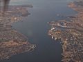
Aerial view of Sydney Harbour
-
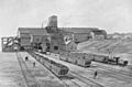
Reserve Colliery in 1900
-
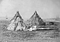
Mi'kmaq camp in Sydney, Cape Breton Island, Nova Scotia, photographed by Paul-Émile Miot in 1857.
