Cape Breton Highlands facts for kids
Quick facts for kids Cape Breton Highlands |
|
|---|---|
 |
|
| Highest point | |
| Peak | White Hill |
| Elevation | 533 m (1,749 ft) |
| Prominence | 533 m (1,749 ft) |
| Isolation | 151.6 km (94.2 mi) |
| Dimensions | |
| Length | 175 km (109 mi) N -S |
| Width | 143 km (89 mi) E - W |
| Geography | |
| Location | Cape Breton Island, Nova Scotia, Canada |
| Range coordinates | 46°44′59.5″N 60°35′53.7″W / 46.749861°N 60.598250°W |
| Parent range | Appalachian Mountains |
| Topo map | NTS O11/K10 |
| Geology | |
| Age of rock | Precambrian |
| Mountain type | Fault-block mountains |
| Climbing | |
| Access | road/hike |
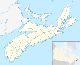
The Cape Breton Highlands (also called the Highlands) are a beautiful, mountainous area. They are found on the northern part of Cape Breton Island. This island is in Nova Scotia, a province in Canada. The Highlands are like a high, flat area called a plateau.
These Highlands are part of the larger Appalachian Mountains chain. They cover the northern parts of Inverness and Victoria counties.
Contents
Exploring the Cape Breton Highlands
Where the Highlands Are
The Cape Breton Highlands are almost completely surrounded by water. The Atlantic Ocean is to the east. The Cabot Strait is to the north and east. The Gulf of St. Lawrence is to the north and west. Finally, Bras d'Or Lake is to the south.
The land here is high. The edges of the plateau are about 350 metres (1,150 feet) above sea level. In the middle, the land rises to over 500 metres (1,640 feet). The highest point in Nova Scotia is here. It is called White Hill, and it is 533 metres (1,749 feet) tall.
What the Land Looks Like
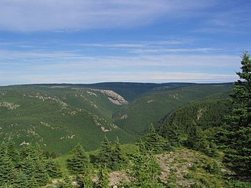
The Highlands plateau has many wide, gently rolling hills. Deep valleys and steep river canyons cut through these hills. The southern and western parts of the plateau have wide valleys. The soil there is good for farming because of ancient glaciation (when glaciers moved across the land).
Most of the inner and southern parts of the plateau have cool, damp forests. These forests are full of deciduous trees. This means their leaves change colour in autumn. It makes for amazing views! Higher up, above 300 metres (980 feet), you mostly see Balsam Fir trees. This is because the growing season is short and winters are harsh.
The northern and western edges of the plateau look like arctic tundra. This is a very cold, treeless area. The west coast of the Highlands has steep cliffs that meet the Gulf of St. Lawrence. The east coast has a gently sloping plain with low headlands and several beaches.
Protecting Nature and Exploring
In 1936, the Canadian government created the Cape Breton Highlands National Park. This park covers 950 square kilometres (367 square miles). It protects the northern part of the Highlands.
The Cabot Trail is a famous scenic highway. It goes all around the coastal edge of the plateau. Along the coast, you will find small fishing villages. There are also communities that welcome tourists.
The middle of the plateau has no public roads. Very few people live there. This makes it one of Nova Scotia's largest wilderness areas. It is a great place for nature and quiet.
Power from Water
The Wreck Cove Hydroelectric System is a large power plant. It is the biggest hydroelectric plant in Nova Scotia. It can make 215.8 megawatts of electricity.
This system was built between 1975 and 1978. It is south of the Cape Breton Highlands National Park. Wreck Cove collects water from a large area of the Highlands plateau. This water is used to create clean, renewable electricity.
 | Audre Lorde |
 | John Berry Meachum |
 | Ferdinand Lee Barnett |


