White Hill (Nova Scotia) facts for kids
Quick facts for kids White Hill |
|
|---|---|
| Highest point | |
| Elevation | 535 m (1,755 ft) |
| Prominence | 535 m (1,755 ft) |
| Isolation | 151.6 km (94.2 mi) |
| Listing | |
| Geography | |
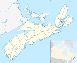
| Location | Victoria County, Nova Scotia |
| Parent range | Cape Breton Highlands |
| Topo map | NTS O11/K10 |
| Climbing | |
| Easiest route | Hike |
White Hill is a mountain in Canada. It is the highest point in the province of Nova Scotia. This makes it a very special place!
This peak is part of the Cape Breton Highlands. It is located on a high, flat area about 15 kilometers (9 miles) northwest of Ingonish. It is also about 33 kilometers (20 miles) northeast of Cheticamp.
White Hill is found inside the Cape Breton Highlands National Park. You can only reach it by hiking. It is a very remote spot. The hill is large and flat, covered with small spruce trees. It rises from a wet, open, and windy area. The closest road is about 20 kilometers (12 miles) away. The nearest hiking trails are about 10 kilometers (6 miles) away.
Contents
What is White Hill?
White Hill is the highest natural point in Nova Scotia. It stands tall at 535 meters (1,755 feet) above sea level. It is part of the beautiful Cape Breton Highlands mountain range. This area is known for its stunning views and wild nature.
Exploring White Hill
Getting to White Hill is an adventure! Since it is in a national park, it is protected. The only way to visit the very top is by hiking. Because it is so far from roads and trails, it is a great place for experienced hikers. They can enjoy the quiet and untouched wilderness.
Survey Marker at the Top
What is a Survey Marker?
At the very top of White Hill, there is a special marker. It is called a survey station. This marker helps mapmakers and scientists. They use it to measure distances and heights very accurately. It is like a fixed point that helps them understand the shape of the Earth.
History of the Marker
The survey marker on White Hill is a brass or bronze disk. It is set into a concrete block. This block sits on a small rock outcrop. The marker was first put there in June 1923. It was updated in 1963 to keep it accurate. Scientists checked on it using helicopters in 1976 and 1987. There used to be a metal tower marking the spot, but it fell down around 2008.
 | John T. Biggers |
 | Thomas Blackshear |
 | Mark Bradford |
 | Beverly Buchanan |


