Cabot Strait facts for kids
Quick facts for kids Cabot Strait |
|
|---|---|

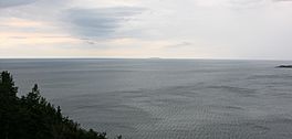
Cabot Strait from White Point, Cape Breton Island. St. Paul Island in the distance.
|
|
| Location | Cape Breton Island, Nova Scotia & Newfoundland |
| Coordinates | 47°15′00″N 59°45′00″W / 47.25000°N 59.75000°W |
| Type | Channel |
| Part of | Gulf of Saint Lawrence |
| Ocean/sea sources | Atlantic ocean |
| Basin countries | Canada |
| Max. length | 20 nautical miles (37 km; 23 mi) |
| Max. width | 70 nautical miles (130 km; 81 mi) |
| Max. depth | 550 metres (1,800 ft) |
| Islands | St. Paul Island (Nova Scotia) |
| Trenches | Laurentian Channel |
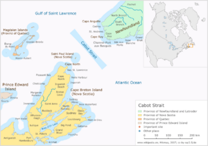
The Cabot Strait (in French: détroit de Cabot) is a wide passage of water in eastern Canada. It is about 110 kilometres (68 miles) wide. This strait connects Cape Ray in Newfoundland and Cape North on Cape Breton Island.
The Cabot Strait is the largest of three ways the Gulf of Saint Lawrence connects to the Atlantic Ocean. The other two are the Strait of Belle Isle and the Strait of Canso. The strait is named after John Cabot, an explorer from Genoa.
Contents
Exploring the Strait's Depths
The bottom of the Cabot Strait is quite varied. A deep underwater valley called the Laurentian Channel runs through its middle. Closer to Newfoundland and Cape Breton Island, the water is much shallower.
These different depths can sometimes cause very large and unexpected waves. These are known as rogue waves. In 1929, a huge underwater landslide happened here. It was caused by the 1929 Grand Banks earthquake. This landslide led to a tsunami that hit the coasts of Newfoundland and Cape Breton Island.
A Key Waterway
The Cabot Strait has always been a very important waterway for Canada and Newfoundland. It is also a major route for ships from all over the world. It is the main path linking the Atlantic Ocean to ports far inland. These ports are found on the Great Lakes and along the Saint Lawrence Seaway.
Travel and Communication
Today, a Marine Atlantic ferry service crosses the strait every day. These ferries connect Channel-Port aux Basques in Newfoundland with North Sydney, Nova Scotia. Ferries have been sailing across the strait since 1898.
Long ago, in 1856, an underwater telegraph cable was laid here. This was part of a bigger project to lay a transatlantic telegraph cable across the entire Atlantic Ocean.
Island History
St. Paul Island (Nova Scotia) is an infamous spot in the strait. During the time of sailing ships, many vessels were wrecked there. Because of this, people called it the "Graveyard of the Gulf" (of St. Lawrence).
World War II Events
During World War II, the Cabot Strait saw some tragic events.
- In October 1942, a German U-boat (submarine) sank the ferry SS Caribou. The ferry was not lit up at night, and 137 people lost their lives.
- On November 25, 1944, another German U-boat sank the Canadian ship HMCS Shawinigan. All 91 crew members on board were lost.
See also
 In Spanish: Estrecho de Cabot para niños
 | Aaron Henry |
 | T. R. M. Howard |
 | Jesse Jackson |


