
Strait of Belle Isle facts for kids
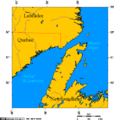
The Strait of Belle Isle (which means "Beautiful Island Strait" in French) is a waterway in eastern Canada. It separates the Labrador Peninsula from the island of Newfoundland in the province of Newfoundland and Labrador. This strait is an important natural passage connecting different parts of the ocean.

Contents
Where is the Strait of Belle Isle?
The Strait of Belle Isle is like a northern exit for the Gulf of Saint Lawrence. The other two exits are the Cabot Strait and the Strait of Canso. Because of this, it's also considered part of the bigger Great Lakes-St. Lawrence Seaway system, which helps ships travel far inland.
The strait is about 125 kilometers (78 miles) long. Its width changes quite a bit, from its widest point at 60 kilometers (37 miles) to its narrowest at just 15 kilometers (9 miles). On average, it's about 18 kilometers (11 miles) wide.
How did the Strait of Belle Isle get its name?

The name "Belle Isle" comes from a small island called Belle Isle. This island is located at the far eastern end of the strait. "Belle Isle" means "Beautiful Island" in French. The island is roughly halfway between Table Head in Labrador and Cape Bauld in Newfoundland.
Who lived in the Strait of Belle Isle area?
For thousands of years, Indigenous Peoples have lived on the island of Newfoundland and in the Labrador region around the Strait of Belle Isle. The land here was historically full of animals like caribou and other mammals. The strait itself is home to many aquatic animals, including harbour seals, grey seals, and ringed seals.
An old manuscript mentions that Vikings might have known about this area. They called Labrador "Markland" and Newfoundland "Vinland." The manuscript seems to describe the Strait of Belle Isle, saying: "And if such is the case, then an ocean flows into a strait between Markland and Vínland."
Basque whalers, who were skilled sailors from a region in Europe, visited this area in the 1600s and early 1700s. They hunted whales here. The remains of a ship called the San Juan, found at Red Bay, show that they were here as early as 1565. These Basque sailors also met the Inuit people. Sometimes they worked together, and sometimes they had conflicts over hunting areas.
Traveling through the Strait of Belle Isle can be very challenging. There are strong ocean currents that mix with the cold Labrador Current. The water can be very deep in some places. For 8 to 10 months of the year, there is sea ice, which makes shipping difficult. The weather can also be tricky, with strong winds and fog.
Even though sea ice stops ships from traveling all year, the Canadian Coast Guard helps keep things safe. They have a special service that helps prevent collisions between vessels.
A ferry service operates in the western part of the strait. This ferry connects St. Barbe in Newfoundland with Blanc Sablon in Quebec. In 2002, new roads were built for the Trans-Labrador Highway, which meant some ferry services to smaller coastal communities were no longer needed.
Could there be a fixed link across the Strait?
People have often talked about building a fixed link (like a bridge or tunnel) across the Strait of Belle Isle. This idea has come up many times over the past few decades. In the mid-1970s, there was an attempt to build a tunnel for electrical wires, but it didn't work out.
If a fixed link were built today, it would likely be a 17-kilometer (11-mile) long underwater rail tunnel. This tunnel would carry trains that could transport vehicles. The main reason for this project would be to make the province less dependent on the Marine Atlantic ferry service to Nova Scotia. However, the project would be very expensive, and there aren't enough good roads connecting Labrador to Quebec, which are big challenges.
In 1975, the government led by Frank Moores started building a tunnel across the strait. They dug a hole on the Labrador side and spent about $75 million before the project was stopped.
In 2003, the new government decided to fund a study about the idea of a fixed link. A report in 2005 suggested that a tunnel built with special boring machines, using an electric train shuttle for vehicles, would be the best option. At that time, the estimated cost to build it was about $1.2 billion (in 2004 Canadian dollars), with a total development cost of about $1.7 billion.
In 2016, Premier Dwight Ball started another study to figure out the costs of a tunnel. The study's results came out in April 2018. It suggested that a 16-kilometer (10-mile) undersea rail tunnel could connect L'Anse Amour in southern Labrador with Yankee Point near Flower's Cove on the Northern Peninsula of Newfoundland. The estimated cost for this was C$1.65 billion.
In their election plans for 2019, the Liberal Party of Canada showed support for a National Infrastructure Fund. This fund could include the Newfoundland-Labrador fixed transportation link, possibly connecting Yankee Point, Newfoundland, with Point Amour on the Labrador mainland.
Currently, a 35-kilometer (22-mile) underwater cable is being built across the strait as part of the Lower Churchill Project. This cable will help carry electricity.
Images for kids
-
Strait of Belle Isle
-
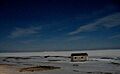
Looking across the Strait of Belle Isle in moonlight from Green Island Brook. You can see Point Amour light, L'Anse-au-Loup, and Capstan Island.
See also
 In Spanish: Estrecho de Belle Isle para niños
