Cape Bauld facts for kids
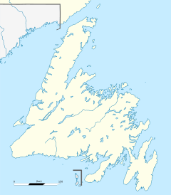
Cape Bauld is a special piece of land that sticks out into the ocean. It's located at the very northernmost point of Quirpon Island. This island is just northeast of the Great Northern Peninsula of Newfoundland in the Canadian province of Newfoundland and Labrador. Think of it as the tip of a finger pointing out into the sea!
Cape Bauld is slightly north and east of another place called Cape Norman. It marks the eastern end of the Strait of Belle Isle, which is a narrow passage of water.
This area has a very long history. An English explorer named John Cabot might have landed at Cape Bauld on June 24, 1497. However, another place called Cape Bonavista is also thought to be a possible landing spot for him. What's really cool is that Cape Bauld is only about nine kilometers (5.6 miles) northeast of a confirmed Viking site. This site, called L'Anse-aux-Meadows, dates back five centuries before Cabot's journey! It shows that people were exploring this area long, long ago.
The Cape Bauld Lighthouse
| Location | Cape Bauld Quirpon Island Newfoundland Canada |
|---|---|
| Coordinates | 51°36′24.4″N 55°25′38.4″W / 51.606778°N 55.427333°W |
| Year first constructed | 1884 (first) |
| Year first lit | 1962 (current) |
| Deactivated | 1962 (first) |
| Foundation | concrete base |
| Construction | wooden tower (first) concrete tower (current) |
| Tower shape | quadrangular tower (first) octagonal frustum tower with balcony and lantern (current) |
| Markings / pattern | with tower, red lantern |
| Height | 14.6 metres (48 ft) |
| Focal height | 54 metres (177 ft) |
| Range | 17 nautical miles (31 km; 20 mi) |
| Characteristic | Fl W 15s. |
| Admiralty number | H0132 |
| CHS number | CCG 225 |
| NGA number | 1052 |
| ARLHS number | CAN-652 |
A lighthouse was first built at Cape Bauld in 1884. Lighthouses are important because they help guide ships safely, especially at night or in bad weather.
The lighthouse you see there today is actually the second one built. It was constructed between 1960 and 1961. The house where the lightkeeper used to live was built even earlier, in 1920.
 | Bayard Rustin |
 | Jeannette Carter |
 | Jeremiah A. Brown |


