L'Anse aux Meadows facts for kids
Quick facts for kids L'Anse aux Meadows |
|
|---|---|
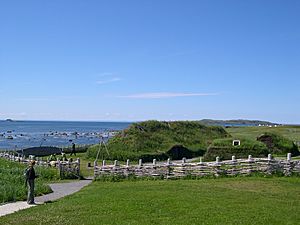
Recreated Norse buildings at L'Anse aux Meadows
|
|
| Official name: L'Anse aux Meadows National Historic Site |
|
| Type | Cultural |
| Criteria | vi |
| Designated | 1978 (2nd session) |
| Reference no. | 4 |
| Country | Canada |
| Region | Europe and North America |
| Official name: L'Anse aux Meadows National Historical Site of Canada. | |
| Designated | 28 November 1968 |
| Lua error in Module:Location_map at line 420: attempt to index field 'wikibase' (a nil value). | |
L'Anse aux Meadows is an amazing archaeological site in Newfoundland, Canada. It's where experts found the remains of a Norse settlement that is about 1,000 years old. This makes it the first known place where Europeans lived in North America, long before Christopher Columbus arrived!
This special site is located on the very northern tip of Newfoundland. It's in the Canadian province of Newfoundland and Labrador, close to a town called St. Anthony.
Scientists used methods like carbon dating and tree-ring dating to figure out when the Norse lived here. They found that the settlement was active around the year 1021. This proves that the Norse were the first Europeans to reach the Americas (outside of Greenland).
L'Anse aux Meadows is important because it shows us that the Norse explored North America. It might even be connected to the famous stories of Leif Erikson found in old Viking tales. Archaeologists believe this settlement was a base camp for their explorations.
The site covers a large area of land and sea. It contains the remains of eight buildings made from sod (grass and soil) over wooden frames. Over 800 Norse objects have been found here. These include items made of bronze, bone, and stone. There is also evidence that the Norse made iron at this site.
Because of its historical importance, L'Anse aux Meadows was named a National Historic Site of Canada in 1968. It also became a World Heritage Site by UNESCO in 1978. Today, Parks Canada helps to protect and manage this incredible place.
Contents
What's in a Name?
The name L'Anse aux Meadows sounds French, and it means "Grassland Bay." It literally translates to "the bay with the grasslands." People have different ideas about how the village got this name.
Some think it might be a changed version of the French L'Anse aux Méduses, which means "Jellyfish Cove." Another idea is that it comes from L'Anse à la Médée (Medea Cove). This name appeared on a French map from 1862. The English word "Meadows" likely came from the grassy, open landscape around the bay.
A Look Back in Time
Early People of the Land
Long before the Norse arrived, different Indigenous groups lived at L'Anse aux Meadows. Evidence shows that five different groups occupied the site. The oldest signs of people here date back about 6,000 years.
None of these Indigenous groups were living there at the same time as the Norse. The most well-known group was the Dorset people. They lived at the site about 300 years before the Norse arrived.
The Norse Arrive
The Norse settlement at L'Anse aux Meadows was built around the year 1000 CE. Scientists used special dating methods to confirm this. A study in 2021 used tree ring samples to pinpoint the exact year 1021 for Norse activity.
Some experts believe the Norse stayed at the site for about 20 years. Others think it might have been used for up to a century. It was likely a temporary base, not a permanent town. There are no signs of burials, farming, or animal pens. This suggests the Norse left the site in an organized way.
We don't know exactly how many people lived there at one time. The buildings could hold between 30 and 160 people. The entire Norse population in Greenland at that time was about 2,500. So, L'Anse aux Meadows was a smaller outpost.
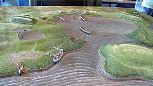
Today, the area is mostly open and grassy. But 1,000 years ago, there were forests. These forests were perfect for building boats, houses, and for getting iron. Archaeologists found the remains of eight buildings. They were likely made of sod placed over wooden frames.
These buildings were used as homes or workshops. The largest building was a hall with several rooms. Three smaller buildings might have been workshops or living areas for crew members. One workshop was an iron smithy, where they made iron. Another was a carpentry workshop, where they worked with wood.
Other items found include a stone oil lamp, a whetstone (for sharpening tools), and a bronze pin. They also found a bone needle and part of a spindle. These tools suggest that women, as well as men, lived at the settlement.
The Norse ate many different foods. They hunted caribou, wolves, foxes, bears, and many types of birds and fish. They also ate seals, whales, and walruses. They even found butternuts, which grow much farther south. This means the Norse traveled to other areas to gather food.
How the Site Was Found
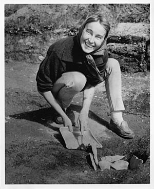
The remains of the Norse buildings were discovered in the 1960s. A Norwegian husband-and-wife team, explorer Helge Ingstad and archaeologist Anne Stine Ingstad, led the discovery. They excavated the site from 1961 to 1968.
Before their discovery, historians thought the Norse land called "Vinland" (meaning "wine-land") had to be in a place with wild grapes. This meant it would be much farther south, like the coast of Massachusetts.
The Ingstads thought differently. They believed "Vinland" might mean "land of meadows." This idea led them to explore northern Newfoundland. In 1960, a local fisherman named George Decker showed Helge Ingstad some grassy mounds. Locals called them the "old Indian camp." These mounds looked like old house remains.
The Ingstads' team dug up the site and found the remains of eight buildings. They also found many artifacts. These discoveries proved that it was a Norse settlement. The items matched those found in Norse sites in Greenland and Iceland from around 1000 CE.
L'Anse aux Meadows is the only confirmed Norse site in North America outside of Greenland. It shows how far Europeans explored before Columbus. Some historians think there might be other Norse sites or trade spots in the Canadian Arctic. However, L'Anse aux Meadows remains the only proven settlement.
A National Historic Site Today
In November 1968, the Government of Canada officially named L'Anse aux Meadows a National Historic Site of Canada. Then, in 1978, UNESCO declared it a World Heritage Site.
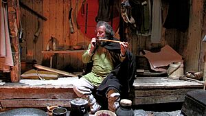
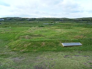
Today, Parks Canada manages the site and its visitor programs. After the first big excavation, more digs happened in the 1970s. After each dig, the site was reburied to protect the old remains.
Visitors can see the remains of seven Norse buildings. There are also recreated buildings built in the late 20th century. These help visitors imagine what the settlement looked like. You can also find picnic areas and a visitor centre at the site.
Stories of Vinland
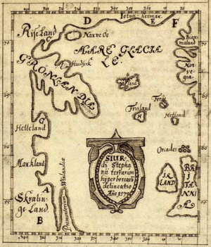
In 1073, a German writer named Adam of Bremen wrote about "Vinland." This is the oldest known document to mention this mysterious land. He wrote about an island where vines grew and produced excellent wine.
Two old Icelandic sagas (stories), the Saga of the Greenlanders and the Saga of Erik the Red, also tell tales of Norse explorers. These stories describe how Norse people from Greenland discovered a land to the west. They called it Vinland.
The sagas tell of arguments among the Norse settlers. They also describe fights with the native people, whom they called Skrælings. These conflicts eventually led the Norse to leave their settlements.
Some people believe that L'Anse aux Meadows could be one of the Vinland settlements mentioned in these sagas. It might be "Leifsbudir," founded by Leif Erikson, or "Hóp." However, experts still debate the exact connection between the sagas and the archaeological site.
Images for kids
See also
 In Spanish: L'Anse aux Meadows para niños
- Former colonies and territories in Canada
- History of Newfoundland and Labrador
- List of National Historic Sites of Canada in Newfoundland and Labrador
- List of oldest buildings in Canada
- List of World Heritage Sites in Canada
- Norse colonization of North America
- St. Barbe-L'Anse aux Meadows
- Thorfinn Karlsefni
- Vinland Map
 | Jewel Prestage |
 | Ella Baker |
 | Fannie Lou Hamer |


