Skálholt facts for kids
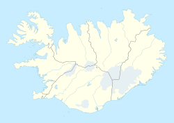
Skálholt is a very old and important place in the south of Iceland. It sits by the Hvítá River.
Contents
Skálholt: A Center of History in Iceland
For over 800 years, Skálholt was one of the most important places in Iceland. It became a special religious center called a bishopric in 1056. Until 1785, it was one of Iceland's two main church headquarters, along with Hólar. This made Skálholt a very important place for culture and politics.
The First School in Iceland
Iceland's first official school, Skálholtsskóli, started in Skálholt in 1056. Its main goal was to teach people who wanted to become priests. Today, a famous school in Reykjavík, Reykjavík Gymnasium, is considered its successor. In 1992, the old school in Skálholt was reopened. It now works as an education and information center for the Church of Iceland.
Life in Skálholt During the Middle Ages
During the Middle Ages, Skálholt was a very busy place. Besides the bishop's office, there was a big church (a cathedral), and the school. People also farmed a lot, and there was a place to make things from metal (a smithy). When Iceland was still Catholic, there was even a monastery here. Many buildings made up the town, including places for students, teachers, and workers. Around the year 1075, a writer named Adam of Bremen called Skálholt the "largest city" in Iceland.
At first, the church district of Skálholt was connected to a larger church area in Germany. Later, it became part of the church area of Lund in Sweden, and then Nidaros in Norway.
Changes After the Reformation
Skálholt remained an important church center even after the country changed from Catholicism to Lutheranism. This change, called the Reformation, brought an end to Catholicism in Iceland. A sad event happened in 1550 when the last Catholic bishop, Jón Arason, was put to death in Skálholt along with his two sons. The special container holding the remains of St. Thorlac, who was the sixth bishop of Skálholt, was also destroyed in 1550. His remains were scattered around the church grounds.
Even though Skálholt and Hólar are no longer the main church headquarters in the same way, their old churches are still used by two special bishops of the Church of Iceland.
Visiting Skálholt Today
Many people visit Skálholt every year. The Skálholtsskóli also offers places for visitors to stay in its dorms, rooms, and small houses. Many cultural events, like concerts, are held here. The most famous event is the Summer Concerts program in July. During this time, famous classical musicians, choirs, and other artists come to perform.
The Cathedral of Skálholt
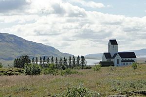
The church building in Skálholt today is quite large compared to most churches in Iceland. It is about 30 meters long from the front door to the back. Some of the older churches that stood here before were even longer, reaching up to 50 meters!
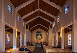
The current cathedral was built between 1956 and 1963. This was part of a big celebration for the 1000-year anniversary of the bishopric. Other churches in Scandinavian countries helped celebrate with Iceland. Many things inside the new cathedral are gifts from them. For example, the beautiful stained glass windows, made by Gerður Helgadóttir, were a gift from the people of Denmark.
The Skálholt Map and Norse Discoveries
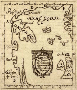
In the late 1500s, a young teacher from Skálholt named Sigurd Stefánsson created an important map. Sigurd was the grandson of a Skálholt bishop. He used old documents to mark the places where the ancient Norse people had explored in the western Atlantic Ocean, including a place called Vinland. Sigurd studied at the University of Copenhagen before becoming a teacher at the former monastery in Skálholt. Skálholt remained a center for religion and education in Iceland even after Protestantism was introduced in 1551.
What the Skálholt Map Shows
The original map Sigurd made in 1570 is no longer around. However, a copy was made in 1690 by Þórður Þorláksson, who was also a Bishop of Skálholt. This copy is now kept in the Danish Royal Library. Many other copies were made by scholars in Scandinavia.
By comparing the map's latitude lines with those of the British Isles, the map shows the northern tip of "Vinland" at about 51 degrees north. This is the same latitude as the southern tip of Ireland and Bristol, England. When this information was put onto modern maps, it showed that Sigurd had marked the northern tip of Newfoundland as Vinland. This was one of the reasons that encouraged archaeologists Anne Stine and Helge Ingstad to search for Norse settlements. In the 1960s, their successful digs at L'Anse aux Meadows proved that the Norse had indeed been there.

* Land of the Risi (a mythical location)
* Greenland
* Helluland (Baffin Island)
* Markland (the Labrador Peninsula)
* Land of the Skræling (location undetermined)
* Promontory of Vinland (the Great Northern Peninsula)
See also
 In Spanish: Skálholt para niños
 | Madam C. J. Walker |
 | Janet Emerson Bashen |
 | Annie Turnbo Malone |
 | Maggie L. Walker |


