Former colonies and territories in Canada facts for kids
Before Canada became the country we know today, many different countries claimed parts of its land. Long ago, before Europeans arrived, various Indigenous groups lived across North America. Some lived in small groups in the North, while others formed larger alliances of hunting bands in the Plains. In the Great Lakes region, there were structured groups of farming villages. Along the Pacific Coast, fishing communities had complex family structures.
European exploration of what is now Canada started around the 10th century when Norsemen (Vikings) tried to settle in the northeastern parts of North America, but they didn't stay. Later, in the late 1500s and 1600s, permanent European settlements began. These included French colonies like Acadia and New France, and English colonies like Newfoundland (island) and Rupert's Land. There were also Scottish colonies in Nova Scotia and Port Royal.
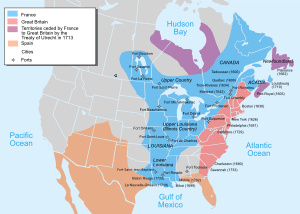
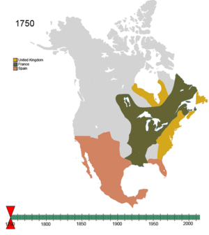
In 1763, after a big war called the Seven Years' War, France lost almost all its colonies in North America to the British Empire. Over a century later, in 1867, Britain gave control of the land to Canada after Confederation. Since then, Canada's borders have changed many times. It started with four provinces and has grown to ten provinces and three territories by 1999.
Indigenous Peoples of Canada
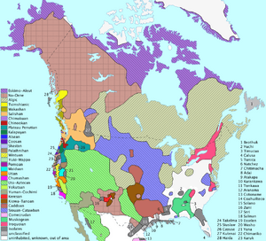
Indigenous peoples in what is now Canada did not form countries in the same way European nations did. Instead, experts often group them by their traditional "lifeway" (how they got food) and the climate of their region. These groups are called "culture areas." They can also be grouped by their language families.
The Mi'kmaq people in today's Maritimes had seven separate areas, each with its own chief and council. These councils met once a year on Cape Breton Island. After their first conflict with the British in 1677, the Mi'kmaq joined the Wabanaki Confederacy. This was an alliance with four other nations: the Abenaki, Penobscot, Passamaquodky, and Maliseet.
To the west, around the Great Lakes, the Council of Three Fires was formed in 796 CE. This alliance included the Ojibwa, Odawa, and Potawatomi nations. The Iroquois Confederacy united five (and later six) tribes in 1142 CE. The Huron Confederacy also existed in the Great Lakes region, made up of four or five tribes.
In present-day Alberta and Montana, the Blackfoot Confederacy started with three groups speaking the same language. Later, the Sarcee people, who spoke a different language, joined them. The Iron Confederacy in Alberta and Saskatchewan included many groups of Plains Cree, Assiniboine, and Saulteaux people.
The Indigenous peoples of the Pacific Northwest Coast and peoples of the Northwest Plateau had very organized cultures. They lived in fairly large populations. Many cultures in these regions were similar, especially in how important fishing was to their communities.
- Arctic Culture Area: These groups, like the Inuit, spoke Eskimo–Aleut languages.
- Subarctic Culture Area: Peoples here spoke Na-Dene languages and Algic languages.
- Eastern Woodlands (Northeast) Culture Area: Groups in this area spoke Algic languages and Iroquoian languages.
- Plains Culture Area: These included groups speaking Algic languages, Na-Dene languages, and Siouan–Catawban languages.
- Northwest Plateau Culture Area: Peoples here spoke Salishan languages and Kutenai language.
- Northwest Coast Culture Area: These groups spoke Penutian languages, Tsimshianic languages, and Wakashan languages.
European Colonization
Europeans began exploring and settling North America over many centuries.
Norse Settlement
The Norse (Vikings) had colonies in Greenland for almost 500 years. However, their settlements on mainland North America were small and did not last. Vinland, Markland, and Helluland are names for three lands, possibly in Canada, that Norsemen discovered. These are described in old sagas like the Eiríks saga rauða and Grœnlendinga saga.
- L'Anse aux Meadows: This is a known Norse settlement, and carbon dating suggests it was active around 990–1050 CE.
Portuguese Claims
Portugal believed it had rights to the Atlantic waters explored by John Cabot in 1497 and 1498. This was based on the Treaty of Tordesillas. From 1498 to 1500, Portuguese sailor João Fernandes Lavrador explored the North Atlantic coast. This is why the name "Labrador" appears on maps from that time. In 1501 and 1502, Miguel and Gaspar Corte-Real explored what is now Newfoundland. They claimed the land for the Portuguese Empire.
It's not clear how much Portuguese activity happened on the Canadian mainland in the 1500s. However, it's believed that explorer Joao Álvarez Fagundes tried to set up a seasonal fishing colony. We don't know exactly where or for how long this fishing post existed. In 1585, an English expedition led by Bernard Drake destroyed the Portuguese and Spanish fishing industries in the area. They never fully recovered.
New France
In 1534, Jacques Cartier placed a cross on the Gaspé Peninsula. He claimed the land for Francis I of France. In 1600, a trading post was set up at Tadoussac. But only five of sixteen settlers survived the first winter. In 1604, the first year-round settlement was founded by Samuel de Champlain at Île-Saint-Croix. This settlement was moved to Port-Royal in 1605. In 1608, Samuel de Champlain founded Québec City. Out of 28 men, 20 died from lack of food and scurvy during the first winter.
- New France (1534–1763): This was the overall name for French colonies.
- Acadie (1604–1713)
- Canada (New France) (1608–1763)
- Terre Neuve (Newfoundland) (1610–1713)
- Île Royale (Cape Breton) (1713–1763)
- Isle Saint-Jean (Prince Edward Island) (1713–1763)
- Pays d'en Haut (1639–1763)
- Illinois Country (1673–1717)
British North America
British colonization began in the late 1500s. This included efforts by both the Kingdom of England and Kingdom of Scotland before they united in 1707 to form the Kingdom of Great Britain. Britain gained the French colony of Acadia in 1713, and later Canada, New France.
The United Kingdom also claimed the west coast of North America. This was through fur trading companies like the North West Company and Hudson's Bay Company. These companies operated in areas like the Columbia District and New Caledonia. Much of this land was also claimed by the United States, who called it the Oregon Country. In 1846, the 49th parallel became the border west of the Rocky Mountains.
The Colony of Vancouver Island was founded in 1849. The Colony of British Columbia was founded in 1858. These two colonies combined in 1866 and joined Canada in 1871. British Columbia also grew by adding the Colony of the Queen Charlotte Islands and most of the Stikine Territory in 1863. When it joined Canada, it also gained the Peace River Country.
- British America (1583–1783)
- St. John's, Newfoundland (from 1583, English)
- British Arctic Territories (from 16th century)
- Cuper's Cove, Newfoundland (from 1610, English)
- Avalon, Newfoundland (from 1610, English)
- Renews, Newfoundland (from 1615, English)
- Bristol's Hope, Newfoundland (from 1618, English)
- Nova Scotia (1621–2, Scottish)
- Cape Breton (1625, Scottish)
- Saint John, New Brunswick (from 1631, English)
- Port Royal Colony (1629–1632, Scottish)
- Rupert's Land (from 1670)
- Nova Scotia (from 1710)
- Prince Edward Island (from 1763)
- Cape Breton (from 1763)
- Province of Quebec (from 1763)
- British North America (1783–1907)
- North-Western Territory (1783–1870)
- New Brunswick (1784–1867)
- The Canadas (Lower Canada and Upper Canada) (1791–1841)
- Columbia District (also called Oregon Country) (1793–1846)
- New Caledonia (1808–1858)
- Red River Colony (1811–1870)
- Province of Canada (1841–1867)
- Colony of Vancouver Island (1849–1866)
- Colony of the Queen Charlotte Islands (1853–1858)
- Colony of British Columbia (1858–1866)
- Stickeen Territories (1862)
- Colony of British Columbia (1866–1871)
- Dominion of Newfoundland (1907–1949)
New Spain
Spanish explorers were the first to explore the Pacific Northwest coast. Juan José Pérez Hernández made voyages in 1774 and 1775. Spain did this because they heard that Russians were exploring the Pacific Coast of North America. Spain considered this area part of New Spain.
- Santa Cruz de Nuca and Fort San Miguel at Nootka Sound (1789–1795): This was the first colony in British Columbia and the only Spanish settlement in what is now Canada.
Russian America
In 1799, Tsar Paul I of Russia claimed land and set up the Russian American Company. This company controlled trade in the North Pacific. Russia claimed land as far south as 51 degrees north latitude, which is near Cape Scott Provincial Park on Vancouver Island.
Even though no Russian settlements were built in what is now British Columbia, Russian ships often visited the North Coast for trade and science. After talks with the U.S. and Britain, Russia signed treaties in 1824 and 1825. These treaties set the new southern border of Russian territories at 54 degrees, 40 minutes north latitude. This is near Cape Muzon at the southern tip of Dall Island, in what is now the Alaska Panhandle.
Dutch Claims
The colony of New Netherland was started in 1614 by the Dutch West India Company. It covered most of what is now New York State. Its purpose was to give the Dutch access to the North American fur trade. It was governed from New Amsterdam (now New York City). The Dutch officially claimed territory as far north as the St. Lawrence River. This meant much of modern-day Quebec was part of their claim.
Even though no Dutch settlements were made in Quebec, it was officially part of New Netherland and the Dutch Empire. Also, during the Franco-Dutch wars in the 1670s, the Dutch captured several forts in Acadia. They called this area New Holland. There wasn't much settlement there, but the Dutch claims lasted for a few years.
Canada's Borders Changing Over Time
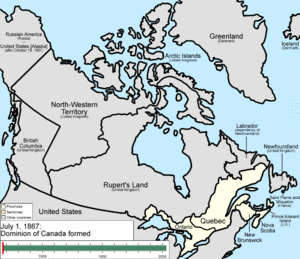
Canada became a country with its own government in 1867. This happened with the Constitution Act, 1867. At first, three British North American provinces – New Brunswick, Nova Scotia, and the Province of Canada (which became Ontario and Quebec) – joined together. Canada became fully independent with the Statute of Westminster 1931 in 1931 and the Canada Act in 1982.
Since 1867, Canada's outer borders have changed many times. It grew from four original provinces to ten provinces and three territories by 1999. This growth also involved agreements with Indigenous peoples, known as Numbered Treaties.
- North-West Territories (1870–1906)
- District of Keewatin (1876–1905)
- Yukon Territory (1898–2003)
Alaska Boundary Dispute
The Alaska boundary dispute had been an issue since the Alaska purchase in 1867. It became very important when gold was found in Yukon in the late 1890s. Canada wanted its own port on the Pacific Ocean that was connected to the gold fields. Canada argued that its historic border with Russian America included the Lynn Canal and the port of Skagway. Both of these were occupied by the U.S. The U.S. claimed the Atlin District and the lower Stikine River, and even Whitehorse. The disagreement went to a special group for a decision in 1903. The American claims were mostly supported because the British delegate sided with the Americans. This was done to keep a good relationship between Britain and the U.S.
Norwegian Claim
Otto Sverdrup, an explorer from Norway, claimed the Sverdrup Islands for Norway in 1902. However, the Norwegian government didn't show interest in this claim until 1928. On November 11, 1930, after Canada formally stepped in, Norway recognized Canada's ownership of the islands.
- Sverdrup Islands (1902–1930)
Danish Claim
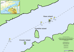
Hans Island is a small island in Kennedy Channel. It is a traditional hunting ground for the Inuit people. Both Canada and Denmark claim it. In 2007, new satellite photos led Canada to agree that the international border crosses through the middle of Hans Island, not just to its east.
- Hans Island (1933–present)
Northwest Passage
The Canadian government believes the Northwestern Passages are part of Canada's internal waters. However, the United States and several European countries say they are an international strait. This means they believe ships should have free passage through them.
Areas Disputed by the United States
Canada and the United States share the longest non-military border in the world. However, there have been many disagreements about where the border exactly lies.
Proposed Provinces and Territories
Since Canada became a country in 1867, there have been several ideas for new provinces and territories. To create a new province, the Constitution of Canada needs to be changed. But to create a new territory, only an act of Parliament is needed. This makes it easier to create a territory than a province.
 | Delilah Pierce |
 | Gordon Parks |
 | Augusta Savage |
 | Charles Ethan Porter |


