
Cape Scott Provincial Park facts for kids
Quick facts for kids Cape Scott Provincial Park |
|
|---|---|
|
IUCN Category II (National Park)
|
|

Forest trail near Laura Creek, Cape Scott Provincial Park
|
|

Cape Scott Provincial Park
Location in Vancouver Island

Cape Scott Provincial Park
Location in British Columbia
|
|
| Location | northern Vancouver Island, British Columbia |
| Area | 222.94 km² |
| Established | 1973 |
| Governing body | BC Parks |
Cape Scott Provincial Park is a beautiful natural area located at the very northern tip of Vancouver Island in British Columbia, Canada. This large provincial park stretches along the coastline, from Shushartie in the east, all the way around Cape Scott, and south to San Josef Bay. It covers about 22,294 hectares (that's like 223 square kilometers!). The park is quite far from big cities, located about 563 kilometers northwest of Victoria.
Contents
Who lived here first? First Nations and Explorers
Long before European explorers arrived, the land around Cape Scott was home to Indigenous peoples. The Yutlinuk people lived on the nearby Scott Islands until the early 1800s. The Nakomgilisala and Tlatlasikwala traditionally lived in the Cape Scott area. Today, these groups are part of the larger Kwakwaka'wakw Nation. There are still three First Nations reserves next to the park, including the site of the old village of Nahwitti.

In 1786, the cape was named after David Scott. He was a merchant from Mumbai (Bombay) who helped fund a fur trading trip to the Pacific Northwest Coast.
The Kwakwaka'wakw people knew the area well. They had special names for places like Experiment Bight and the sandy neck of land between Experiment Bight and Guise Bay. For example, the bight's name meant "whale between on beach." The sandy neck was called "against each other." To avoid the rough waters around the cape, the Kwakwaka'wakw would carry their canoes across this sandy neck.
Life in the Past: Early Communities
Imagine trying to start a new life in a wild, remote place! In 1897, a group of Danish-Canadian settlers tried to create a community near Cape Scott. They hoped it would be a perfect place to live. Their main settlement was about 6 kilometers east of the cape, at Hansen Lagoon. Supplies arrived at Fisherman's Bay, about 4 kilometers further east. They even built a wagon road to connect the two spots.
This small community grew to about 90 people. They had a general store, a community hall, and even a newspaper! They tried to farm by building dykes to reclaim land from the tidal flats. But big storms often destroyed their hard work.
Life was very tough. Fishing was difficult because they didn't have the right boats. Wild animals like cougars attacked their cattle and hunted away the game they relied on. Their supply boat, the Floyberg, was shipwrecked in 1899. The government had promised to build a road from Quatsino Sound, which would have helped them ship their farm goods. But the road was never built. This made it very hard for the community to survive.
By 1909, most people had left, with only two residents remaining. New Danish immigrants settled further south in the San Josef Valley. During World War I, even more people left to join the army.
Over the years, the communities slowly disappeared. Telephone lines were installed in 1915, connecting Holberg to Cape Scott and other small settlements. But the harsh environment was too much for most. Theodore Frederiksen, one of the first settlers at Fisherman's Bay, was also one of the last to leave. His property was bought by the government for a radar station in 1942. Alfred Spencer, a keen gardener, was the last person living at Hansen Lagoon. He ran a small store from his cabin, selling supplies to fishermen. He left in the mid-1950s. By the 1960s, San Josef Bay was also empty.
Today, if you visit these areas, you might see old collapsed buildings, rusty farm tools, old wells, and fence posts. These are the only reminders of the brave people who tried to make a home in this wild place.
Dangerous Waters: Shipwrecks
The waters around Cape Scott can be very rough, making it a dangerous place for ships. Many vessels have been wrecked here over the years.
- 1860: The ship Consort was wrecked at San Josef Bay.
- 1892: The schooner Maggie Mac broke apart, and pieces were found south of Cape Scott.
- 1896: The sealing schooner Wanderer was destroyed on rocks near San Josef Bay.
- 1908: The auxiliary schooner Clara C had an engine explosion and was wrecked off Cape Scott.
- 1910: The freighter St. Denis broke apart at sea, and sadly, 22 lives were lost. Debris from the ship washed ashore at Cape Scott.
- 1942: The tow barge "Fibreboard" was wrecked 15 nautical miles off Cape Scott.
- 1943: The freighter Northholm sank during a strong storm about one mile northwest of Cape Scott.
- 1946: The freighter Pelican I was sunk on purpose to act as a breakwater at Fisherman's Bay. But strong winds and waves pushed it ashore, where it slowly fell apart.
Exploring the Park: What to See and Do
.jpg)
Cape Scott Provincial Park was officially created in 1973. It's famous for its ancient, towering old growth forests and beautiful sandy beaches. The land is rugged, and the weather can be challenging, with lots of rain and strong storms. The highest point in the park is Mt. St. Patrick, which is 422 meters above sea level. The largest lake is Eric Lake, covering 44 hectares.
Over the years, the park has grown as the government bought more private land within its boundaries. This helps protect more of this special wilderness.
You can reach the eastern part of the park by boat or floatplane. In the summer, there's even a water taxi service from Port Hardy. To get to the western side, you can use the forest service roads from Port Hardy, through Holberg, to San Josef Bay.
Park Trails and Camping
The park has many trails for hikers. The main Cape Scott trails range from 2.5 to 23.6 kilometers long (one way) and are rated as easy to moderate. For more experienced hikers, the 43.1-kilometer North Coast Trail is a very difficult extension of the Cape Scott Trail. It's even part of the longer Vancouver Island Trail.
If you're planning to hike, remember that water sources can be far apart. Campsites usually have pit toilets and often have metal food caches to protect your food from animals. Some even have tent platforms to keep your tent off the wet ground. Because the park is becoming more popular, it's super important for everyone to pack out all their trash to keep it clean.
At San Josef Bay, there's a boat launch if you want to explore the coast by water.
Climate of Cape Scott
Cape Scott has a mild climate, meaning it doesn't get too hot or too cold. This is because it's on the west coast of the Pacific Ocean and is influenced by the Alaska Current. This ocean current helps keep temperatures from becoming too extreme throughout the year. However, it does get a lot of rain, especially in the fall and winter!
Images for kids
-
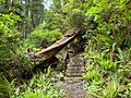
Forest trail near Laura Creek, Cape Scott Provincial Park
-
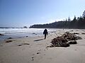
Experiment Bight, Cape Scott, 2009
-
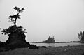
Sea stacks, Cape Scott, 2013
