
Dall Island facts for kids

Dall island and Cordova Bay photographed from Earth orbit
|
|
| Geography | |
|---|---|
| Location | Alaska |
| Coordinates | 54°57′22″N 133°03′33″W / 54.95611°N 133.05917°W |
| Archipelago | Alexander |
| Area | 254.02 sq mi (657.9 km2) |
| Highest elevation | 2,443 ft (744.6 m) |
| Administration | |
|
United States, Canada (point at tip)
|
|
| Demographics | |
| Population | 20 (2000) |
| Pop. density | 0.03 /km2 (0.08 /sq mi) |
Dall Island is a cool island located off the coast of Alaska. It's part of the Alexander Archipelago, a group of islands in the southeastern part of the state. It sits just west of Prince of Wales Island and is close to Canada.
This island is quite large, covering about 254 square miles (658 square kilometers). That makes it the 28th biggest island in the United States! Its highest point is about 2,443 feet (745 meters) above sea level. People use Dall Island for fishing and for getting limestone, which is a type of rock.
Contents
Who Lives on Dall Island?
In the year 2000, only 20 people lived on Dall Island. But long ago, the Haida lived here. They were known to use coastal caves on the island as homes about two to three thousand years ago.
Dall Island's History
Dall Island has an interesting past. It was first named "Quadra" in honor of Juan Francisco de la Bodega y Quadra, a Spanish explorer. But in 1879, its name was changed to Dall Island. This new name honored William Healey Dall, a famous naturalist. For a while, people even thought Dall Island was part of Prince of Wales Island!
Trading Post for Fur
During the time of the maritime fur trade, some harbors on the southeast side of Dall Island were very popular. These places, known as Kaigani, were busy trading spots. Fur trading ships would meet with the Kaigani Haida people there to trade goods.
The Border with Canada
Cape Muzon is the southernmost tip of Dall Island. This spot is very important because it marks the start of the water border between Alaska (in the United States) and British Columbia (in Canada). This border line is called the A–B Line. It was decided after a big discussion in 1903 about the Alaska boundary dispute.
This line also forms the northern edge of the waters known as the Dixon Entrance. The border at Cape Muzon was first set in 1825 by a treaty between Russia and Great Britain. Later, in 1903, a group of judges agreed that Cape Muzon was indeed the starting point for this important border.
Canada sees this A–B line as a clear international border. This means they believe the waters south of the line in Dixon Entrance are their own internal waters. However, the U.S. sees the A–B line as mainly defining who owns the land in the Dixon Entrance. They believe the waters are open to international laws, not just Canada's.
Logging on the Island
Dall Island is also used for its timber. There are many logging camps on the island. Companies like Columbia Helicopters from Oregon use helicopters to help cut and move timber from the island.
Images for kids
-
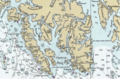
Dall Island is west of the southern part of Prince of Wales Island. It forms the western shore of Cordova Bay, Kaigani Strait, and Tlevak Strait.
-
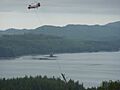
Helicopter logging on Dall Island.


See also
 In Spanish: Isla Dall para niños
