Belle Isle (Newfoundland and Labrador) facts for kids
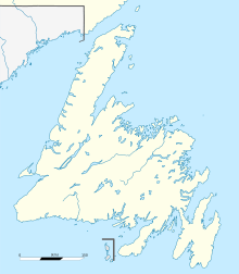
Belle Isle means "Beautiful Island" in French. It is an island that doesn't have anyone living on it permanently. It's located about 24 kilometers (15 miles) off the coast of Labrador and 32 kilometers (20 miles) north of Newfoundland. This island sits right at the Atlantic entrance to the Strait of Belle Isle, which is named after it.
The famous French explorer Jacques Cartier gave the island its name. Belle Isle is very important because it's on the shortest shipping route between the Great Lakes in North America and Europe. It's also a key spot on the main shipping path that goes north and south towards Hudson Bay and the Northwest Territories. The northern end of the International Appalachian Trail, a very long hiking path, is also found on Belle Isle.
Exploring Belle Isle

Belle Isle is about 17 kilometers (11 miles) long and 6 kilometers (4 miles) wide. It covers an area of about 52 square kilometers (20 square miles). The highest point on the island reaches about 213 meters (699 feet) high.
Even though it's officially uninhabited, some people stay on the island during the fishing season. This means they live there for a short time to fish.
There are lighthouses at both the northern and southern ends of Belle Isle. These lighthouses help guide ships safely through the busy waters.
Island's Unique Geography
Belle Isle is actually the northernmost peak of the Appalachian Mountains. These mountains are a huge chain that stretches over 3,200 kilometers (2,000 miles) southwest all the way to Alabama in the United States.
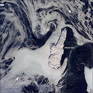
The way ice moves around Belle Isle shows that two big ocean currents meet there. The Labrador Current flows from the northwest. Another smaller current, pushed by strong westerly winds, comes from the southwest.
When you look at the sea ice, you can see how these currents move. Ice chunks in the Labrador Current look more spread out. But sea ice coming from the strait is much thicker and pushes against the west side of Belle Isle. The currents create interesting patterns around the island, with areas where the ice is clear on the side away from the current.
Weather and Climate
Belle Isle has a subarctic climate. This means it's very cold for a coastal place that's not too far north, around the 51st parallel north. For example, a city like Dunkirk in Europe, which is at a similar latitude, is much warmer. This difference is because of the different ocean currents on the eastern and western sides of the Atlantic Ocean.
The climate on Belle Isle has short, cool summers. The winters are very long and extremely cold, lasting for most of the year. Most of the rain falls during the warmer months, from June to September.
| Climate data for Belle Isle (1884-1969) | |||||||||||||
|---|---|---|---|---|---|---|---|---|---|---|---|---|---|
| Month | Jan | Feb | Mar | Apr | May | Jun | Jul | Aug | Sep | Oct | Nov | Dec | Year |
| Record high °C (°F) | 4.4 (39.9) |
4.4 (39.9) |
7.2 (45.0) |
13.3 (55.9) |
15.0 (59.0) |
20.6 (69.1) |
22.8 (73.0) |
22.2 (72.0) |
20.6 (69.1) |
14.4 (57.9) |
12.2 (54.0) |
7.2 (45.0) |
22.8 (73.0) |
| Mean daily maximum °C (°F) | −9.9 (14.2) |
−9.2 (15.4) |
−4.2 (24.4) |
−0.5 (31.1) |
3.6 (38.5) |
8.4 (47.1) |
13.5 (56.3) |
14.2 (57.6) |
10.5 (50.9) |
5.2 (41.4) |
−0.6 (30.9) |
−6.7 (19.9) |
2.0 (35.6) |
| Daily mean °C (°F) | −13.0 (8.6) |
−12.0 (10.4) |
−6.8 (19.8) |
−2.9 (26.8) |
1.4 (34.5) |
5.8 (42.4) |
10.6 (51.1) |
11.5 (52.7) |
8.1 (46.6) |
3.2 (37.8) |
−2.8 (27.0) |
−9.4 (15.1) |
−0.5 (31.1) |
| Mean daily minimum °C (°F) | −15.8 (3.6) |
−14.7 (5.5) |
−9.4 (15.1) |
−5.3 (22.5) |
−0.7 (30.7) |
3.2 (37.8) |
7.7 (45.9) |
8.9 (48.0) |
5.7 (42.3) |
1.2 (34.2) |
−5.0 (23.0) |
−12.0 (10.4) |
−3.0 (26.6) |
| Record low °C (°F) | −35 (−31) |
−34.4 (−29.9) |
−28.9 (−20.0) |
−23.3 (−9.9) |
−15.6 (3.9) |
−7.2 (19.0) |
−3.9 (25.0) |
−1.7 (28.9) |
−3.3 (26.1) |
−11.1 (12.0) |
−21.1 (−6.0) |
−34.4 (−29.9) |
−35 (−31) |
| Average precipitation mm (inches) | 59.6 (2.35) |
52.0 (2.05) |
110.7 (4.36) |
45.1 (1.78) |
90.8 (3.57) |
153.7 (6.05) |
161.0 (6.34) |
146.3 (5.76) |
135.2 (5.32) |
119.7 (4.71) |
84.4 (3.32) |
55.7 (2.19) |
1,214.2 (47.8) |
| Average precipitation days (≥ 0.1 mm) | 12.52 | 11.30 | 12.93 | 11.70 | 11.83 | 12.72 | 12.23 | 13.33 | 12.80 | 12.39 | 13.27 | 12.77 | 149.79 |
| Source: Météo Climat | |||||||||||||
 | Kyle Baker |
 | Joseph Yoakum |
 | Laura Wheeler Waring |
 | Henry Ossawa Tanner |


