
St. Paul Island (Nova Scotia) facts for kids
| Geography | |
|---|---|
| Location | Cape Breton, Nova Scotia, Canada |
.png)
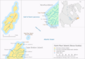
St. Paul Island (also called Île Saint-Paul in French) is a small island in Canada. It's not a place where people live. You can find it about 24 kilometers (15 miles) northeast of Cape North on Cape Breton Island. It's also about 71 kilometers (44 miles) southwest of Cape Ray on Newfoundland. The island sits right where the Gulf of St. Lawrence meets the Cabot Strait.
Contents
Discovering Saint Paul Island
St. Paul Island is part of the Appalachian Mountains and the Cape Breton Highlands. Its highest point is called "Croggan Mountain," which is 147 meters (485 feet) tall.
Long ago, the Miꞌkmaq people knew this island as Kuhtumuneggo. This name means "A Round Island." It is thought that John Cabot might have been the first European to find the island.
What the Island Looks Like
St. Paul Island is about three miles long and one mile wide at its widest part. It's made of granite rock and is very rugged. High rock cliffs surround the entire island. A narrow channel cuts through the island, filling with seawater.
Animals on the Island
The only wild mammals living on the island are rabbits. These rabbits were once pets but were set free after a lifesaving station was built there many years ago. The island is also home to many different seabirds. There are two small lakes inside the island that have trout fish.
The island's natural environment is very delicate. Because it can be dangerous to visit, you need special permission from the Canadian Coast Guard before going there. They look after the island for the Canadian government.
The "Graveyard of the Gulf"
St. Paul Island has a nickname: the "Graveyard of the Gulf" (of St. Lawrence). This is because it is often covered in fog during the time ships can travel. This made it a very dangerous place for ships, especially in the past when they used sails. Many ships crashed here.
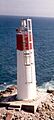
Lighthouses on the Island
To help ships avoid the island, a lighthouse was first built in 1839. This first lighthouse burned down in 1916. A new one, made of cast iron, was built in 1917. Then, in 1962, an automatic system took over.

Today, the lighthouse runs on solar power and works by itself. This means fewer people visit the island. Only Canadian Coast Guard helicopters come for maintenance. In the past, the island had a Marconi wireless station. Sometimes, amateur radio operators still visit and use the special callsign CY9. Other visitors include birdwatchers and SCUBA divers.
The island is also recognized as an Important Bird Area because of all the birds that live there.
Island Weather
St. Paul Island has a cool, wet climate, much like places near the Arctic, but it's also affected by the ocean. Sometimes, when warm winds blow from Cape Breton Island, the temperature can rise quickly for a short time.
The warmest temperature ever recorded on St. Paul Island was 30.0°C (86.0°F) on August 14, 1944. The coldest temperature ever recorded was -23.3°C (-9.9°F) on December 29, 1933, February 10, 1934, and February 6, 1950.
| Climate data for St Paul Island, Nova Scotia (extremes 1928–present) | |||||||||||||
|---|---|---|---|---|---|---|---|---|---|---|---|---|---|
| Month | Jan | Feb | Mar | Apr | May | Jun | Jul | Aug | Sep | Oct | Nov | Dec | Year |
| Record high °C (°F) | 16.5 (61.7) |
12.8 (55.0) |
13.9 (57.0) |
17.3 (63.1) |
22.2 (72.0) |
26.7 (80.1) |
28.3 (82.9) |
30.0 (86.0) |
26.7 (80.1) |
23.3 (73.9) |
19.9 (67.8) |
14.9 (58.8) |
30.0 (86.0) |
| Mean daily maximum °C (°F) | −2 (28) |
−3 (27) |
−1 (30) |
2 (36) |
7 (45) |
12 (54) |
18 (64) |
20 (68) |
16 (61) |
11 (52) |
5 (41) |
1 (34) |
7 (45) |
| Daily mean °C (°F) | −5 (23) |
−6 (21) |
−4 (25) |
0 (32) |
4 (39) |
9 (48) |
15 (59) |
16 (61) |
13 (55) |
8 (46) |
2 (36) |
−2 (28) |
4 (39) |
| Mean daily minimum °C (°F) | −8 (18) |
−10 (14) |
−7 (19) |
−2 (28) |
1 (34) |
6 (43) |
12 (54) |
13 (55) |
10 (50) |
5 (41) |
0 (32) |
−4 (25) |
1 (34) |
| Record low °C (°F) | −22.8 (−9.0) |
−23.3 (−9.9) |
−21.7 (−7.1) |
−14.4 (6.1) |
−3.9 (25.0) |
−0.6 (30.9) |
4.4 (39.9) |
5.6 (42.1) |
2.8 (37.0) |
−4.4 (24.1) |
−11.1 (12.0) |
−23.3 (−9.9) |
−23.3 (−9.9) |
| Average precipitation mm (inches) | 80 (3.1) |
80 (3.1) |
70 (2.8) |
60 (2.4) |
70 (2.8) |
70 (2.8) |
50 (2.0) |
60 (2.4) |
100 (3.9) |
100 (3.9) |
90 (3.5) |
100 (3.9) |
930 (36.6) |
| Source: Weatherbase | |||||||||||||
Images for kids
-
Saint Paul Island
-
Spraycan Lighthouse
