Browning, Wisconsin facts for kids
Quick facts for kids
Browning, Wisconsin
|
|
|---|---|

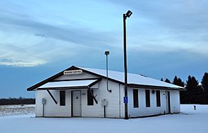
Browning Town Hall in November 2013.
|
|

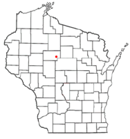
Location of Browning, Wisconsin
|
|
| Country | |
| State | |
| County | Taylor |
| Area | |
| • Total | 36.5 sq mi (94.6 km2) |
| • Land | 36.5 sq mi (94.5 km2) |
| • Water | 0.0 sq mi (0.0 km2) |
| Elevation | 1,499 ft (457 m) |
| Population
(2000)
|
|
| • Total | 850 |
| • Density | 23.3/sq mi (9.0/km2) |
| Time zone | UTC-6 (Central (CST)) |
| • Summer (DST) | UTC-5 (CDT) |
| Area code(s) | 715 & 534 |
| FIPS code | 55-10400 |
| GNIS feature ID | 1582875 |
| PLSS township | T31N R2E |
Browning is a small town located in Taylor County, Wisconsin, in the United States. In the year 2000, about 850 people lived there. A small community called Gad is also part of the town of Browning.
Contents
Geography of Browning
Browning covers an area of about 36.5 square miles (which is about 94.6 square kilometers). Almost all of this area is land, with very little water. The Little Black River has two branches, the east and west, that flow through the town.
The land in Browning is mostly flat or gently rolling. This is because of ancient glaciers that shaped the area a very long time ago. The soil in most of Browning is a type called Merrill till, which was left behind by these glaciers.
History of Browning
Early Land Surveys
The area that is now Browning was first mapped by government surveyors in 1851. They marked the southern and eastern edges. Later, in 1861, another group of surveyors marked all the corners of the land sections. They walked through forests and swamps, using tools like chains and compasses to measure the land.
After their work, the head surveyor wrote a description of the area. He said the land was "generally level or gently rolling." He also noted that the soil was good and the area had many trees like hemlock, birch, maple, pine, and spruce. He also mentioned that there were many small streams with clean water.
Railroad and Early Settlers
Around 1873, the Wisconsin Central Railroad built its tracks through the nearby forests. This railroad helped connect the area to places like Ashland. To help pay for building the railroad, the company was given half of the land for eighteen miles on both sides of the tracks. This usually meant they owned the odd-numbered sections of land.
An old map from 1880 shows some of the first roads in the area that would become Browning. One road followed the path of what is now Highway 64, going from west to east.
Forming the Town
When Taylor County was created in 1875, the area of Browning was part of a much larger town called Medford. But in 1895, Browning became its own separate town.
Life in the Early 1900s
Around 1900, maps showed that settlers had built homes along the roads, especially where Highway 64 is today. There was also a road along what is now County O, on the southern edge of the town.
In the northern part of the town, there were only a few roads. At one corner, there was a sawmill, a small school, and a post office called "Lynch P.O." Along the road that became Highway 64, there was a church, another school, and a sawmill. Another school was on what is now Hall Drive. Many parts of the town were still unsettled, and the railroad still owned large sections of land. Other big landowners included companies like Davis & Starr and individuals like P.A. Merino and E.F. Browning. There were also logging dams on both branches of the Little Black River.
By 1911, more roads had been built, and more settlers had moved in. A road now followed what is Grahl Road through the middle of Browning, with a sawmill and school at the center of the town. A town hall was built where Hall Drive crosses Highway 64. Some large areas in the north and east were still owned by big land companies.
Population Information
Based on the census from 2000, Browning had 850 people living in 298 households. Most people (98.47%) were White. About 2.59% of the population was of Hispanic or Latino background.
Many households (40.9%) had children under 18 living with them. Most families (71.8%) were married couples. The average household had about 2.85 people.
The population was spread out by age:
- About 28.9% were under 18 years old.
- About 32.8% were between 25 and 44 years old.
- About 8.6% were 65 years or older.
The average age in Browning was 35 years.
The average income for a household in Browning was about $45,917 per year. About 5.9% of the total population lived below the poverty line.
See also
 In Spanish: Browning (Wisconsin) para niños
 | Claudette Colvin |
 | Myrlie Evers-Williams |
 | Alberta Odell Jones |

