Buffalo, Kentucky facts for kids
Quick facts for kids
Buffalo
|
|
|---|---|
|
Census-designated place (CDP)
|
|

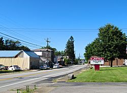
Kentucky Route 61 in Buffalo
|
|
| Country | United States |
| State | Kentucky |
| County | LaRue |
| Area | |
| • Total | 1.18 sq mi (3.06 km2) |
| • Land | 1.18 sq mi (3.06 km2) |
| • Water | 0.00 sq mi (0.00 km2) |
| Elevation | 748 ft (228 m) |
| Population
(2020)
|
|
| • Total | 571 |
| • Density | 483.49/sq mi (186.62/km2) |
| Time zone | UTC-5 (Eastern (EST)) |
| • Summer (DST) | UTC-4 (EDT) |
| Area code(s) | 270 |
| GNIS feature ID | 488299 |
Buffalo is a small community in LaRue County, Kentucky, in the United States. It's known as an unincorporated community. This means it doesn't have its own local government like a city or town. Instead, it's governed by the county.
Buffalo is also a census-designated place (CDP). This is a special area created by the United States Census Bureau just for counting people. It helps them gather information about populations in places that aren't official cities.
Where is Buffalo?
Buffalo is located in the southern part of LaRue County. You can find it along Kentucky Route 61. This road runs south of Hodgenville. Hodgenville is the main town, or county seat, of LaRue County.
The community sits at an elevation of 748 feet (228 meters) above sea level. Even though it's not an official city, Buffalo has its own post office. The ZIP code for Buffalo is 42716.
How Many People Live Here?
The number of people living in Buffalo changes over time. The United States Census Bureau counts the population every ten years.
Population Count
This shows that Buffalo is a small but growing community.
See also

- In Spanish: Buffalo (Kentucky) para niños


